Giant's Ring

Last updated

The Megalithic tomb at the centre of the Giant's Ring. Northern Ireland Belfast Giants Ring 001.jpg
The Megalithic tomb at the centre of the Giant's Ring.

The Giant's Ring is a henge monument at Ballynahatty, near Shaw's Bridge, Belfast, Northern Ireland. It was originally preserved by Viscount Dungannon. The inscribed stone tablet on the wall surrounding the site which details Viscount Dungannon's interest was carved by Belfast stonecarver Charles A Thompson about c.1919.[ citation needed ]

Contents

The site is a State Care Historic Monument [1] and has ASAI (Area of Significant Archaeological Interest) status. [2]

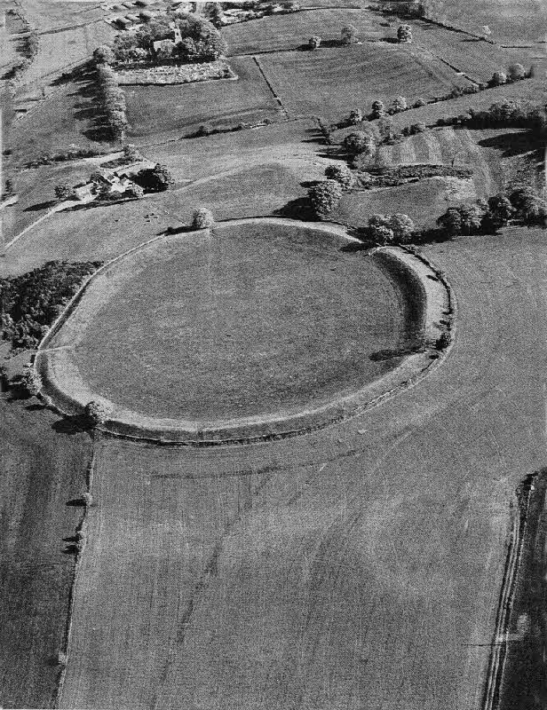
The site consists of a circular enclosure, 180 m (590 ft) in diameter and 2.8 hectares (6.9 acres) in area, surrounded by a circular earthwork bank 3.5 m (11 ft) high. At least three of the five irregularly spaced gaps in the bank are intentional and possibly original. East of the centre of the enclosure is a small passage tomb with a vestigial passage facing west. There were reports of other tombs outside the enclosure, but there is no trace of these. [3]

History

The Giant's Ring dates from the Neolithic period and was built around 2700BC, [4] meaning that it predates the Egyptian pyramids. The site has had some sort of public use throughout its history. It is near the Shaw's Bridge crossing of the River Lagan, a point which has been used as a crossing of the river since at least the Stone Age. [5] The original purpose of the monument was most likely as a meeting place or as a memorial to the dead.

Archaeologist Michael J. O'Kelly believed that the Giant's Ring, like hundreds of other passage tombs built in Ireland during the Neolithic period, such as Newgrange, showed evidence for a religion which venerated the dead as one of its core principles. He believed that this "cult of the dead" was just one particular form of European Neolithic religion, and that other megalithic monuments displayed evidence for different religious beliefs which were solar, rather than death-orientated. [6]

In the 18th century the site was used for horse racing. [7] A ritual site adjacent to the henge was excavated in the early 1990s by Barrie Hartwell of the Queen's University of Belfast. [8]

Giants Ring.jpg
A panorama of The Giant's Ring.

See also

Related Research Articles

<span class="mw-page-title-main">Ring of Brodgar</span> A neolithic stone circle in Orkney, Scotland

The Ring of Brodgar is a Neolithic henge and stone circle about 6 miles north-east of Stromness on Mainland, the largest island in Orkney, Scotland. It is part of the UNESCO World Heritage Site known as the Heart of Neolithic Orkney.

<span class="mw-page-title-main">Newgrange</span> Neolithic monument in County Meath, Ireland

Newgrange is a prehistoric monument in County Meath in Ireland, located on a rise overlooking the River Boyne, 8 kilometres (5.0 mi) west of Drogheda. It is an exceptionally grand passage tomb built during the Neolithic Period, around 3200 BC, making it older than Stonehenge and the Egyptian pyramids. It is aligned on the winter solstice sunrise. Newgrange is the main monument in the Brú na Bóinne complex, a World Heritage Site that also includes the passage tombs of Knowth and Dowth, as well as other henges, burial mounds and standing stones.

<span class="mw-page-title-main">Megalith</span> Large stone used to build a structure or monument

A megalith is a large stone that has been used to construct a prehistoric structure or monument, either alone or together with other stones. There are over 35,000 in Europe alone, located widely from Sweden to the Mediterranean sea.

<span class="mw-page-title-main">Henge</span> Type of Neolithic earthwork

There are three related types of Neolithic earthwork that are all sometimes loosely called henges. The essential characteristic of all three is that they feature a ring-shaped bank and ditch, with the ditch inside the bank. Because the internal ditches would have served defensive purposes poorly, henges are not considered to have been defensive constructions. The three henge types are as follows, with the figure in brackets being the approximate diameter of the central flat area:

  1. Henge. The word henge refers to a particular type of earthwork of the Neolithic period, typically consisting of a roughly circular or oval-shaped bank with an internal ditch surrounding a central flat area of more than 20 m (66 ft) in diameter. There is typically little if any evidence of occupation in a henge, although they may contain ritual structures such as stone circles, timber circles and coves. Henge monument is sometimes used as a synonym for henge. Henges sometimes, but by no means always, featured stone or timber circles, and circle henge is sometimes used to describe these structures. The three largest stone circles in Britain are each within a henge. Examples of henges without significant internal monuments are the three henges of Thornborough Henges. Although having given its name to the word henge, Stonehenge is atypical in that the ditch is outside the main earthwork bank.
  2. Hengiform monument. Like an ordinary henge, except the central flat area is between 5 and 20 m (16–66 ft) in diameter, they comprise a modest earthwork with a fairly wide outer bank. The terms Mini henge or Dorchester henge are sometimes used as synonyms for hengiform monument. An example is the Neolithic site at Wormy Hillock Henge.
  3. Henge enclosure. A Neolithic ring earthwork with the ditch inside the bank, with the central flat area having abundant evidence of occupation and usually being more than 300 m (980 ft) in diameter. Some true henges are as large as this, but lack evidence of domestic occupation. Super henge is sometimes used as a synonym for a henge enclosure. However, sometimes Super henge is used to indicate size alone rather than use, e.g. "Marden henge ... is the least understood of the four British 'superhenges' ".
<span class="mw-page-title-main">Bryn Celli Ddu</span> Neolithic burial chamber on Anglesey

Bryn Celli DduWelsh pronunciation: [brʌn keːɬi ðɨː] is a prehistoric site on the Welsh island of Anglesey located near Llanddaniel Fab. Its name means 'the mound in the dark grove'. It was archaeologically excavated between 1928 and 1929. Visitors can get inside the mound through a stone passage to the burial chamber, and it is the centrepiece of a major Neolithic Scheduled Monument in the care of Cadw. The presence of a mysterious pillar within the burial chamber, the reproduction of the 'Pattern Stone', carved with sinuous serpentine designs, and the fact that the site was once a henge with a stone circle, and may have been used to plot the date of the summer solstice have all attracted much interest.

<span class="mw-page-title-main">Dowth</span> Neolithic passage tomb located in the Boyne Valley, County Meath, Ireland

Dowth is a Neolithic passage tomb located in the Boyne Valley, County Meath, Ireland. It is one of the three principal tombs of the Brú na Bóinne World Heritage Site – a landscape of prehistoric monuments including the large passage-tombs of Dowth, Dowth Hall, Newgrange and Knowth. Unlike Newgrange and Knowth, Dowth has not been independently dated, but its features align it with the other passage tombs which date from between approximately 3200 and 2900 BC. However, Harbison (1970) dates the tomb at 2500 – 2000 BC. It is less developed as a tourist attraction than its neighbours, partly because the chamber is much lower, and partly because the decoration is less visible. It was partly excavated, in 1847 by the Royal Irish Academy who dynamited the roof causing the still visible crater, though it was pillaged by Vikings and earlier looters long before that.

<span class="mw-page-title-main">Carrowmore</span> Megalithic cemetery in County Sligo, Ireland

<span class="mw-page-title-main">Brú na Bóinne</span> Archaeological site in County Meath, Ireland

Brú na Bóinne or Boyne valley tombs, is an area in County Meath, Ireland, located in a bend of the River Boyne. It contains one of the world's most important prehistoric landscapes dating from the Neolithic period, including the large Megalithic passage graves of Knowth, Newgrange and Dowth as well as some 90 additional monuments. The archaeological culture associated with these sites is called the "Boyne culture".

<span class="mw-page-title-main">Monknewtown</span>

Monknewtown, historically called Rathenskin, is a townland 3 km east of Slane in County Meath, Ireland. It stands on the right bank of the Mattock River, which feeds several historic watermills nearby and which forms approximately the townland's eastern boundary with Keerhan and Sheepgrange townlands in County Louth. Neighbouring townlands to the south are Balfeddock, Knowth, and Crewbane, to the west Cashel, Mooretown, and Knockmooney. The northern boundary of Monknewtown with Kellystown is formed by a tributary of the Mattock River, while the southern boundary is formed by the N51 road. Other than the latter, only minor roads traverse the townland, among them L5606 from west to east.

<span class="mw-page-title-main">Ballylesson</span>

Ballylesson is a small village and townland in County Down, Northern Ireland. In the 2001 Census it had a population of 108 people. The village lies within the Lagan Valley Regional Park and the Lisburn City Council area.

<span class="mw-page-title-main">Hill of Uisneach</span> Hill in County Westmeath, Ireland

The Hill of Uisneach or Ushnagh is a hill and ancient ceremonial site in the barony of Rathconrath in County Westmeath, Ireland. It is a protected national monument. It consists of numerous monuments and earthworks—prehistoric and medieval—including a probable megalithic tomb, burial mounds, enclosures, standing stones, holy wells and a medieval road. Uisneach is near the geographical centre of Ireland, and in Irish mythology it is deemed to be the symbolic and sacred centre of the island. It was said to be the burial place of the mythical Tuatha Dé Danann, and a place of assembly associated with the druids and the festival of Bealtaine.

This article describes several characteristic architectural elements typical of European megalithic structures.

<span class="mw-page-title-main">Ballynahatty, County Down</span>

Ballynahatty is a townland in County Down, Northern Ireland. It lies on the southern edge of Belfast. It contains the Giants Ring, a henge monument.

<span class="mw-page-title-main">Stone circles in the British Isles and Brittany</span> Megalithic tradition of monuments

The stone circles in the British Isles and Brittany are a megalithic tradition of monuments consisting of standing stones arranged in rings. These were constructed from 3300 to 900 BCE in Britain, Ireland and Brittany. It has been estimated that around 4,000 of these monuments were originally constructed in this part of north-western Europe during this period. Around 1,300 of them are recorded, the others having been destroyed.

<i>Rites of the Gods</i> Book by Aubrey Burl

Rites of the Gods is an archaeological study of religious belief and ritual practices across prehistoric Britain from the Old Stone Age through to the Iron Age. Written by the prominent English archaeologist and megalithic specialist Aubrey Burl, it was first published in 1981 by J.M. Dent & Sons Ltd.

<i>The Significance of Monuments</i> Book by Richard Bradley

The Significance of Monuments: On the Shaping of Human Experience in Neolithic and Bronze Age Europe is an archaeological book authored by the English academic Richard Bradley of the University of Reading. It was first published by Routledge in 1998.

<span class="mw-page-title-main">British megalith architecture</span>

British megalith architecture is the study of those ancient cultures that built megalithic sites on the British Isles, including the research and documentation of these sites. The classification sometimes used of these cultures based on geological criteria is problematic.

<span class="mw-page-title-main">Knockroe Passage Tomb</span> Neolithic passage tomb

Knockroe Passage Tomb is a prehistoric site, of the Neolithic period, in the townland of Knockroe in County Kilkenny, Ireland, about 10 km north of Carrick-on-Suir. It is known locally as "The Caiseal".

References

  1. "State Care Historic Monuments" (PDF). ehsni.gov.uk. Environment and Heritage Service. 31 March 2007. Archived from the original (PDF) on 22 July 2012. Retrieved 17 August 2012.
  2. "Part 4, District Proposals: Lisburn Countryside Urban Environment". Belfast Metropolitan Area Plan 2015 (draft). Department of the Environment (Northern Ireland). November 2004. Retrieved 17 August 2012.
  3. Weir, A (1980). Early Ireland. A Field Guide. Belfast: Blackstaff Press. p. 133.
  4. Giants Ring
  5. "Giant's Ring Trail, Belfast | Great British walks". 11 May 2012.
  6. O'Kelly, Michael J. 1982. Newgrange: Archaeology, Art and Legend. London: Thames and Hudson. Page 122.
  7. Giants Ring : Visit Lisburn : Lisburn Tourism Guide Lisburn City Guide Lisburn City Council Information Centre Northern Ireland Archived 2007-02-18 at the Wayback Machine
  8. Hartwell, Barrie (1995). "The Prehistory of the Giant's Ring and Ballynahatty Townland". Lisburn Historical Society Journal. 9. Retrieved 17 August 2012.

Further reading

54°32′25″N5°57′0″W / 54.54028°N 5.95000°W / 54.54028; -5.95000