Ruddington is a large village in the Borough of Rushcliffe in Nottinghamshire, England. The village is 5 miles (8 km) south of Nottingham and 11 miles (18 km) northwest of Loughborough. It had a population of 6,441 at the 2001 Census, increasing to 7,216 at the 2011 Census and 7,674 in 2021. Ruddington is twinned with Grenay, France.

Kingston on Soar is a village and civil parish in the Rushcliffe borough of Nottinghamshire, England.

Meering is a geographically small civil parish in the Newark and Sherwood district of Nottinghamshire, England. With a population of zero, it is grouped with Girton to form a parish meeting. The parish was originally an extra-parochial area, and was once populated, although not in more than single figures since census records began.
Annesley is a village and civil parish in the Ashfield district of Nottinghamshire, England, between Hucknall and Kirkby-in-Ashfield. At the 2011 census, it had a population of 1,162, and this increased to 1,814 at the 2021 census.

Averham is a village and civil parish in the Newark and Sherwood district of Nottinghamshire, England. According to the 2001 census it had a population of 187, increasing to 294 at the 2011 census, however Averham alone reported 215 residents at the 2021 census. The village is just west of Newark-on-Trent. Staythorpe Power Station is south-west of the village.

Besthorpe is a small village in north-east Nottinghamshire close to the border with Lincolnshire. It is a civil parish in the Newark & Sherwood district of Nottinghamshire. The population of the civil parish as of the 2011 census was 195, increasing to 212 at the 2021 census. The village is on the A1133 between Newark and Gainsborough, and is 1.5 miles north of the larger village of Collingham, north east of Newark on Trent. The village lies 1 mile east of the River Trent and the River Fleet flows south to east parallel with the village & A1133. Besthorpe acquired Conservation Village status in 2006 because it has maintained much of its original layout focused on Low Road and the Green.

Linby is a small village and civil parish in Nottinghamshire, England. The nearest town is Hucknall which is immediately to the south-west. The village grew up around the mills on the River Leen, from which Linby's name is derived. Small streams known as Linby Docks run on both sides of the main street. The population of the civil parish at the 2011 census was 232, increasing to 676 at the 2021 census.

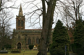
Papplewick is a village and civil parish in Nottinghamshire, England, 7.5 miles (12.1 km) north of Nottingham and 6 miles (9.7 km) south of Mansfield. It had a population of 756 at the 2011 census, and 651 at the 2021 census. In the Middle Ages, the village marked the southern gateway to Sherwood Forest.

Gringley on the Hill, Nottinghamshire, is an English village and parish. The population of the civil parish at the 2011 census was 699, increasing to 854 in 2021. It is on the highest part of the road from Bawtry to Gainsborough, six miles east-southeast of the former, and the same distance west by north of the latter town.

Hawton is a hamlet and civil parish in the Newark and Sherwood district of Nottinghamshire, England. It lies two miles (3.2 km) south of the town of Newark-on-Trent, near the River Devon, a tributary of the River Trent. Its population was recorded as 147 in the 2011 census. Hawton alone reported 80 residents at the 2021 census.

Winthorpe is a village and civil parish located 2 miles (3 km) northeast of Newark-on-Trent in Nottinghamshire, England. The population at the 2011 census was 650, falling to 595 at the 2021 census. The name is probably from old English wynne þrop (thorp), which translates as 'hamlet of joy'. An alternative etymology is Wigmund 's or Vigmund 's village.

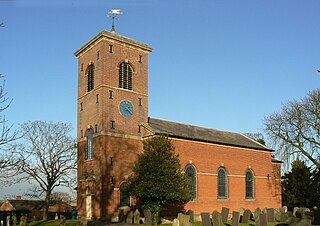
Sutton Cum Lound is a village located in Bassetlaw, north Nottinghamshire. It is located 3 miles from Retford. The civil parish is called Sutton. According to the 2001 census it had a population of 687, falling slightly to 673 at the 2011 census, and recovering to 683 at the 2021 census. The parish church of St Bartholomew is Norman, rebuilt in the Perpendicular style, with "unbridled curvilinear tracery" in the chancel windows. The village has a primary school. It borders the village of Barnby Moor which is about 1 mile away and is also very close to the village of Lound. The village has a number of public footpaths and walks such as those on Mire Hill.
Kinoulton is a village, civil parish and ecclesiastical parish in Nottinghamshire, England, 11 miles (18 km) south east of the city of Nottingham. It is probably Saxon in origin, and once had a brick-making industry. It is close to the A46 road, and has a population of about 1,000.

Halam is a village and civil parish in the Newark and Sherwood district of Nottinghamshire, England, with a population of 372 in 2001, increasing to 426 at the 2011 census, and 387 at the 2021 census. It is located to the west of Southwell.

Thrumpton is a village and civil parish in Nottinghamshire, England. At the time of the 2001 census it had a population of 152, increasing to 165 at the 2011 census, and 178 at the 2021 census. It is located on the A453 road 6 miles (9.7 km) south-west of West Bridgford. The 13th century Church of All Saints is Grade II* listed and was restored in 1871. Many of the gabled brick houses in the village were built between 1700 and 1745 by John Emerton of Thrumpton Hall.

Kirton is a village and civil parish in Nottinghamshire, England. It is located 3 miles (4.8 km) east of Ollerton. According to the United Kingdom Census 2001 it had a population of 273, reducing to 261 at the 2011 census, and rising to 267 at the 2021 census.
Caythorpe is a village and civil parish in Nottinghamshire, England. It is situated 10 miles (16 km) north-east from Nottingham, close to the River Trent. According to the 2001 census, it had a population of 259, increasing to 271 at the time of the 2011 census,. and dropping to 257 at the 2021 census.

South Clifton is a village and civil parish in the Newark and Sherwood district of Nottinghamshire, England. It is 11 miles north of Newark-on-Trent. With the 2011 census, the parish had a population of 326, this fell to 308 at the 2021 census. The parish touches Thorney, Girton, Fledborough, Wigsley, Marnham, Normanton on Trent, Spalford and North Clifton.
Styrrup with Oldcotes is a civil parish in the Bassetlaw district, within the county of Nottinghamshire, England. The overall area had a population of 731 at the 2021 census, an increase from 684 at the 2011 census. The parish lies in the north of the county. It is 31 miles north of Nottingham, and 15 miles east of Sheffield. The parish rests alongside the county border with South Yorkshire.

Rampton and Woodbeck is a civil parish in the Bassetlaw district, within the county of Nottinghamshire, England. The overall area had a population of 1,077 at the 2021 census. The parish lies in the north east of the county. It is 125 miles north west of London, 27 miles north east of the city of Nottingham, and 5 miles south east of the town of Retford. The parish rests alongside the county border with Lincolnshire. It is the site of Rampton Secure Hospital, which is one of only three high security psychiatric hospitals in England.


