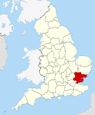
East Northamptonshire
| Name | Location | Type | Completed [note 1] | Date designated | Grid ref. [note 2] Geo-coordinates | Entry number [note 3] | Image |
|---|---|---|---|---|---|---|---|
| Ashton Mill | Ashton, East Northamptonshire | Corn Mill | C17-19 | 12 May 1969 | TL0516688217 52°28′54″N0°27′10″W / 52.481752°N 0.452844°W | 1040278 |  |
| Home Farm Cottage | Ashton Wold, Ashton | House | 1900–1901 | 13 November 1998 | TL0892987904 52°28′42″N0°23′51″W / 52.478202°N 0.397559°W | 1245640 |  Upload Photo |
| Home Farm, Farmbuildings | Ashton Wold, Ashton | Dovecote | 1900–1901 | 13 November 1998 | TL0895787934 52°28′42″N0°23′50″W / 52.478466°N 0.397137°W | 1271732 | Upload Photo |
| Home Farm, the Old Dairy | Ashton Wold, Ashton | Dairy | 1900–1901 | 13 November 1998 | TL0895287896 52°28′41″N0°23′50″W / 52.478126°N 0.397223°W | 1271734 | Upload Photo |
| All Saints Chancel | Barnwell All Saints, Barnwell | Church | 13th century | 23 May 1967 | TL0486984417 52°26′52″N0°27′30″W / 52.44766°N 0.458409°W | 1294446 |  |
| Biggin Hall | Benefield | Country House | Medieval origins | 23 May 1967 | TL0108889137 52°29′27″N0°30′45″W / 52.49079°N 0.512592°W | 1040213 |  |
| Church of St Mary | Lower Benefield, Benefield | Church | Medieval | 23 May 1967 | SP9881288470 52°29′07″N0°32′47″W / 52.485212°N 0.546299°W | 1189042 | 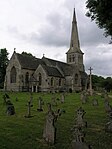 |
| Church of the Holy Trinity | Blatherwycke | Church | 11th century to 14th century | 23 May 1967 | SP9743595762 52°33′04″N0°33′52″W / 52.550993°N 0.564436°W | 1040093 |  |
| Fermyn Woods Hall, and attached Stables and ancillary Buildings | Brigstock | Country House | Early/mid 17th century | 23 May 1967 | SP9581687120 52°28′25″N0°35′27″W / 52.473613°N 0.590792°W | 1189160 |  |
| Manor House | Brigstock | Hall House | 12th-century origins | 26 May 1967 | SP9452785228 52°27′25″N0°36′37″W / 52.456833°N 0.610298°W | 1040166 | Upload Photo |
| Bulwick Hall and attached Entrance Loggia and Garden Room | Bulwick Park, Bulwick | Country House | c. 1676 | 23 May 1967 | SP9588794050 52°32′09″N0°35′16″W / 52.535882°N 0.587752°W | 1293383 | 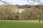 |
| Gates and Gatepiers about 150m south-west of Bulwick Hall | Bulwick Park, Bulwick | Gate | Early 18th century | 23 May 1967 | SP9580293904 52°32′05″N0°35′21″W / 52.534584°N 0.589047°W | 1374888 | Upload Photo |
| Church of St John the Baptist | Caldecott, Chelveston cum Caldecott | Church | Mid 13th century | 23 May 1967 | SP9884569126 52°18′41″N0°33′05″W / 52.311358°N 0.551517°W | 1040380 |  |
| Church of St Andrew | Collyweston | Church | 11th century | 23 May 1967 | SK9960702885 52°36′53″N0°31′49″W / 52.614614°N 0.530274°W | 1374873 |  |
| Church of St Peter | Deene Park, Deene | Bust | 1722 | 23 May 1967 | SP9519092748 52°31′27″N0°35′54″W / 52.524302°N 0.598398°W | 1040134 |  |
| Church of St Mary | Duddington, Duddington-with-Fineshade | Church | mid and late 12th century | 23 May 1967 | SK9877400884 52°35′48″N0°32′35″W / 52.596783°N 0.54317°W | 1040104 |  |
| Glebe House and attached Steps and Railings | Easton on the Hill | House | 1988 | 23 May 1967 | TF0093704591 52°37′47″N0°30′36″W / 52.6297°N 0.510117°W | 1225510 | Upload Photo |
| Priest's House | Easton on the Hill | Priests House | Early 16th century | 23 May 1967 | TF0097204548 52°37′46″N0°30′35″W / 52.629307°N 0.509614°W | 1225369 | 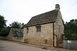 |
| RAF Wittering: Nuclear Fissile Core Stores, Buildings A09, A10, A11, A14, A15, A27, VW28, A29 and A33 | Easton on the Hill, East Northamptonshire | Nuclear Fissile Core Store | Built 1952 | 11 July 2011 | TF0148201667 52°36′12″N0°30′11″W / 52.603321°N 0.502965°W | 1402763 | Upload Photo |
| Church of St Leonard | Glapthorn | Church | 12th century | 23 May 1967 | TL0242290202 52°30′00″N0°29′33″W / 52.500112°N 0.492625°W | 1371965 | 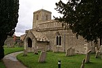 |
| Church of All Saints | Great Addington | Church | 12th century | 23 May 1967 | SP9586275114 52°21′57″N0°35′37″W / 52.365703°N 0.593552°W | 1040381 | 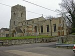 |
| Church of All Saints and Chest Tomb attached to North Aisle | Hargrave | Church | Late 12th century | 23 May 1967 | TL0365970638 52°19′27″N0°28′50″W / 52.324059°N 0.480464°W | 1191820 |  |
| Harringworth Lodge | Harringworth | Hunting Lodge | 13th century origins | 23 May 1967 | SP9320895269 52°32′50″N0°37′37″W / 52.547302°N 0.626895°W | 1040116 |  |
| Church of St Peter and St Paul | Hemington | Church | 13th-century origins | 23 May 1967 | TL0918884996 52°27′07″N0°23′41″W / 52.452018°N 0.394698°W | 1040226 |  |
| College House | Higham Ferrers | House | 1633 | 23 September 1950 | SP9604668651 52°18′27″N0°35′34″W / 52.307585°N 0.592696°W | 1040389 | Upload Photo |
| 5 Market Square | Higham Ferrers | House | Mid 17th century | 23 September 1950 | SP9601968497 52°18′22″N0°35′35″W / 52.306205°N 0.593136°W | 1371874 | Upload Photo |
| Hall Farmhouse | King's Cliffe | Farmhouse | Late Medieval | 23 May 1967 | TL0075997066 52°33′44″N0°30′54″W / 52.562107°N 0.515035°W | 1225654 | Upload Photo |
| Church of All Saints | Laxton | Church | 12th century | 23 May 1967 | SP9505596011 52°33′13″N0°35′58″W / 52.553651°N 0.599454°W | 1233912 |  |
| Laxton Hall and attached Steps and Balustrade | Laxton Park, Laxton | Country House | Late 18th century | 23 May 1967 | SP9597997065 52°33′47″N0°35′08″W / 52.562962°N 0.585526°W | 1276360 | 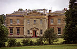 |
| Church of St John the Baptist | Slipton, Lowick | Church | 13th century | 23 May 1967 | SP9525779341 52°24′14″N0°36′04″W / 52.403798°N 0.601235°W | 1040269 | 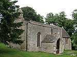 |
| Flight of Steps with Urns adjacent to north Front of Drayton House | Drayton Park, Lowick | Steps | Early 18th century | 31 July 1987 | SP9630680064 52°24′36″N0°35′08″W / 52.410113°N 0.585613°W | 1040297 | Upload Photo |
| Flight of Steps with Urns about 90m east of east Front of Drayton House | Drayton Park, Lowick, East Northamptonshire | Steps | Early 18th century | 31 July 1987 | SP9637680132 52°24′39″N0°35′04″W / 52.410711°N 0.584564°W | 1040301 | Upload Photo |
| Retaining Wall, Steps and Urns extending about 80m from south to east Front of Drayton House | Drayton Park, Lowick | Garden Wall | Late 16th century | 31 July 1987 | SP9637580078 52°24′37″N0°35′05″W / 52.410226°N 0.584594°W | 1040299 | Upload Photo |
| Stables attached to south-west of Drayton House | Drayton Park, Lowick | Wall | mid/late 17th century | 23 May 1967 | SP9636079957 52°24′33″N0°35′05″W / 52.409141°N 0.58485°W | 1192040 | Upload Photo |
| Statue of Bacchus about 25m east of east Front of Drayton House | Drayton Park, Lowick | Statue | c. 1718 | 31 July 1987 | SP9633280100 52°24′38″N0°35′07″W / 52.410432°N 0.58522°W | 1371924 | Upload Photo |
| Statue of Flora around 25m east of east Front of Drayton House | Drayton Park, Lowick | Statue | c. 1718 | 31 July 1987 | SP9635780087 52°24′37″N0°35′05″W / 52.41031°N 0.584856°W | 1192227 | Upload Photo |
| Statue of Samson and the Philistine about 110m east of east Front of Drayton House | Drayton Park, Lowick, East Northamptonshire | Statue | Early 18th century | 31 July 1987 | SP9639480155 52°24′39″N0°35′03″W / 52.410915°N 0.584293°W | 1371923 | Upload Photo |
| Walls, Gatepier and attached Banqueting House and Balustrade about 80m east of Drayton House | Drayton Park, Lowick, East Northamptonshire | Balustrade | Late 17th century | 23 May 1967 | SP9634780146 52°24′39″N0°35′06″W / 52.410842°N 0.584986°W | 1040298 | Upload Photo |
| Walls, Gatepiers, Gates and Screens south and east of Drayton House; and Banqueting House, Balustrade, Statue and Cistern | Drayton Park, Lowick | Balustrade | late C17/early 18th century | 23 May 1967 | SP9646079966 52°24′33″N0°35′00″W / 52.409205°N 0.583378°W | 1371922 | Upload Photo |
| Church of St Margaret | Luddington-in-the-Brook, Luddington | Church | 13th century to 15th century | 23 May 1967 | TL1031383665 52°26′23″N0°22′43″W / 52.439831°N 0.37859°W | 1040228 | 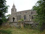 |
| Manor House | Nassington | Manor House | Early 16th century | 23 May 1967 | TL0628896176 52°33′11″N0°26′02″W / 52.553059°N 0.433788°W | 1065895 | Upload Photo |
| Bramston House Central Building | Oundle | House | Late 17th century | 18 June 1955 | TL0420088072 52°28′50″N0°28′02″W / 52.480634°N 0.467108°W | 1039859 | Upload Photo |
| Bramston House East Wing | Oundle | House | 18th century | 18 June 1955 | TL0421588086 52°28′51″N0°28′01″W / 52.480757°N 0.466883°W | 1039860 | Upload Photo |
| Branston House West Wing | Oundle | House | Early 18th century | 18 June 1955 | TL0418788062 52°28′50″N0°28′02″W / 52.480547°N 0.467303°W | 1190599 | Upload Photo |
| Latham's Hospital | Oundle | Almshouses | 1830 | 18 June 1955 | TL0428588308 52°28′58″N0°27′57″W / 52.482739°N 0.465784°W | 1039800 | 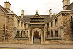 |
| Oundle School Memorial Chapel | Oundle | School | 1922-3 | 7 June 1974 | TL0383388338 52°28′59″N0°28′21″W / 52.483094°N 0.472428°W | 1039825 | Upload Photo |
| Paine's Almshouses | Oundle | Wall | Early 17th century | 18 June 1955 | TL0384788113 52°28′52″N0°28′20″W / 52.48107°N 0.472292°W | 1039816 | 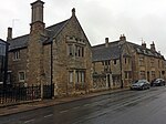 |
| Stable Block and Barn to West of No 16 including linking Wall and Gate Piers | Oundle | Gate | 18 June 1955 | TL0400588065 52°28′50″N0°28′12″W / 52.480608°N 0.469981°W | 1039780 | Upload Photo | |
| The White Lion Public House | Oundle | Public House | Early 17th century | 18 June 1955 | TL0425588164 52°28′53″N0°27′59″W / 52.48145°N 0.46627°W | 1039840 | Upload Photo |
| Upper House | Oundle | House | 18 June 1955 | TL0426488191 52°28′54″N0°27′58″W / 52.481691°N 0.466129°W | 1039841 | Upload Photo | |
| 12 North Street | Oundle | House | 1661 | 7 June 1974 | TL0425788183 52°28′54″N0°27′58″W / 52.481621°N 0.466235°W | 1293575 | Upload Photo |
| 4 and 6 Market Place | Oundle | House | Early 18th century | 18 June 1955 | TL0412588075 52°28′50″N0°28′06″W / 52.480675°N 0.468211°W | 1293722 | Upload Photo |
| 13 Market Place | Oundle | House | Late 17th century | 18 June 1955 | TL0416788112 52°28′52″N0°28′03″W / 52.481°N 0.467582°W | 1372120 | Upload Photo |
| Church of St Mary and All Saints | Pilton | Church | Late 12th century | 23 May 1967 | TL0247784546 52°26′57″N0°29′37″W / 52.449272°N 0.493552°W | 1294190 | 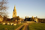 |
| Churchyard Cross about 8m south of South Aisle of Church of St Peter | Raunds | Cross | 14th century or 15th century | 26 April 1950 | TL0004073068 52°20′48″N0°31′58″W / 52.346569°N 0.532823°W | 1371901 | Upload Photo |
| No 59, Thorpe St (Thorpe House) and attached Wall to South | Raunds | Farmhouse | Mid 16th century | 26 April 1950 | SP9989472344 52°20′24″N0°32′07″W / 52.340089°N 0.53518°W | 1040345 | Upload Photo |
| Rushden Hall | Rushden | Country House/Offices | 14th century or 15th century | 9 December 1949 | SP9560566323 52°17′12″N0°35′59″W / 52.286739°N 0.599822°W | 1225991 | Upload Photo |
| Church of St Mary | Southwick | Church | 14th century | 23 May 1967 | TL0208592081 52°31′01″N0°29′49″W / 52.517062°N 0.497012°W | 1190967 |  |
| Stanwick Hall | Stanwick | Country House | 17th century | 26 April 1950 | SP9753171197 52°19′49″N0°34′13″W / 52.330205°N 0.570185°W | 1192263 | Upload Photo |
| The Old Rectory | Stanwick | House | 1717 | 26 April 1950 | SP9793571469 52°19′57″N0°33′51″W / 52.332578°N 0.564179°W | 1286673 | Upload Photo |
| Church of St Rumbald | Stoke Doyle | Church | c1722-25 | 23 May 1967 | TL0265486261 52°27′53″N0°29′26″W / 52.464652°N 0.490421°W | 1040178 | 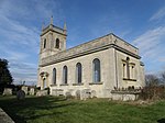 |
| Church of All Saints | Sudborough | Cross | Saxon | 23 May 1967 | SP9676882108 52°25′42″N0°34′42″W / 52.428401°N 0.578232°W | 1226485 |  |
| Church of St Mary the Virgin | Tansor | Church | Late 11th century | 23 May 1967 | TL0535390894 52°30′21″N0°26′57″W / 52.505773°N 0.449246°W | 1191175 |  |
| Church of St John the Baptist | Achurch, Thorpe Achurch | Church | Early 13th century | 23 May 1967 | TL0213883136 52°26′12″N0°29′56″W / 52.436664°N 0.498969°W | 1040142 | 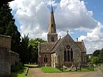 |
| Church of St James | Thrapston | Church | 13th century | 23 May 1967 | SP9970378698 52°23′50″N0°32′10″W / 52.397228°N 0.536096°W | 1265715 |  |
| Church of St Nicholas | Twywell | Church | 12th century | 23 May 1967 | SP9518078183 52°23′36″N0°36′10″W / 52.393404°N 0.602695°W | 1226021 |  |
| Church of St Michael and All Angels | Wadenhoe | Church | Late 12th century | 23 May 1967 | TL0086383284 52°26′18″N0°31′04″W / 52.438231°N 0.517673°W | 1227141 |  |
| Manor House | Warmington | Manor House | 1677 | 23 May 1967 | TL0770391284 52°30′32″N0°24′52″W / 52.508819°N 0.414511°W | 1191298 |  |
| Manor House Farmhouse | Woodford | Farmhouse | 1987 | 23 May 1967 | SP9666776838 52°22′52″N0°34′52″W / 52.381056°N 0.581237°W | 1225978 | Upload Photo |
| Church of St Mary | Woodnewton | Church | 11th century to 15th century | 23 May 1967 | TL0321094572 52°32′21″N0°28′47″W / 52.539236°N 0.479666°W | 1065862 | 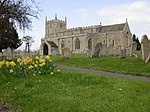 |
| Church of St Mary Magdalene | Yarwell | Church | 13th century | 23 May 1967 | TL0709497761 52°34′02″N0°25′17″W / 52.567145°N 0.421394°W | 1225878 | 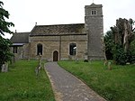 |