Grafton station (MBTA)

Last updated
Grafton
Grafton MBTA station, Outbound, North Grafton MA.jpg
Grafton station in May 2012
General information
Location1 Pine Street
North Grafton, Grafton, Massachusetts
Coordinates 42°14′47″N71°41′09″W / 42.2463°N 71.6859°W / 42.2463; -71.6859
Line(s) Worcester Line
Platforms2 side platforms
Tracks2
ConnectionsAiga bus trans.svg WRTA: B
Construction
Parking373 spaces ($4.00 fee)
Bicycle facilities8 spaces
AccessibleYes
Other information
Fare zone8
History
OpenedFebruary 23, 2000 [1]
Passengers
2018528 (weekday average boardings) [2]
Services
Preceding station MBTA.svg MBTA Following station
Worcester
Terminus
Framingham/​Worcester Line Westborough

Grafton station is an MBTA Commuter Rail station in the North Grafton village of Grafton, Massachusetts, served by the Framingham/Worcester Line. The station is fully accessible, with mini-high platforms serving both of the line's two tracks.

Contents

A former station at North Grafton was open from the 1800s until 1960. The modern station, located near Tufts University's Cummings School of Veterinary Medicine 1.3 miles (2.1 km) east of the former station, opened in 2000.

History

Former station

North Grafton station in the early 1900s North Grafton station postcard.jpg
North Grafton station in the early 1900s

The Boston and Worcester Railroad, which later became part of the Boston and Albany Railroad (B&A) opened to Worcester on July 4, 1835. [3] :342 Grafton station was established near New England Village (later called North Grafton) along the road to Shrewsbury by 1838. [4] [5] The Grafton Centre Railroad, a 3-mile (4.8 km) narrow-gauge feeder line, opened on August 20, 1874. Grafton station was renamed North Grafton to differentiate it from the Grafton Centre terminus. [6] The branch line was converted to standard gauge in 1887, renamed the Grafton and Upton Railroad (G&U) in 1888, and extended to Milford in 1890. [6]

The G&U was electrified in 1902; passenger service was provided by streetcars operated by the Milford and Uxbridge Street Railway. [6] North Grafton was a transfer point between B&A trains, G&U streetcars, and Worcester Consolidated Street Railway streetcars on the Worcester–Westborough line and Grafton Centre branch. Under great financial strain, the Worcester Consolidated cut its unprofitable suburban lines between 1925 and 1931. Westborough service ended in 1927; Grafton service lasted until 1931. [7] Streetcar service on the G&U ended on August 31, 1928, though freight service continued. [3] :369 The G&U has continued to use a yard at North Grafton, where the freight house (built between 1930 and 1957) remains in use by the railroad. [8]

Grafton station continued to be served by B&A commuter trains. [9] [10] The station was closed on April 24, 1960 when the B&A dropped almost all stops west of Framingham as part of service cuts. [11] In August 1973, the 1964-formed Massachusetts Bay Transportation Authority (MBTA) began subsidizing service (operated by Penn Central since 1968) between Boston and Framingham. On October 27, 1975, the one remaining Worcester round trip was cut back to Framingham. [11]

Modern station

The station viewed from the footbridge in 2012 Grafton station platforms from footbridge, June 2012.JPG
The station viewed from the footbridge in 2012

In 1994, service to Worcester was restored as mitigation for delays with reopening the Old Colony Lines. Service initially ran nonstop from Framingham to Worcester, but intermediate park and ride stops were added later as mitigation for delays in reopening the Greenbush Line. Grafton station opened on February 23, 2000 - the first of the four infill stations to open on the Framingham/Worcester Line. [1] The modern station is 1.3 miles (2.1 km) east of the former North Grafton station site; it is located off Massachusetts Route 30 adjacent to the Cummings School of Veterinary Medicine and other redevelopment of the former Grafton State Hospital. The station is intended to support transit-oriented development of additional sections of the former hospital site. [12]

The station has two low-level side platforms serving the two tracks of the Worcester Line, with mini-high platforms at the west ends to make the station accessible. The parking lot is on the north side of the station; a ramp leads from the lot directly to the outbound mini-high platform. A footbridge connects the lot to the inbound platform, with a ramp from the bridge to the mini-high section. [12]

Related Research Articles

<span class="mw-page-title-main">MBTA Commuter Rail</span> Greater Boston commuter rail system

The MBTA Commuter Rail system serves as the commuter rail arm of the Massachusetts Bay Transportation Authority's (MBTA's) transportation coverage of Greater Boston in the United States. Trains run over 394 mi (634 km) of track to 134 stations. It is operated under contract by Keolis, which took over operations on July 1, 2014, from the Massachusetts Bay Commuter Railroad Company (MBCR).

<span class="mw-page-title-main">Boston and Albany Railroad</span> American railroad line (1867-1961)

The Boston and Albany Railroad was a railroad connecting Boston, Massachusetts to Albany, New York, later becoming part of the New York Central Railroad system, Conrail, and CSX Transportation. The line is currently used by CSX for freight. Passenger service is provided on the line by Amtrak, as part of their Lake Shore Limited service, and by the MBTA Commuter Rail system, which owns the section east of Worcester and operates it as its Framingham/Worcester Line.

<span class="mw-page-title-main">Boston and Worcester Street Railway</span>

Boston and Worcester Electric Companies (B&W) was a holding company for several streetcar companies between Boston and Worcester, Massachusetts. The main line, built by the Boston and Worcester Street Railway, was an interurban streetcar line partly on the old Boston and Worcester Turnpike and partly on private right-of-way. Long after the line was converted to buses, Boston and Worcester Lines took over operations, and sold the franchises to various other bus companies.

<span class="mw-page-title-main">Framingham/Worcester Line</span> MBTA commuter railroad line

The Framingham/Worcester Line of the MBTA Commuter Rail system runs west from Boston, Massachusetts to Worcester, Massachusetts through the MetroWest region, serving 17 station stops in Boston, Newton, Wellesley, Natick, Framingham, Ashland, Southborough, Westborough, Grafton, and Worcester. It is the third longest and third busiest line in the MBTA Commuter Rail system. Service on the line is a mix of local and express trains serving Worcester plus short-turn Framingham locals.

<span class="mw-page-title-main">Natick Center station</span> Train station in Natick, Massachusetts, US

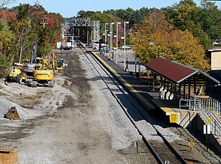
Natick Center station is an MBTA Commuter Rail station in Natick, Massachusetts served by the Framingham/Worcester Line. The station, located below grade in a wide cut adjacent to North Main Street, has two side platforms serving the line's two tracks. The second-busiest non-accessible station on the system, it is undergoing a major accessibility renovation and modernization from 2020 to 2024.

<span class="mw-page-title-main">Lansdowne station (MBTA)</span> Railway station in Boston, Massachusetts, US

Lansdowne station is an MBTA Commuter Rail station in Boston, Massachusetts. It serves the Framingham/Worcester Line. Landsdowne is located next to the Massachusetts Turnpike in the Fenway–Kenmore neighborhood near Kenmore Square, below grade between Beacon Street and Brookline Avenue.

<span class="mw-page-title-main">West Concord station</span> Rail station in Massachusetts, US

West Concord station is an MBTA Commuter Rail station located in West Concord, Massachusetts. It is served by the Fitchburg Line. The station has two side platforms serving the line's two tracks, with mini-high platforms for accessibility. The adjacent station building, now a restaurant, is not used for railroad purposes.

<span class="mw-page-title-main">Ayer station</span> Railway station in Ayer, Massachusetts, US

Ayer station is an MBTA Commuter Rail station located off Main Street in the Ayer Main Street Historic District of Ayer, Massachusetts. It serves the Fitchburg Line. There are three tracks through the station, two of which are served by a pair of low-level side platforms, which are not accessible. There is a shelter on the inbound platform.

<span class="mw-page-title-main">History of the MBTA</span> Story of mass transit in the Boston US area

The history of the Massachusetts Bay Transportation Authority (MBTA) and its predecessors spans two centuries, starting with one of the oldest railroads in the United States. Development of mass transportation both followed existing economic and population patterns, and helped shape those patterns.

<span class="mw-page-title-main">Norfolk station (MBTA)</span> Rail station in Norfolk, Massachusetts, US

Norfolk station is an MBTA Commuter Rail station in Norfolk, Massachusetts, served by the Franklin/Foxboro Line. The station has one platform which serves a single track, with a mini-high section for accessibility. The Norfolk County Railroad opened through the North Wrentham village of Wrentham in 1849. A branch line to Medway was open from 1852 to 1864. The station was renamed Norfolk along with the town in 1870. Several different railroads operated the line, with the New York, New Haven and Hartford Railroad running it for much of the 20th century. Massachusetts Bay Transportation Authority (MBTA) subsidies began in 1966, and the agency bought the line in 1973. The mini-high platform was added in 1990.

<span class="mw-page-title-main">Wellesley Square station</span> Railroad station in Wellesley, Massachusetts, US

Wellesley Square station is a commuter rail station on the MBTA Commuter Rail Framingham/Worcester Line, located just north of the MA 16-MA 135 intersection in downtown Wellesley, Massachusetts. It serves both walk-up and park-and-ride commuters, with a 224-space parking lot for the latter group. The station has low-level platforms and is not accessible.

<span class="mw-page-title-main">West Natick station</span> Railroad station in Natick, Massachusetts, US

West Natick station is a commuter rail station on the MBTA Commuter Rail Framingham/Worcester Line, located off West Central Street (MA-135) in Natick, Massachusetts. It was opened in 1982 as a park and ride station.

<span class="mw-page-title-main">Ashland station (MBTA)</span> Railway station in Ashland, Massachusetts, US

Ashland station is an MBTA Commuter Rail station in Ashland, Massachusetts. It serves the Framingham/Worcester Line. It has a long driveway leading from the south parking lot to the intersection of West Union Street and Voyagers Lane. Like the other stations on the line west of Framingham, Ashland serves as a park-and-ride station with 678 parking spots.

<span class="mw-page-title-main">Southborough station (MBTA)</span> Railroad station in Southborough, Massachusetts

Southborough station is a commuter rail station on the MBTA Commuter Rail Framingham/Worcester Line, located near the intersection of Cordaville Street and River Street in the Cordaville section of Southborough, Massachusetts. The parking area is located off River Street adjacent to the inbound platform. Passengers use ramps and stairways to access the sidewalk along River Street to cross under the tracks.

<span class="mw-page-title-main">Westborough station</span> Train station in Westborough, Massachusetts, US

Westborough station is an MBTA Commuter Rail station in Westborough, Massachusetts. It serves the Framingham/Worcester Line. It is located off Smith Parkway, west of the Westborough town center. The station consists of two side platforms serving the line's two tracks. Each side has a small mini-high platform for accessibility; an overhead ramp structure connects the two platforms.

<span class="mw-page-title-main">North Leominster station</span> Railroad station in Leominster, Massachusetts, US

North Leominster station is an MBTA Commuter Rail station in Leominster, Massachusetts. It serves the Fitchburg Line. It is located at 34 Nashua Street, east of Main Street. The station, which is accessible, has two side platforms to serve the line's two tracks. There is a small freight yard adjacent to the parking lot and mainline tracks on the south end of the inbound platform. A garage opened in 2014 to nearly triple parking capacity at the station, which serves as a park-and-ride stop for Route 2 and I-190, to a total of 436 spaces.

<span class="mw-page-title-main">Fitchburg Intermodal Transportation Center</span> Regional rail and bus station

The Fitchburg Intermodal Transportation Center is a regional rail and bus station located in downtown Fitchburg, Massachusetts. It is a stop on the MBTA Commuter Rail Fitchburg Line and a hub for Montachusett Regional Transit Authority local and intercity bus routes.

<span class="mw-page-title-main">Framingham station</span> MBTA and Amtrak railroad station in Framingham, Massachusetts.

Framingham station is a historic Boston and Albany Railroad station located in downtown Framingham, Massachusetts. Designed by noted American architect H. H. Richardson, it was one of the last of the railroad stations he designed in the northeastern United States to be built. The station, built in 1884–85, served as a major stop on the B&A Main Line as well as a hub for branch lines to Milford, Mansfield, Fitchburg, and Lowell. After years of deterioration, the station was listed on the National Register of Historic Places in 1975 as the Framingham Railroad Station, and restored a decade later.

<span class="mw-page-title-main">Union Station (Worcester, Massachusetts)</span> Railway station in Worcester, Massachusetts, US

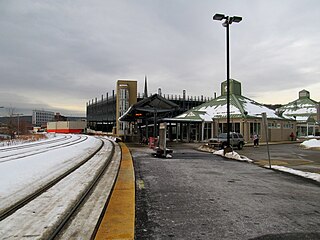
Union Station is a railway station located at Washington Square in downtown Worcester, Massachusetts. It is the western terminus of the MBTA Commuter Rail Framingham/Worcester Line and a stop for the Amtrak Lake Shore Limited service. A bus terminal adjacent to the station is the hub for Worcester Regional Transit Authority (WRTA) local bus service; it is also used by PVTA, Peter Pan, Greyhound intercity buses.

<span class="mw-page-title-main">Newton Corner station</span> Transit hub in Newton, Massachusetts, US

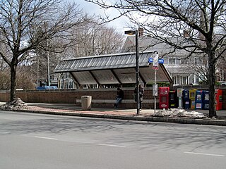
Newton Corner is an MBTA bus transfer point in the Newton Corner neighborhood of Newton, Massachusetts, located on the rotary where Washington Street crosses the Massachusetts Turnpike. The Newton Corner station, known simply as Newton for much of its lifetime, served commuters on the Worcester Line from 1834 to 1959. A streetcar stop, located on the surface streets, served a number of routes beginning in 1863, including the Green Line A branch until 1969. Newton Corner is now a stop and transfer point for MBTA routes 52, 57, 501, 504, 553, 554, 556, and 558, which include express routes to downtown Boston as well as local routes, with stops on the north and south sides of the rotary.

References

  1. 1 2 Belcher, Jonathan. "Changes to Transit Service in the MBTA district" (PDF). Boston Street Railway Association.
  2. Central Transportation Planning Staff (2019). "2018 Commuter Rail Counts". Massachusetts Bay Transportation Authority.
  3. 1 2 Karr, Ronald Dale (2017). The Rail Lines of Southern New England (2 ed.). Branch Line Press. ISBN   9780942147124.
  4. "New England Village". Atlas of Worcester County, Massachusetts. J.B. Beers & Co. 1870 via Ward Maps.
  5. Dickinson, S.N. (1838). The Boston Almanac for the Year 1838. p. 50.
  6. 1 2 3 Humphrey, Thomas J.; Clark, Norton D. (1986). Boston's Commuter Rail: Second Section. Boston Street Railway Association. p. 2. ISBN   9780938315025.
  7. Anderson, Edward A. (July–August 2016). "Worcester Trolleys Remembered Again!". Rollsign. Vol. 53, no. 7/8. Boston Street Railway Association. pp. 3–4.
  8. Roy, John H. Jr. (2007). A Field Guide to Southern New England Railroad Depots and Freight Houses. Branch Line Press. p. 205. ISBN   9780942147087.
  9. Form 2 . New York Central Railroad. April 27, 1941. pp. 7–14 via Wikimedia Commons.
  10. Form 1001 . New York Central Railroad. July 12, 1959. pp. 16, 17 via Wikimedia Commons.
  11. 1 2 Humphrey, Thomas J.; Clark, Norton D. (1985). Boston's Commuter Rail: The First 150 Years. Boston Street Railway Association. p. 24. ISBN   9780685412947.
  12. 1 2 Dodson & Flinker; Brovitz/Community Planning & Design (July 12, 2017). "North Grafton Transit Village Strategic Plan: Final Report" (PDF). Town of Grafton. p. 27.