Gros Islet District

Last updated
Gros Islet
At the top of Pigeon Island.jpg
Gros Islet from Pigeon Island
Gros Islet in Saint Lucia 2014.svg
Location of Gros Islet district within Saint Lucia
Coordinates(Town of Gros Islet): 14°04′N60°56′W / 14.067°N 60.933°W / 14.067; -60.933 (Gros Islet) [1]
Country St. Lucia
Area
[2]
  Total100.3 km2 (38.73 sq mi)
Population
 (2010) [2]
  Total20,872
  Density100.3/km2 (208/sq mi)
ISO 3166-2:LC
LC-06

Gros Islet District, one of 10 first order subdivision (districts, formerly quarters) of the Caribbean island nation of Saint Lucia which includes the island's northernmost point, Cap Point and the notable Cap Estate, where the renowned St. Lucia Golf and Country Club is located. Whilst the town of Gros Islet is an important administrative centre, Rodney Bay is the main financial center of the district.

Contents

History

Pigeon Island Day249apigeonislandk.JPG
Pigeon Island

The Arawak and Carib artifacts found in Gros Islet District date back to around 1000 A.D. [3]

The pirate François Le Clerc, nicknamed Jambe de Bois because of his wooden leg, used Pigeon Island as a base to attack Spanish ships in the 1550s. Peg-Leg Le Clerc was originally from Normandy and the first European to settle Saint Lucia. [4] [5]

Because of the good anchorage at Gros Islet harbor, early French and British sailing ships often anchored at this port city. The French established 47 plantations for producing sugar in Gros Islet by 1775. The Marquis de Bouille captured Gros Islet in 1793 before he was forced to retreat by George Brydges Rodney, 1st Baron Rodney from his base on Pigeon Island. [6]

During World War II, 221 acres of land at Gros Islet were turned into a U.S. Naval Air Station with seaplanes. All that survives today are the cement ramps used by the plane to come on land. [6]

Government

Current Representative for Gros Islet - Kenson Casimir Kenson Casimir.png
Current Representative for Gros Islet - Kenson Casimir

The Gros Islet District is an electoral constituency and has been represented since July 2021 in the House of Assembly of Saint Lucia by Kenson Casimir, Parliamentary Representative for the Gros Islet electoral constituency. [7] [8]

Modern day events

View of Gros Islet from Monchy Gros-Islet St. Lucia.JPG
View of Gros Islet from Monchy

The town of Gros Islet lies north of Castries, the capital of Saint Lucia. Gros Islet is the newest town in Saint Lucia, having been promoted a village to a town in 1985. It is the location of the Darren Sammy National Cricket Stadium where both One Day International and Test Cricket is played. Parts of the 2007 Cricket World Cup and 2010 ICC World Twenty20 were played there.

The town of Gros Islet features a Friday Night Street Party as its major tourist attraction. Also known as the jump-up, the Friday Night Street Party encompasses several blocks, which are informally cordoned off with the stalls of street vendors. Steamed fish, barbecue chicken and St. Lucia's own Piton beer can be purchased from these vendors. Locals and tourist both dance in a central cross section in the small streets to the sounds of calypso, zouk, reggae and R&B. [9]

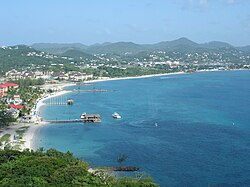
The Rodney Bay area further south differs greatly from the small, makeshift housing littering most of the town of Gros Islet. Catering mostly to the tourism populace, the areas surrounding the marina contain shops, malls, restaurants and night clubs that fall on the higher end of the spectrum compared to other local enterprises. Land development costs in Rodney Bay are extremely high. The exclusive beach front properties have almost all been purchased by small and large hoteliers, and restaurateurs, frustrating locals who continually see access to the public beaches being blocked by large construction projects. [10]

The historic Pigeon Island is a popular place for tourists because of it peacefulness and wildlife. A man-made causeway connects it to the mainland. [11]

Sites of interest

The following sites of interest are in Gros Islet District: [1]

Related Research Articles

<span class="mw-page-title-main">Geography of Saint Lucia</span> Geography of the island country Saint Lucia

Saint Lucia is one of many small land masses composing the insular group known as the Windward Islands. Unlike large limestone areas such as Florida, Cuba, and the Yucatan Peninsula, or the Bahamas, which is a small island group composed of coral and sand, Saint Lucia is a typical Windward Island formation of volcanic rock that came into existence long after much of the region had already been formed.

<span class="mw-page-title-main">Dennery District</span> Quarter and town in St. Lucia

Dennery District is one of 10 districts of the Caribbean island nation of Saint Lucia. The seat of Dennery District is the Dennery Village. The main economic activities are fishing, and the cultivation of lima beans, bananas, and other tropical fruit. The population of the quarter was estimated at 12,876 in 2002 and fell to 12,767 in 2010.

<span class="mw-page-title-main">Anse la Raye District</span> District in Saint Lucia

Anse la Raye District is one of 10 districts of the island nation of St. Lucia in the Caribbean Sea. The name Anse la Raye is French for cover/bay of the rays, since there are a large number of skate fish or rays in the bay. In 2005/2010, the population of the district was 6,382/6,060 people, and they are mainly fishers and agricultural workers. The main town in the area takes the same name as the district and is located down the western coast from Castries, the capital of the country.

<span class="mw-page-title-main">Choiseul District</span> District in St. Lucia

Choiseul District is one of the 10 districts of the Caribbean island nation of Saint Lucia. Located on the southwestern side of the island, the district is home to 6,130 people, according to the 2019 census. The seat of Choiseul District is the town of Choiseul.

<span class="mw-page-title-main">Dauphin Quarter</span> Quarter in Gros Islet, St. Lucia

Dauphin was a Quarter on the Caribbean island nation of Saint Lucia. The district was merged with Gros-Islet in 2014. It contains a village of the same name, located at 14°02′N60°54′W. It was home to Amerindians, the Island Caribs, who settled there. To this day, there are ruins which serve as a reminder of people who lived there long before Christopher Columbus crossed the Atlantic from Europe.

<span class="mw-page-title-main">Micoud District</span> District in St. Lucia

Micoud District is one of 10 districts of the Caribbean island nation of Saint Lucia The seat of this district is the town of Micoud inside this district. According to the 2002 census, the population of the district was 16,143 people. The final 2010 Census recorded a population of 16,284 in Micoud District. A former quarter, Praslin Quarter, was merged into Micoud Quarter. It was not enumerated separately in the 2010 Census. The 2001 Census shows Praslin as part of Micoud District.

<span class="mw-page-title-main">Praslin Quarter</span> Former quarter or district of Saint Lucia

Praslin Quarter was a former quarter on the island nation of Saint Lucia. Since at least 2001, it has been a second-order subdivision of the Micoud District. The 2001 and 2010 Census show Praslin as part of the Micoud District. The population of Praslin is 341.

<span class="mw-page-title-main">Gros Islet</span> Town in Gros Islet Quarter, Saint Lucia

Gros Islet is a community near the northern tip of the island country of Saint Lucia, in the Gros Islet Quarter. Originally a quiet fishing village, it has become one of the more popular tourist destinations in the country.

<span class="mw-page-title-main">Pigeon Island (Saint Lucia)</span> Islet in Saint Lucia; home to the 18th century fortification Fort Rodney

Pigeon Island is a 44-acre (180,000 m2) islet located in Gros Islet in the northern region of Saint Lucia. Once isolated from the country in the Caribbean Sea, the island was artificially joined to the western coast of mainland in 1972 by a man-made causeway built from dirt excavated to form the Rodney Bay Marina. Composed of two peaks the island is a historic site with numerous forts such as an 18th-century British fort and Fort Rodney both used by the British to spy on French Ships from neighbouring Martinique. In 1979 it was named a national park and again in 1992 it became a national landmark under the control of the Saint Lucia National Trust (SLNT). Today, Pigeon Island is the home and major venue of the Saint Lucia Jazz Festival.

<span class="mw-page-title-main">Babonneau</span> Region and electoral district of Saint Lucia

Babonneau is one of the regions of the Caribbean island nation of Saint Lucia. Babonneau is located in the north of the island in the Castries Quarter. There are extensive rain forests in the region, which is an important source of fresh water for Saint Lucia. Babonneau is also an electoral constituency of Saint Lucia represented in the House of Assembly of Saint Lucia, which extends into Gros Islet District.

<span class="mw-page-title-main">Tourism in Saint Lucia</span> Saint Lucia Tourism

Saint Lucia, an island nation in the Caribbean islands, has a relatively large tourism industry. Due to the relatively small land area of the country, most of the governmental promotion is performed by the state-operated Saint Lucia Tourism Authority, led by Executive Chairperson Agnes.

HMS <i>Formidable</i> (1777) Ship of the line of the Royal Navy

HMS Formidable was a 98-gun second rate man-of-war serving the Royal Navy.

<span class="mw-page-title-main">Roseau Valley</span> Place in Anse la Raye, Saint Lucia

The Roseau Valley is a second-order subdivision in the island nation of St. Lucia. It is home to the island's largest banana plantation. The 2010 population of the Roseau Valley was 227.

<span class="mw-page-title-main">Monchy, Saint Lucia</span> Town and administrative division of Gros Islet District, Saint Lucia

Monchy is a town and second-order administrative division of Gros Islet District in the island nation of Saint Lucia. The town is located near the northern end of the island about 4 kilometres (2.5 mi) from Gros Islet, and about 7.9 kilometres (4.9 mi) from the capital, Castries.

<span class="mw-page-title-main">Rodney Bay</span> Bay in Gros Islet Quarter, Saint Lucia

Rodney Bay is a town and bay located in the Gros Islet District on the island of Saint Lucia. Gros Islet is one of the ten districts in the island. It can be found on the northwestern coast of the island above the Castries District, where the capital of St. Lucia is, and the former Dauphin quarter. St. Lucia is a small island in North America located in the Caribbean Sea and it is the largest of the Caribbean's Windward Islands. The Windward islands include Martinique, Saint Vincent and the Grenadines, Barbados, Trinidad and Tobago and Grenada. It is in a chain of islands in the Lesser Antilles with Martinique to the north and Saint Vincent and the Grenadines to the south. These islands are southeast of the islands of Puerto Rico and Haiti. Out of the two airports in St.Lucia, Hewanorra and Charles airport, Rodney Bay is closer to the latter.

The Bois d'Orange River is a river in Gros Islet Quarter, Saint Lucia that flows into the Caribbean Sea.

<span class="mw-page-title-main">Canaries District</span> Quarter or district of the island nation of Saint Lucia

Canaries District is one of 10 districts of the island nation of St. Lucia in the Caribbean Sea. In 2010, the population of the region was 2,009 people, and they are mainly fishers and agricultural workers. The main town in the area takes the same name as the district and is located down the western coast from Castries, the capital of the country. It is the smallest ditrict of Saint Lucia, both by population and area.


Choc Bay is a bay in Gros Islet Quarter on the island nation of Saint Lucia; it is along the northwestern coast of the island. The Choc River flows into the bay.

<span class="mw-page-title-main">Invasion of Tobago</span>

The Invasion of Tobago was a French invasion of the British-held island of Tobago during the Anglo-French War. On May 24, 1781, the fleet of Comte de Grasse landed troops on the island under the command of General Marquis de Bouillé. By June 2, 1781, they had successfully gained control of the island.

References

  1. 1 2 "Gros Islet". Geo Names. Retrieved August 14, 2021.
  2. 1 2 "Map of Gros Islet District" (PDF). Statistical Department of Saint Lucia. Retrieved August 16, 2021.
  3. Devaux, Robert. Pigeon Island National Landmark. The Star Publishing Co. pp. 8–9.
  4. "History and Culture, Saint Lucia". Saint Lucia. Retrieved August 15, 2021.
  5. "Le Clerc Francois". The Ppirate King. Retrieved August 15, 2021.
  6. 1 2 "History of Gros Islet". Saint Lucia History. Retrieved August 14, 2021.
  7. "SLP Wins Landslide Victory In Saint Lucia Elections". St. Lucia Times News. 2021-07-27. Retrieved 2021-08-18.
  8. "Constituences". Saint Lucia Electoral Department. Retrieved 2021-08-18.
  9. Mawer, Fred (2016-02-05). "Where to drink in St Lucia, from swish bars to street parties". The Telegraph. ISSN   0307-1235 . Retrieved 2020-08-03.
  10. HOLAHAN, DAVID. "Visiting St. Lucia: This alluring Windward Island is called the 'most fought-over place on Earth'". courant.com. Retrieved 2020-08-03.
  11. Harmsen, Jolien; Ellis, Guy; Devaux, Robert (2014). A History of St Lucia. Vieux Fort: Lighthouse Road. pp. 49–50. ISBN   9789769534001.