
Shoeburyness, or simply Shoebury, is a coastal town in the City of Southend-on-Sea, in the ceremonial county of Essex, England; it lies 3 miles (5 km) east of the city centre. It was formerly a separate town until it was absorbed into Southend in 1933.

The Essex Wildlife Trust (EWT) is one of 46 wildlife trusts which cover the United Kingdom. The EWT was founded in 1959, and it describes itself as Essex's leading conservation charity, which aims to protect wildlife for the future and the people of the county. As of January 2017, it has over 34,000 members and runs 87 nature reserves, 2 nature parks and 11 visitor centres.

Ingrebourne Valley is a local nature reserve (LNR) in Hornchurch in the London Borough of Havering. It is owned and managed by Havering Council, and has a visitor centre managed by the Essex Wildlife Trust. Most of it is in Hornchurch Country Park west of the River Ingrebourne, but there are also areas north and south of the park which are part of the LNR. It has a wide range of habitats, including woodland, grassland, the river and marshes. It is an important site for a range of species of plants, animals and birds, including great crested newts, slow worms, the harvest mouse and the water vole.

Otmoor or Ot Moor is an area of wetland and wet grassland in Oxfordshire, England, located halfway between Oxford and Bicester. It is about 60 metres (200 ft) above sea level, and has an area of nearly 400 hectares.

Ingrebourne Marshes are a 74.8 hectare biological Site of Special Scientific Interest in Hornchurch in the London Borough of Havering. Ingrebourne Valley Local Nature Reserve includes a small part of the SSSI west of the River Ingrebourne.

Rye Meads is a 58.5-hectare (145-acre) biological Site of Special Scientific Interest (SSSI) in Rye House, Hoddesdon, Hertfordshire. It is one of series of wetlands and reservoirs situated along the River Lea, to the north-east of London. It is part of the Lea Valley Ramsar site and a Special Protection Area.

Frays Farm Meadows is a 28.2-hectare (70-acre) biological Site of Special Scientific Interest near Denham in the London Borough of Hillingdon. It was notified as an SSSI in 1981, and has been managed by the London Wildlife Trust on behalf of Hillingdon Council since 1999. It is part of the Colne Valley Regional Park.

Wangford Warren and Carr is a 67.8-hectare (168-acre) biological Site of Special Scientific Interest between Brandon and Lakenheath in Suffolk. It is a Nature Conservation Review site, Grade I, and part of the Breckland Special Area of Conservation, and Special Protection Area An area of 15 hectares is managed as a nature reserve by the Suffolk Wildlife Trust

Crickley Hill and Barrow Wake is a 56.8-hectare (140-acre) biological and geological Site of Special Scientific Interest in Gloucestershire, notified in 1974.

Hunsdon Mead is a 34 hectare biological Site of Special Scientific Interest (SSSI) west of Harlow and east of Roydon in Essex. The site is partly in Essex and partly in Hertfordshire, and it is jointly owned and managed by the Essex Wildlife Trust and the Herts and Middlesex Wildlife Trust. The SSSI also includes part of the neighbouring Roydon Mead. The planning authorities are East Hertfordshire District Council and Epping Forest District Council. Hunsdon Mead is registered common land.

Totternhoe nature reserve is managed by the Wildlife Trust for Bedfordshire, Cambridgeshire and Northamptonshire (WTBCN). The 31-hectare (77-acre) site is in Totternhoe in Bedfordshire, and it includes parts of three Sites of Special Scientific Interest (SSSIs). Totternhoe Knolls is a biological SSSI owned by Central Bedfordshire Council and leased to the National Trust. Most of it is managed jointly by the National Trust and the WTBCN, excluding Totternhoe Castle, the earthworks of a Norman motte-and-bailey castle which is part of the SSSI but not of WTBCN's nature reserve. Totternhoe nature reserve also includes the geological SSSI, Totternhoe Stone Pit, which is not open to the public, and other areas owned by WTBCN, including part of Totternhoe Chalk Quarry, another biological SSSI.

Dancersend is an 81.3-hectare (201-acre) Site of Special Scientific Interest (SSSI) south of Aston Clinton in Buckinghamshire. Part of the site is managed by the Forestry Commission and part by the Berkshire, Buckinghamshire and Oxfordshire Wildlife Trust (BBOWT). The BBOWT's 47 hectare nature reserve, called Dancersend with Pavis Woods, extends into fields west of the SSSI. It is in the Chilterns Areas of Outstanding Natural Beauty.
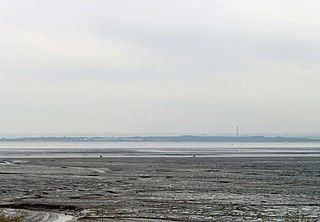
Benfleet and Southend Marshes is an 8.1-square-mile (21 km2) Site of Special Scientific Interest (SSSI) in Essex. It consists of mudflats, salt marshes, scrub and wild grassland, and includes the Southend-on-Sea foreshore. It has been so recognised for its biological value, rather than geological. A definition five percent larger forms the Benfleet and Southend Marshes Ramsar site and Special Protection Area. In the centre-west, more than ten percent of the Site is the Leigh National Nature Reserve (NNR), which has been appraised in detail in A Nature Conservation Review as a site of national importance. The SSSI and NNR include the eastern half of Two Tree Island, in Leigh on Sea which is managed by the Essex Wildlife Trust. A narrow majority of the Site is the Southend on Sea Foreshore Local Nature Reserve.

The Crouch and Roach Estuaries are a 1729 hectare biological Site of Special Scientific Interest (SSSI) at the mouth of the Crouch and Roach rivers in Essex. The Crouch part of the SSSI stretches from near Battlesbridge to Foulness Island, and the Roach from Rochford to the junction with the Crouch. Part of the site is in the Mid-Essex Coast Special Protection Area under the EC Directive on the Conservation of Wild Birds, and a Ramsar wetland site of international importance. It is also part of the Essex Estuaries Special Area of Conservation. An area of 65 hectares is managed by the Essex Wildlife Trust as the Lion Creek and Lower Raypits nature reserve and 8 hectares at Woodham Fen, both of which are managed by the Essex Wildlife Trust. A small area is also a geological SSSI, The Cliff, Burnham-on-Crouch.

Foulness SSSI is a 10,702 hectare biological Site of Special Scientific Interest covering the shoreline between Southend-on-Sea and the Crouch estuary in Essex.

Mill Meadows, Billericay is a 6.7-hectare (17-acre) biological Site of Special Scientific Interest (SSSI) in Billericay in Essex, England. It is part of the 36.8 hectare Mill Meadows Local Nature Reserve (LNR), which is owned and managed by Basildon District Council.

Danish Camp is an Iron Age fortified settlement in Shoeburyness in Essex. It is a Scheduled Monument under the Ancient Monuments and Archaeological Areas Act 1979, list number 1017206. The site is in the Gunners Park and Shoebury Ranges nature reserve, which is managed by the Essex Wildlife Trust.

