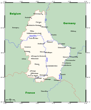
Luxembourg is a small country located in the Low Countries, part of North-West Europe. It borders Belgium for 148 kilometres to the west and north, France (73 km [45 mi]) to the south, and Germany (138 km [86 mi]) to the east. Luxembourg is landlocked, separated from the North Sea by Belgium.

Luxembourg, also known as Luxembourg City, is the capital city of Luxembourg and the country's most populous commune. Standing at the confluence of the Alzette and Pétrusse rivers in southern Luxembourg, the city lies at the heart of Western Europe, situated 213 km (132 mi) by road from Brussels and 209 km (130 mi) from Cologne. The city contains Luxembourg Castle, established by the Franks in the Early Middle Ages, around which a settlement developed.
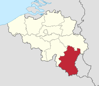
Luxembourg, also called Belgian Luxembourg or West Luxembourg, is the southernmost province of Wallonia within Belgium. It borders the country of Luxembourg to the east, the French departments of Ardennes, Meuse and Meurthe-et-Moselle to the south and southwest, and the Walloon provinces of Namur and Liège to the north. Its capital and largest city is Arlon, in the south-east of the province, near the border of the Grand Duchy of Luxembourg.
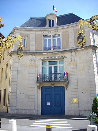
Meurthe-et-Moselle is a département in the Grand Est region of France, named after the rivers Meurthe and Moselle. Its prefecture and largest city is Nancy and it borders the departments of Meuse to the west, Vosges to the south, Moselle and Bas-Rhin and it borders the Belgian province of Luxembourg and the country of Luxembourg by the canton of Esch-sur-Alzette to the north. It had a population of 733,760 in 2019.

Esch-sur-Alzette is a city in the Grand Duchy of Luxembourg and the country's second-most populous commune, with a population of 36,625 inhabitants, as of 2023. It lies in the south-west of the country, on the border with France and in the valley of the Alzette, which flows through the city. The city is usually referred to as just Esch; however, the full name distinguishes it from the village and commune of Esch-sur-Sûre which lies 45 kilometres further north. The country's capital, Luxembourg City, is roughly 15 km (9.3 mi) to the north-east. Esch was selected as the European Capital of Culture for 2022, alongside Kaunas and Novi Sad.

The District of Luxembourg was one of three districts of the Grand Duchy of Luxembourg. It contained four cantons, divided into 44 communes:
- Capellen
- Esch-sur-Alzette
- Luxembourg
- Mersch

The Alzette is a river with a length of 73 kilometres (45 mi) in France and Luxembourg. It is a right tributary of the Sauer, and ultimately to the Rhine.
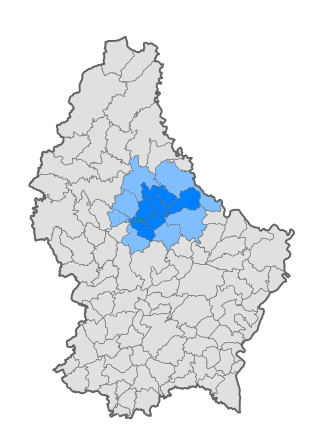
The 12 cantons of the Grand Duchy of Luxembourg are subdivisions at the first level of local administrative unit (LAU-1) in the European Union's Nomenclature of Territorial Units for Statistics for Eurostat purposes. They were subdivisions of the three districts of Luxembourg until 2015, when the district level of government was abolished. The cantons are in turn subdivided into 100 communes.

Redange is a canton in the northwest of Luxembourg. Its namesake commune is Redange, officially known as Redange-sur-Attert. It borders the cantons of Wiltz to the north, Diekirch and Mersch to the east, Capellen to the south and Belgium to the west.

Esch-sur-Alzette is a canton in southwestern Luxembourg. It is both the second most populous and second most densely populated canton after the canton of Luxembourg. It borders Belgium & France.

Luxembourg's 100 communes conform to LAU Level 2 and are the country's lowest administrative divisions.
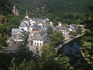
Esch-sur-Sûre is a commune and small town in north-western Luxembourg. It is part of the canton of Wiltz, which is part of the district of Diekirch. At one point it was the second smallest commune by area in Luxembourg, until Neunhausen and Heiderscheid were merged into it in 2011.

Pétange is a commune and town in south-western Luxembourg. It is part of the canton of Esch-sur-Alzette and is the fifth-most populous commune in Luxembourg, as well as the most populous without town status. Pétange lies at the borders with both Belgium and France.

Schifflange is a commune and town in south-western Luxembourg. It is part of the canton of Esch-sur-Alzette.
The Éislek, also known by its German name Ösling or Oesling, is a region covering the northern part of both the Grand Duchy of Luxembourg and Eifelkreis Bitburg-Prüm, within the greater Ardennes area that also covers parts of Belgium and France. The Éislek covers 32% of the territory of Luxembourg; to the south of the Éislek lies the Gutland, which covers the remaining 68% of the Grand Duchy as well as the southern part of the Eifelkreis Bitburg-Prüm.
Nordstad is a development area in north-central Luxembourg, and a colloquial term to refer to the combined urban areas in the region. The name is Luxembourgish for 'northern city', but it remains the title, both formal and informal, of the region in any language.
The Red Lands form a geographic region in southern and south-western Luxembourg. They are so called for their red iron-laden earth. The Red Lands roughly correspond with the southern part of the canton of Esch-sur-Alzette, along the border with France. Geologically, the Red Lands are sedimentary, mostly sandstones and conglomerates, formed in the Middle Jurassic epoch.

The history of the Jews in Luxembourg dates back to the 1200s. There are roughly 1,200 Jews in Luxembourg, and Jews form one of the largest and most important religious and ethnic minority communities in Luxembourg historically.

Esch-sur-Alzette railway station is a railway station serving Esch-sur-Alzette, in south-western Luxembourg. It is operated by Chemins de Fer Luxembourgeois (CFL), the state-owned railway company. CFL general refer to the station as Esch/Alzette as shown on the sign.

Tageblatt is a German language daily newspaper published in Esch-sur-Alzette, Luxembourg by Editpress.
