Hackleburg, Alabama

Last updated

Hackleburg, Alabama
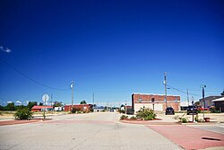
Hackleburg-street-north-al.jpg
Main Street
Marion County Alabama Incorporated and Unincorporated areas Hackleburg Highlighted 0132560.svg
Location in Marion County, Alabama
Coordinates: 34°16′17″N87°49′50″W / 34.27139°N 87.83056°W / 34.27139; -87.83056
Country United States
State Alabama
County Marion
Area
[1]
  Total15.29 sq mi (39.6 km2)
  Land15.28 sq mi (39.6 km2)
  Water0.01 sq mi (0.03 km2)
Elevation
938 ft (286 m)
Population
 (2020) [2]
  Total1,425
  Density93.29/sq mi (36.02/km2)
Time zone UTC-6 (Central (CST))
  Summer (DST) UTC-5 (CDT)
ZIP code
35564
Area code(s) 205, 659
FIPS code 01-32560
GNIS feature ID0119530
Website townofhackleburg.com

Hackleburg is a town in Marion County, Alabama, United States. It incorporated on August 23, 1909. [3] At the 2020 census, its population was 1,425, [2] down from 1,516 at the 2010 census.

Contents

History

Hackleburg developed in the early 19th century as a stop along Jackson's Military Road. It was named by the early drovers of sheep who passed through the region while en route to market in Tuscumbia, and whose sheep encountered a thorny plant growing in abundance in that area and known locally by the name hack burrs (often corrupted to "hack berries") and which same plants were often fatal to sheep, besides being destructive to their wool. [4] A post office opened in the town in 1885. [3]

Hackleburg incorporated in 1909 following the construction of a branch line of the Illinois Central Railroad through the area. [3] Hackleburg marks the highest point (some 931 feet above sea level) along the route connecting Miami, Florida with Chicago, Illinois. [4]

2011 tornado

On April 27, 2011, Hackleburg suffered catastrophic damage when it was hit by an EF5 tornado part of the 2011 Super Outbreak. Eighteen Hackleburg residents died in the storm. [5] [6] On May 2, the Red Cross declared the city 75 percent destroyed. [7] Many people rebuilt here, although 2017 population estimates showed a slight decline from 2010.

Geography

Hackleburg is located in northern Marion County at 34°16′17″N87°49′51″W / 34.27139°N 87.83083°W / 34.27139; -87.83083 . [8] U.S. Route 43 and Alabama State Route 172 intersect in the center of town. US 43 connects the town with Russellville 18 miles (29 km) to the north and Hamilton, the Marion county seat, 14 miles (23 km) to the southwest.

Dismals Canyon, a National Natural Landmark, is located 4 miles (6 km) northeast of Hackleburg. According to the U.S. Census Bureau, the town has a total area of 15.3 square miles (40 km2), of which 0.01 square miles (0.03 km2), or 0.07%, are water. [1] The town center is on the Tennessee Valley Divide (watershed), with half of the town draining north toward Bear Creek, a tributary of the Tennessee River, and half draining south to tributaries of Clifty Creek, part of the Tombigbee River basin. [4]

Demographics

Historical population
CensusPop.Note
1910 286
1920 37631.5%
1930 62867.0%
1940 492−21.7%
1950 5348.5%
1960 527−1.3%
1970 72637.8%
1980 88321.6%
1990 1,16131.5%
2000 1,52731.5%
2010 1,516−0.7%
2020 1,425−6.0%
U.S. Decennial Census [9]

2000 census

At the 2000 census there were 1,527 people, 657 households, and 444 families in the town. The population density was 99.7 inhabitants per square mile (38.5/km2). There were 737 housing units at an average density of 48.1 per square mile (18.6/km2). The racial makeup of the town was 99.21% White, 0.13% Black or African American, 0.07% Native American, 0.07% from other races, and 0.52% from two or more races. 0.26% of the population were Hispanic or Latino of any race. [10] Of the 657 households 28.9% had children under the age of 18 living with them, 54.3% were married couples living together, 9.6% had a female householder with no husband present, and 32.4% were non-families. 29.5% of households were one person and 16.6% were one person aged 65 or older. The average household size was 2.32 and the average family size was 2.88.

The age distribution was 23.2% under the age of 18, 7.3% from 18 to 24, 27.1% from 25 to 44, 25.7% from 45 to 64, and 16.6% 65 or older. The median age was 40 years. For every 100 females, there were 90.4 males. For every 100 females age 18 and over, there were 89.3 males.

The median household income was $26,075 and the median family income was $30,938. Males had a median income of $26,542 versus $20,739 for females. The per capita income for the town was $17,239. About 10.8% of families and 14.8% of the population were below the poverty line, including 13.2% of those under age 18 and 25.8% of those age 65 or over.

2010 census

At the 2010 census there were 1,516 people, 656 households, and 433 families in the town. The population density was 99.8 inhabitants per square mile (38.5/km2). There were 769 housing units at an average density of 50.3 per square mile (19.4/km2). The racial makeup of the town was 97.7% White, 0.1% Black or African American, 0.2% Native American, 1.0% from other races, and 1.1% from two or more races. 1.3% of the population were Hispanic or Latino of any race. [11]

Of the 656 households 26.1% had children under the age of 18 living with them, 50.3% were married couples living together, 11.9% had a female householder with no husband present, and 34.0% were non-families. 30.5% of households were one person and 17.7% were one person aged 65 or older. The average household size was 2.31 and the average family size was 2.83.

The age distribution was 20.5% under the age of 18, 8.8% from 18 to 24, 21.1% from 25 to 44, 28.4% from 45 to 64, and 21.1% 65 or older. The median age was 44.7 years. For every 100 females, there were 89.3 males. For every 100 females age 18 and over, there were 89.5 males.

The median household income was $29,350 and the median family income was $34,375. Males had a median income of $27,426 versus $24,625 for females. The per capita income for the town was $16,584. About 27.4% of families and 31.1% of the population were below the poverty line, including 51.3% of those under age 18 and 18.5% of those age 65 or over.
2020 census

Hackleburg racial composition [12]
RaceNum.Perc.
White (non-Hispanic)1,31592.28%
Black or African American (non-Hispanic)40.28%
Native American 30.21%
Asian 40.28%
Other/Mixed 473.3%
Hispanic or Latino 523.65%

As of the 2020 United States census, there were 1,425 people, 536 households, and 344 families residing in the town.

Education

Hackleburg is a part of the Marion County Schools district.

Hackleburg Elementary and High School's mascot is the Panther, and the school colors are Black and Gold. The schools were among the many buildings destroyed by the tornado of April 27, 2011.

The Marion County Board of Education initiated construction of a $25 million total K-12 academic complex in Hackleburg. It opened for the 2015–2016 school year.

Athletics

The 2003 and the 2004 Hackleburg High School baseball teams finished as runners-up in the Alabama High School Athletic Association state baseball tournament. The 2007 Hackleburg High School baseball team won the 1A State Championship in the Alabama High School Athletic Association state baseball tournament. It marked the first state championship in the school's history. [13] In December 2009 the High School football team became 1A State runners-up in the AHSAA football championship losing to the Brantley Bulldogs. [14]

Notable people

Related Research Articles

<span class="mw-page-title-main">Franklin County, Alabama</span> County in Alabama, United States

Franklin County is a county located in the U.S. state of Alabama. As of the 2020 census, the population was 32,113. Its county seat is Russellville. Its name is in honor of Benjamin Franklin, famous statesman, scientist, and printer. It is a dry county, although the city of Russellville is wet.

<span class="mw-page-title-main">Marion County, Alabama</span> County in Alabama, United States

Marion County is a county of the U.S. state of Alabama. As of the 2020 census the population was 29,341. The county seat is Hamilton. The county was created by an act of the Alabama Territorial General Assembly on February 13, 1818. The county seat was originally established in Pikeville in 1820, and moved to Hamilton in 1881. The county was named by planter and US Indian agent John Dabney Terrell, Sr., in recognition of General Francis Marion of South Carolina.

<span class="mw-page-title-main">Walker County, Alabama</span> County in Alabama, United States

Walker County is a county located in the central portion of the U.S. state of Alabama. As of the 2020 census, the population was 65,342. Its county seat is Jasper. Its name is in honor of John Williams Walker, the first U.S. senator elected from Alabama.

<span class="mw-page-title-main">Castleberry, Alabama</span> Town in Alabama, United States

Castleberry is a town in Conecuh County, Alabama, United States. At the 2020 census, the population was 486. Castleberry is known as the "Strawberry Capital of Alabama" and is home to the annual Castleberry Strawberry Festival. Castleberry is also known for its "speed trap" with the confiscation of property happening on a regular basis. The town has five police officers. A lawsuit against former Police Chief Tracy Hawsey and the town of Castleberry is pending. According to one source, "Lawsuits allege that Brookside police officers made up charges to soak vehicle owners for thousands of dollars in fines."

<span class="mw-page-title-main">Glen Allen, Alabama</span> Town in Alabama, United States

Glen Allen is a town located in Fayette and Marion counties in the U.S. state of Alabama. The town incorporated in May 1959. At the 2020 census, the population was 433, down from 510 at the 2010 census. Glen Allen is positioned along the BNSF railway and is near Interstate 22, providing access to multiple expanding industries.

<span class="mw-page-title-main">Hodges, Alabama</span> Town in Alabama, United States

Hodges is a town in Franklin County, Alabama, United States. At the 2020 census, the population was 265. Hodges was laid out in 1902. It was incorporated in 1913.

<span class="mw-page-title-main">Moundville, Alabama</span> Town in Alabama, United States

Moundville is a town in Hale and Tuscaloosa counties in the U.S. state of Alabama. It was incorporated on December 22, 1908. From its incorporation until the 1970 census, it was wholly within Hale County. At the 2010 census the population was 2,427, up from 1,809 at the 2000 census. It is part of the Tuscaloosa Metropolitan Statistical Area. Within the town is Moundville Archaeological Site, the location of a prehistoric Mississippian culture political and ceremonial center.

<span class="mw-page-title-main">Dutton, Alabama</span> Town in Alabama, United States

Dutton is a town in Jackson County, Alabama, United States. It was incorporated in 1963. As of the 2010 census, the population of the town was 315, up from 310 in 2000. Dutton is located atop Sand Mountain.

<span class="mw-page-title-main">Pisgah, Alabama</span> Town in Alabama, United States

Pisgah is a town in Jackson County, Alabama, United States, and is included in the Huntsville-Decatur Combined Statistical Area. It incorporated in 1947. As of the 2020 census, the population of the town was 681, down from 722 in 2010. Pisgah is located atop Sand Mountain.

<span class="mw-page-title-main">Anderson, Alabama</span> Town in Alabama, United States

Anderson is a town in Lauderdale County, Alabama, United States. It is part of the Florence - Muscle Shoals Metropolitan Statistical Area known as "The Shoals". As of the 2010 U.S. Census, the town had a population of 282, down from 354 in 2000.

<span class="mw-page-title-main">Town Creek, Alabama</span> Town in Alabama, United States

Town Creek is a town in Lawrence County, Alabama, United States, and is included in the Decatur Metropolitan Area, as well as the Huntsville-Decatur Combined Statistical Area. It incorporated in March 1875. As of the 2010 census, the population of the town is 1100, down from 1216 in 2000. Since 1920, it has been the second largest town in Lawrence County after Moulton.

<span class="mw-page-title-main">New Market, Alabama</span> Census-designated place in Alabama, United States

New Market is an unincorporated community and census-designated place (CDP) in Madison County, Alabama, United States, and is included in the Huntsville-Decatur Combined Statistical Area. As of the 2020 census, the population of the CDP was 1,543. Although it was the first area settled in Madison County, the town has never been incorporated.

<span class="mw-page-title-main">Bear Creek, Alabama</span> Town in Alabama, United States

Bear Creek is a town in Marion County, Alabama, United States. It incorporated in 1907, although the 1910 U.S. Census records indicated 1909. At the 2020 census, the population was 1,047.

<span class="mw-page-title-main">Guin, Alabama</span> City in Alabama, United States

Guin is a city in Marion County, Alabama, United States. It incorporated in December 1889. At the 2020 census, the population was 2,195.

<span class="mw-page-title-main">Haleyville, Alabama</span> City in Alabama, United States

Haleyville is a city in Winston and Marion counties in the U.S. state of Alabama. It incorporated on February 28, 1889. Most of the city is located in Winston County, with a small portion of the western limits entering Marion County. Haleyville was originally named "Davis Cross Roads", having been established at the crossroads of Byler Road and the Illinois Central Railroad. At the 2020 census the population was 4,361, up from 4,173 at the 2010 census.

<span class="mw-page-title-main">Lake View, Alabama</span> City in Alabama, United States

Lake View is a city in Alabama, United States, with the majority in Tuscaloosa County and with a small portion in Jefferson County. At the 2010 census the population was 1,943, up from 1,357 in 2000. It is part of the Tuscaloosa Metropolitan Statistical Area and the Birmingham metropolitan area. It is located approximately halfway between Tuscaloosa and Birmingham via Interstates 20 and 59.

<span class="mw-page-title-main">Sipsey, Alabama</span> Town in Alabama, United States

Sipsey is a town in Walker County, Alabama, United States. At the 2010 census the population was 437, down from 552.

<span class="mw-page-title-main">Double Springs, Alabama</span> City in and county seat of Winston County, Alabama

Double Springs is a town in Winston County, Alabama, United States. The city is the county seat of Winston County. The county seat was initially located at Houston, but by referendum in 1883, Double Springs prevailed and it was removed to there. It was incorporated on May 17, 1943. At the 2010 census the population was 1,083, up from 1,003 in 2000.

<span class="mw-page-title-main">Lynn, Alabama</span> Town in Alabama, United States

Lynn is a town in Winston County, Alabama, United States. It incorporated in April 1952. At the 2020 census the population was 832. Up from the 2010 census (659) up from 597 in 2000.

<span class="mw-page-title-main">Sunset, Arkansas</span> Town in Arkansas, United States

Sunset is a town in Crittenden County, Arkansas, United States. The population was 198 at the 2010 census.

References

  1. 1 2 "2021 U.S. Gazetteer Files". United States Census Bureau. Retrieved April 14, 2022.
  2. 1 2 "Hackleburg town, Alabama: 2020 DEC Redistricting Data (PL 94-171)". U.S. Census Bureau. Retrieved April 14, 2022.
  3. 1 2 3 Christopher Maloney, "Hackleburg," Encyclopedia of Alabama, July 16, 2018.
  4. 1 2 3 The Heritage of Marion County, Alabama (2 ed.). Clanton, Al.: Heritage Publishing Consultants, County Heritage, & The Marion County Heritage. 2000. p. 17. ISBN   1-891647-28-8.
  5. "Alabama storm death toll at 238". Montgomery Advertiser. www.montgomeryadvertiser.com. May 12, 2011. Retrieved May 13, 2011.
  6. Sentell, Jeff (May 12, 2011). "Hackleburg baseball team loses in quarterfinals, but tornado ravaged town's spirit still soars". al.com. www.al.com. Retrieved May 13, 2011.
  7. Ott, Tanya (May 3, 2011). "In Small Towns Hit By Twisters, 'You Feel Ignored'". NPR. Retrieved May 3, 2011.
  8. "US Gazetteer files: 2010, 2000, and 1990". United States Census Bureau. February 12, 2011. Retrieved April 23, 2011.
  9. "U.S. Decennial Census". Census.gov. Retrieved June 6, 2013.
  10. "U.S. Census website". United States Census Bureau . Retrieved January 31, 2008.
  11. "U.S. Census website". United States Census Bureau . Retrieved August 3, 2015.
  12. "Explore Census Data". data.census.gov. Retrieved December 11, 2021.
  13. "Perfect Ending". The Times Daily. June 16, 2007. Retrieved April 12, 2010.
  14. "Brantley snuffs Hackleburg's title hopes". al.com. December 4, 2009. Retrieved April 12, 2010.
  15. Siebenthaler, Donna J. "Marion County". Encyclopedia of Alabama. Retrieved November 27, 2021.

34°16′17″N87°49′51″W / 34.27146°N 87.830826°W / 34.27146; -87.830826