on the southwest and northwest within CFB Gagetown by a line at the end of Olinville Road and running[a] along Yorkshire Road to the northwestern line of a grant to John Short, east of the junction with the road to Vincent, then northeasterly and northwesterly along grants belonging to Sylvanus Haviland, James Corbett, and Henry Appleby to the Lawfield Road, then northeasterly along Lawfield Road to the southernmost corner of a grant to Thomas T. Hewlett at the corner of Kerr Road, meeting a line running south 52º west,[b] from the southwestern corner of a grant to Nathaniel Jarvis, then following the line out of CFB Gagetown;
on the north by the southern line of the Jarvis grant, part of which forms the southern boundary of the village of Gagetown;
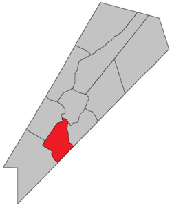
including Spoon Island, Upper Musquash Island, and the western half of Long Island.
Communities
Communities at least partly within the parish;[9][10][11]bold indicates an incorporated municipality; italics indicate a community expropriated for CFB Gagetown
↑Roads still appear on cadastral maps but not in highway mapbooks; because the old roads and grants are used in the Territorial Division Act they're used here.
↑By the magnet of 1850,[12] when declination at the starting point was about 18º 20' west of north.[13] The Territorial Division Act clause referring to magnetic direction bearings was omitted in the 1952[14] and 1973 Revised Statutes.[2]
↑"57 Vic. c. 35 An Act to change the boundaries of the Parishes of Wickham and Hampstead, in the County of Queen's.". Acts of the General Assembly of Her Majesty's Province of New Brunswick. Passed in the Month of April, 1894. Fredericton: Government of New Brunswick. 1894. pp.160–161. Available as a free ebook from Google Books.
12345"No. 138". Provincial Archives of New Brunswick. Department of Natural Resources and Energy Development. Retrieved 19 June 2021. Remainder of parish on maps 139, 148, and 149 at same site.
12345"412"(PDF). Transportation and Infrastructure. Government of New Brunswick. Retrieved 19 June 2021. Remainder of parish on mapbooks 429, 430, 444, and 445 at same site.
↑"13 Vic. c. 51 An Act to consolidate all the Laws now in force for the division of the Province into Counties, Towns and Parishes.". Acts of the General Assembly of Her Mjaesty's Province of New Brunswick, Passed in the Year 1850. Fredericton: Government of New Brunswick. 1850. pp.142–152, 145–149. Book was poorly proofread, resulting in title typo and reuse of page numbers 145–152.
↑"Chapter 227 Territorial Division Act". The Revised Statutes of New Brunswick 1952 Volume III. Fredericton: Government of New Brunswick. 1952. pp.3725–3771.
This page is based on this Wikipedia article Text is available under the CC BY-SA 4.0 license; additional terms may apply. Images, videos and audio are available under their respective licenses.