
Graeagle is a census-designated place (CDP) located about 60 miles (97 km) from Reno, Nevada and 46 miles (74 km) from Truckee, California in Plumas County, California, United States. The population was 737 at the 2010 census, down from 831 at the 2000 census.

La Porte is a census-designated place (CDP) in Plumas County, California, United States. The population was 26 at the 2010 census, down from 43 at the 2000 census.

The Feather River is the principal tributary of the Sacramento River, in the Sacramento Valley of Northern California. The river's main stem is about 73 miles (117 km) long. Its length to its most distant headwater tributary is just over 210 miles (340 km). The main stem Feather River begins in Lake Oroville, where its four long tributary forks join together—the South Fork, Middle Fork, North Fork, and West Branch Feather Rivers. These and other tributaries drain part of the northern Sierra Nevada, and the extreme southern Cascades, as well as a small portion of the Sacramento Valley. The total drainage basin is about 6,200 square miles (16,000 km2), with approximately 3,604 square miles (9,330 km2) above Lake Oroville.
Sierra Valley is a large mountain valley located west of the crest of California's Sierra Nevada mountain range in Plumas and Sierra Counties, north of Interstate 80.
.Allison Lake Provincial Park is a provincial park in British Columbia, Canada, located 28 kilometres north of Princeton, British Columbia. The park, which is 23 ha. in size, was established July 26, 1960. It is mainly a recreation area, offering camping, swimming and fishing. The park contains mostly aspen.
Cariboo River Provincial Park is a provincial park in British Columbia, Canada, located between Barkerville and Likely in the upper Cariboo River basin.

Canim Beach Provincial Park is a provincial park in British Columbia, Canada, located at the southwest end of Canim Lake in the Interlakes District of the South Cariboo region, adjacent to the Secwepemc Indian reserve community of Canim Lake, British Columbia just northeast of 100 Mile House. The park was established by Order-in-Council in 1956 and expanded by later legislation in 2000 and 2004 to total a current approximate of 8.2 hectares.

The Williams Loop is a rail spiral located on the Union Pacific Railroad's Feather River Route through the Sierra Nevada mountains in northeastern California, connecting the Sacramento Valley to Salt Lake City via the Feather River canyons. Located approximately five miles east of East Quincy, the loop is used to gain elevation on the WP's eastward climb to its summit at Beckwourth Pass while maintaining the railroad's overall 1.0 percent (compensated) grade, the least steep of any grade on a transcontinental railroad. More specifically, the loop helps the railroad to surmount the divide between the East Branch North Fork Feather River and the Middle Fork Feather River.
The Elephants Playground is a rock formation located in Genesee, Plumas County, California.
Kwikwasut'inuxw Haxwa'mis, formerly the Kwicksutaineuk-ah-kwa-mish First Nation is a First Nations band government based on northern Vancouver Island in British Columbia, Canada, in the Queen Charlotte Strait region. It is a member of the Musgamagw Tsawataineuk Tribal Council, along with the ‘Namgis First Nation and the Tsawataineuk First Nation. The Kwikwasut'inuxw and Haxwa'mis are two of the many subgroups of the peoples known as Kwakwaka'wakw, which means "speakers of Kwak'wala", their language, and were combined into one band by the Department of Indian and Northern Affairs.
Sanghoi is a village and union council of Jhelum District in the Punjab Province of Pakistan. It is part of Jhelum Tehsil. and is located at 32°52'0N 73°36'0E with an altitude of 223 metres (734 feet).
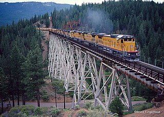
The Clio Trestle is a railroad trestle on the historic Feather River Route of the Union Pacific Railroad. It is located in the Sierra Nevada near Clio in Plumas County, California. The trestle is 172 feet (52 m) high and 1,005 feet (306 m) long.
The Spring Garden Tunnel at 7,344 ft (2,238 m) in Spring Garden, California is the longest of 34 tunnels on the Feather River Route and crosses under the drainage divide between the East Branch North Fork Feather River and the Middle Fork Feather River.

Happy Valley is an unincorporated community in Calaveras County, California. It lies at an elevation of 1509 feet.
Plumas is a former settlement in Yuba County, California. It was located 1.25 miles (2.0 km) south-southeast of Arboga on the Sacramento Northern Railroad.

Plumas Landing is a former settlement in Yuba County, California. It was located on Feather River, 9 miles (14 km) south of Marysville.
Ittel is a populated place in the Trier-Saarburg district of the Rhineland-Palatinate state in Germany.
Nelson Point is a former settlement originally created in the Quartz Township of Butte County, California, which later became Plumas County, California. It was a thriving Gold Rush era mining camp, and one of the largest and most important communities in the region.
Onion Valley, California is located at 39.78916769999999°N 120.86949950000002°W near Onion Valley Creek in Plumas County.


