Harnham is a suburb of the city of Salisbury in Wiltshire, England, centred about 0.6 miles (1 km) south of Salisbury Cathedral and across the River Avon. Harnham is split into the areas of West Harnham and East Harnham.
The area has had human habitation since the Iron Age; a settlement is marked on Ordnance Survey maps underneath several modern houses in Harnwood Road / Old Blandford Road, a straight Roman road. [n 1] [2]
Until the 19th-century formation of urban and rural districts, the area lay within the Cawdon and Cawsworth Hundred of Wiltshire. [3]
Road access to the city was improved in 1244 by the building of Ayleswade bridge, in two sections across an island in the Avon, leading traffic from the south through Harnham instead of the older route to the west through Wilton. [4] The old bridge survives inside an outer casing added in the 16th or 17th century. [5]
St Nicholas Hospital, sometimes described as being in Harnham, [6] was built earlier than the bridge, just north of it. [7] [8] Parts of the medieval almshouses survive, including two chapels, [9] and the site continues to provide sheltered housing for a Christian community. [10]
The manors of East and West Harnham were still owned by the 13th-century College of the Valley Scholars, which stood next to St Nicholas Hospital, when it was dissolved in 1542. The next year, they were sold by the Crown to Sir Michael Lister, a king's servant. [11]
In 1848, Samuel Lewis (publisher) described the settlement in a topographical dictionary based partly on 1841 census statistics:
East Harnham was anciently a tithing in the parish of Britford. It became an ecclesiastical parish in 1855 after the opening of All Saints' church. [13] East Harnham continued to be part of Britford civil parish until 1896, when it was made a separate civil parish. In 1904 the civil parish of East Harnham was abolished. Most of its area, including the village itself, was absorbed into the borough boundaries of Salisbury; the more rural parts of the old East Harnham parish were split between neighbouring Britford and West Harnham. [14] [4] [15] A Harnham civil parish briefly existed between 1904 and 1905 covering the parts of East Harnham and Britford which had been transferred into the borough of Salisbury in 1904; as an urban parish it had no parish council and was always directly administered by the city council. All the urban parishes within Salisbury were united into a single parish called New Sarum in 1905. [16]
West Harnham was anciently a chapelry in the parish of Coombe Bissett, but was treated as a separate civil parish from an early date. [16] The boundary with neighbouring Netherhampton to its west was the course of a Roman road. [17] In 1927 the urban part of West Harnham was transferred into the borough of Salisbury. A residual parish of West Harnham just covering the rural parts of the old parish continued to exist until 1934 when it was abolished and absorbed into Netherhampton. [18]
Harnham is a suburb in the southwest of Salisbury and is linked to the city by road via the Ayleswade Bridge in East Harnham, originally built across the Avon in 1244, and by foot via the Town Path across the "historic and important landscape" [19] of the Harnham Water Meadows in West Harnham.
The meadows lie between two branches of the River Nadder and extend into the outskirts of the city. They are part of an extensive irrigation system of floated water meadows, dating from the mid-seventeenth century. Now a Site of Special Scientific Interest known as East Harnham Meadows, they are still used for grazing and were voted the Best View in Britain by Country Life magazine in 2002.[ citation needed ] The meadows were made famous in John Constable's painting "Salisbury Cathedral – A View from the Water Meadow". The meadows are managed by the Harnham Water Meadows Trust, and owned by the Trust jointly with the Dean and Chapter of Salisbury Cathedral. [20]
In the 13th century, Salisbury sited its new Cathedral on the flat fertile plain encircled by the Avon and protected by Harnham Hill, a chalk escarpment which rises steeply to the south. Harnham Slope comprises an area of woodland on the northern slope of Harnham Hill, including the West Harnham Chalk Pit, a 2.8 hectares (6.9 acres) geological Site of Special Scientific Interest. The upper slope is now managed as a public amenity space which, from its highest point, offers views across Harnham to the city, including the cathedral's spire.
In 2012, Harnham was the suburb of the city with the largest area of housing valued at more than £400,000. [21]
East Harnham is centred on a busy roundabout and is 0.8 miles south-south west of Salisbury city centre. The roundabout is one end of the A3094 to Quidhampton and is also the intersection of the A338 and the A354. Attractions in the area include Salisbury Lawn Tennis Club, Bishop Wordsworth's school playing fields and the River Avon which separates it from the rest of Salisbury. The suburb is near the Britford park and ride site, where regular Salisbury Reds bus services connect the area to the city centre.
West Harnham is an outer suburb of Salisbury, bisected by the A3054/Netherhampton Road, and is north-west of Old Blandford Road. [22] The suburb is home to the Harnham trading estate as well as the local water meadows. West Harnham was incorporated into the city after East Harnham, being further from the city centre.
The first tier of local government is Salisbury City Council, established in 2009 upon the abolition of Salisbury District. Harnham is split into two electoral divisions for local elections: Harnham East (comprising most of East Harnham, as well as the Close and the Friary) and Harnham West (comprising West and part of East Harnham). [23] Each elects one member of the Wiltshire Council unitary authority [24] and three city councillors. [25]
Prior to redistricting for the 2021 local elections, Harnham ward, with three councillors, used to cover most of the area although the streets north of the Netherhampton Road were in the St Martin's & Cathedral ward. [26] The ward elected one councillor to Wiltshire Council. [27]
In 1881 the long-standing church at West Harnham – previously a chapelry of Coombe Bissett, two miles to the south – was united with the newer church at East Harnham. [28] Since 1972, the name of the parish is 'St. George and All Saints Harnham' [29] [30] and both churches are part of the same Christian community. [31]
It is certain that the West Harnham church was built or re-built by 1115, the date when King Henry I signed a charter granting certain churches to Salisbury Cathedral, including the church at Harnham. [32] A mid-12th-century door survives in the north wall of the nave; the font bowl is also from that century. [33] The chancel was lengthened in the "E.E. style" (i.e. during the 13th century), and probably in the early 14th century the Trinity Chapel on the south side was built. [32]
St George's had some remodelling c1300, and 1300–30 is the indicated date of the south chapel; its tower mostly early 19th century, probably on the site of an earlier tower. William Butterfield led its careful restoration (1873–4). He was responsible in the 1850s for the great church of All Saints, Margaret Street, London which broke new ground in its use of brick and of extensive polychromy detailing. The church was designated as Grade II* listed in 1952. [32]
T.H. Wyatt designed the small All Saints church at East Harnham, completed in 1854. [34] The work was paid for by Isabella Lear, widow of Francis Lear, in memory of her husband who had been Dean of Salisbury. [35] Previously part of Britford parish, a new parish was created for All Saints in 1855. [36]
A small Methodist church was built in Saxon Road in 1952, closed in the 1980s and later demolished. [37]
The 1244 bridge over the Avon is Grade I listed. [5]
Dating from the 12th century, this Grade I listed building [38] in the lower part of West Harnham has details around its doors and windows from 1250. The building was converted in the 16th century from ecclesiastical use to Wiltshire's first paper mill, when the River Nadder was diverted to flow under it.
In the early 20th century, the property was converted into a country club by Mary Fox-Pitt, daughter-in-law of Augustus Pitt Rivers. The atmosphere was praised by the food writer Florence White, author of Good Things in England (1932). She quotes the artist Augustus John saying "It is the best cookery in England." [39]
The building is now a hotel and the mill race can still be seen from its restaurant.
Rose and Crown Terrace is the largest of the listed buildings in East Harnham; nos 53-61 are listed and all but one have thatched roofs; the style is formal early 19th century Regency. [40]
Two schools share one site: Harnham Infant School (ages 4 to 7) and Harnham CofE Junior School (7 to 11).
Recreational amenities include path-laid riverside walks, a thriving lawn tennis club and pitches for both local cricket and football clubs.
There is accommodation at a number of local hotels and bed & breakfasts, making the area popular with both UK and overseas visitors. As well as the Old Mill, local pubs include The Rose and Crown (hotel) and The Grey Fisher.
Harnham Social Club is adjacent to the football pitch below Harnham Slope and there are community halls close to both parish churches.
Salisbury is a cathedral city and civil parish in Wiltshire, England with a population of 41,820, at the confluence of the rivers Avon, Nadder and Bourne. The city is approximately 20 miles from Southampton and 30 miles from Bath.
Melksham is a town and civil parish on the River Avon in Wiltshire, England, about 4.5 miles (7 km) northeast of Trowbridge and 6 miles (10 km) south of Chippenham. At the 2021 census, the parish had a population of 18,113.
Bishops Cannings is a village and civil parish in the Vale of Pewsey in Wiltshire, England, 3 miles (5 km) north-east of Devizes. The parish includes the village of Coate and the hamlets of Bourton, Horton and Little Horton.
Enford is a village and civil parish in Wiltshire, England, in the northeast of Salisbury Plain. The village lies 10 miles (16 km) southeast of Devizes and 14 miles (23 km) north of Salisbury. The parish includes nine small settlements along both banks of the headwaters of the River Avon. Besides Enford, these are Compton, Coombe, East Chisenbury, Fifield, Littlecott, Longstreet, New Town and West Chisenbury.
Grafton is a civil parish in Wiltshire, England, in the Vale of Pewsey about 7 miles (11 km) southeast of Marlborough. Its main settlement is the village of East Grafton, on the A338 Burbage - Hungerford road; the parish includes the village of Wilton and the hamlets of West Grafton, Marten and Wexcombe.
Wilton is a town and civil parish in Wiltshire, England. Lying about 3 miles (5 km) west of the city of Salisbury, and until 1889 the county town of Wiltshire, it has a rich heritage dating back to the Anglo-Saxons.
Monkton Farleigh is a village and civil parish in west Wiltshire, England, on high ground 3 miles (5 km) northwest of Bradford-on-Avon, and a similar distance east of the city of Bath. The parish includes the hamlets of Farleigh Wick and Pinckney Green. In the west and northwest the parish is bounded by Somerset.
Bemerton, once a rural hamlet and later a civil parish to the west of Salisbury, Wiltshire, England, is now a suburb of that city. Modern-day Bemerton has areas known as Bemerton Heath, Bemerton Village and Lower Bemerton.
Upavon is a rural village and civil parish in the county of Wiltshire, England. As its name suggests, it is on the upper portion of the River Avon which runs from north to south through the village. It is on the north edge of Salisbury Plain about 4 miles (6.4 km) south of Pewsey, 10 miles (16 km) southeast of the market town of Devizes, and 20 miles (32 km) north of the cathedral city of Salisbury. The A345 and A342 roads run through the village.
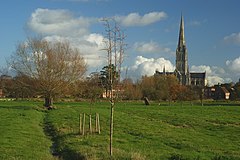
Britford is a village and civil parish beside the River Avon about 1.5 miles (2.4 km) south-east of Salisbury in Wiltshire, England. The village is just off the A338 Salisbury-Bournemouth road. The 2011 Census recorded a parish population of 592.
Downton is a village and civil parish on the River Avon in southern Wiltshire, England, about 6 miles (10 km) southeast of the city of Salisbury. The parish is on the county boundary with Hampshire and is close to the New Forest; it includes the villages of Wick and Charlton-All-Saints, and the small ancient settlement of Witherington. The Trafalgar Park estate erased the former settlement of Standlynch. The parish church, Trafalgar House, and two more houses are Grade I listed.
Manningford is a civil parish in Wiltshire, England. The parish includes the villages of Manningford Abbots, Manningford Bohune and Manningford Bruce, and the hamlet of Manningford Bohune Common, together known as the Manningfords.
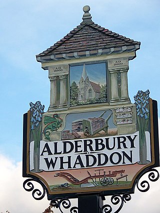
Alderbury is a village and civil parish in Wiltshire, England, in the south of the county around 3 miles (5 km) southeast of Salisbury.
Salisbury City Council is a parish-level council for Salisbury, England. It was established in April 2009 and is based in the city's historic Guildhall. Following the May 2021 election, no party has an overall majority.
Malmesbury is a town and civil parish in north Wiltshire, England, which lies approximately 14 miles (23 km) west of Swindon, 25 miles (40 km) northeast of Bristol, and 9 miles (14 km) north of Chippenham. The older part of the town is on a hilltop which is almost surrounded by the upper waters of the Bristol Avon and one of its tributaries.
Wilcot is a village and former civil parish, now in the parish of Wilcot, Huish and Oare, in Wiltshire, England, in the Vale of Pewsey about 6 miles (10 km) southwest of Marlborough and 1.5 mi (2.4 km) northwest of Pewsey. In 2011 the parish had a population of 558.
Laverstock is a village and civil parish on the north-east and east outskirts of Salisbury in the ceremonial county of Wiltshire, England. The parish is shaped like a figure 7 and incorporates Ford hamlet, the eastern half of the former manor of Milford, the area near the ancient settlement of Old Sarum, and part of the Hampton Park district on the edge of Salisbury.
Netherhampton is a village and civil parish in Wiltshire, England, immediately west of the city of Salisbury. The village is about 2 miles (3.2 km) from the city centre.
The College of the Valley Scholars of St Nicholas, sometimes called the Valley College and De Vaux College, was a seat of learning in Salisbury, England.
Harnham Gate is a historic gateway in the city of Salisbury in Wiltshire, England. Standing at the southern end of the cathedral close of Salisbury Cathedral, it is also known as the South Gate. It dates back to the fourteenth century and leads to a road connecting the suburb of Harnham on the southern side of the city, across the River Avon. The adjoining gatehouse was rebuilt in the late eighteenth or early nineteenth century. The gateway and gatehouse are now Grade I listed by Historic England.