Holy Ghost, New Mexico

Last updated

Holy Ghost
USA New Mexico location map.svg
Red pog.svg
Holy Ghost
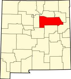
Location within the state of New Mexico
Usa edcp location map.svg
Red pog.svg
Holy Ghost
Holy Ghost (the United States)
Coordinates: 35°45′36″N105°41′33″W / 35.76000°N 105.69250°W / 35.76000; -105.69250
Country United States
State New Mexico
County San Miguel
Elevation
7,976 ft (2,431 m)
Time zone UTC-7 (Mountain (MST))
  Summer (DST) UTC-6 (MDT)
GNIS feature ID907043 [1]

Holy Ghost is an unincorporated community in San Miguel County, New Mexico, United States. [1]

The settlement is located within the Santa Fe National Forest, approximately 14 mi (23 km) northeast of Santa Fe.

The United States Forest Service translated the area's Spanish name, Espiritu Santo (Holy Spirit), and applied it to a campground, summer home area and creek located there. [2]

The Forest Service describes the Holy Ghost Campground as "situated in a beautiful steep canyon right along Holy Ghost Creek". [3]

Climate

Climate data for Hawley Lake, Arizona (1967-1988)
MonthJanFebMarAprMayJunJulAugSepOctNovDecYear
Record high °F (°C)67
(19)
65
(18)
74
(23)
76
(24)
85
(29)
90
(32)
90
(32)
89
(32)
86
(30)
79
(26)
77
(25)
69
(21)
90
(32)
Mean maximum °F (°C)56
(13)
56
(13)
60
(16)
68
(20)
75
(24)
85
(29)
86
(30)
83
(28)
79
(26)
72
(22)
65
(18)
58
(14)
88
(31)
Average high °F (°C)41.8
(5.4)
43.1
(6.2)
47.5
(8.6)
55.4
(13.0)
64.3
(17.9)
74.7
(23.7)
78.2
(25.7)
75.4
(24.1)
70.5
(21.4)
60.8
(16.0)
51.3
(10.7)
43.5
(6.4)
58.9
(14.9)
Daily mean °F (°C)26.2
(−3.2)
28.3
(−2.1)
32.8
(0.4)
39.7
(4.3)
47.3
(8.5)
55.8
(13.2)
59.8
(15.4)
58.8
(14.9)
53.0
(11.7)
44.1
(6.7)
34.6
(1.4)
27.6
(−2.4)
40.7
(4.8)
Average low °F (°C)10.7
(−11.8)
13.4
(−10.3)
18.2
(−7.7)
24.1
(−4.4)
29.9
(−1.2)
36.9
(2.7)
42.5
(5.8)
42.2
(5.7)
35.5
(1.9)
27.3
(−2.6)
18.5
(−7.5)
11.9
(−11.2)
24.6
(−4.1)
Mean minimum °F (°C)−8
(−22)
−5
(−21)
−1
(−18)
11
(−12)
21
(−6)
27
(−3)
34
(1)
35
(2)
25
(−4)
16
(−9)
3
(−16)
−6
(−21)
−15
(−26)
Record low °F (°C)−32
(−36)
−27
(−33)
−19
(−28)
−11
(−24)
9
(−13)
10
(−12)
24
(−4)
19
(−7)
12
(−11)
3
(−16)
−19
(−28)
−22
(−30)
−40
(−40)
Average precipitation inches (mm)1.19
(30)
1.50
(38)
1.57
(40)
1.58
(40)
1.73
(44)
1.81
(46)
4.17
(106)
3.68
(93)
2.30
(58)
1.76
(45)
0.94
(24)
1.05
(27)
23.28
(591)
Average snowfall inches (cm)13.3
(34)
16.6
(42)
17.4
(44)
8.6
(22)
2.3
(5.8)
0.0
(0.0)
0.0
(0.0)
0.0
(0.0)
0.2
(0.51)
2.4
(6.1)
7.5
(19)
10.7
(27)
79
(200.41)
Source: WRCC [4]

Related Research Articles

<span class="mw-page-title-main">Hebgen Lake</span> Lake in Gallatin County, Montana

Hebgen Lake is a reservoir created by the Hebgen Dam, located in Gallatin County in southwest Montana. It is well known for the 1959 Hebgen Lake earthquake which occurred nearby on August 17, 1959, forming Quake Lake, which is located immediately downstream.

<span class="mw-page-title-main">Sheridan Lake (South Dakota)</span> Reservoir in Pennington County, South Dakota

Sheridan Lake, a reservoir, is located on Spring Creek in Pennington County, South Dakota. Built over the site of Sheridan, the first county seat, it is owned and operated by the United States Forest Service and is one of the recreational areas of the Black Hills National Forest.

<span class="mw-page-title-main">Holy City, California</span> Unincorporated community in California, United States

Holy City is an unincorporated community in Santa Clara County, California. Once considered a Utopian community in the 1920s and 1930s, it is now considered a ghost town. The town is located in the Santa Cruz Mountains, off State Route 17 on Old Santa Cruz Highway. It is part of the Lexington Hills census designated place. Its ZIP code is 95026, and its area codes are 408 and 669.

<span class="mw-page-title-main">Kiowa National Grassland</span> Protected area in northeast New Mexico

Kiowa National Grassland is a National Grassland, located in northeastern New Mexico. The southwestern Great Plains grassland includes prairie and part of the Canadian River Canyon.

<span class="mw-page-title-main">Belmont Courthouse State Historic Park</span>

Belmont Courthouse is in the Toquima Range of Nye County. It is located in the ghost town of Belmont, 45 miles (72 km) northeast of Tonopah, Nevada.

<span class="mw-page-title-main">Cougar Reservoir</span> Reservoir in Lane County, Oregon

Cougar Reservoir is a reservoir on the South Fork McKenzie River in the U.S. state of Oregon. It is in Lane County, 46 miles (74 km) east of Eugene and about 3 miles (5 km) south of the community of Rainbow in the Willamette National Forest. In 1963 the United States Army Corps of Engineers built Cougar Dam on the river primarily to generate hydroelectricity and control flooding, and the reservoir formed behind the dam.

<span class="mw-page-title-main">Mono Hot Springs</span>

Mono Hot Springs is a summer resort and campground at a group of hot springs in Fresno County, central California. It is located within the Sierra National Forest, 70 miles (110 km) northeast of Fresno via California State Route 168.

<span class="mw-page-title-main">Raft River Mountains</span> Mountain range in Utah, United States

The Raft River Mountains are a mountain range in northern Box Elder County, Utah, United States. The mountains are located in the Raft River Division of the Minidoka Ranger District of the Sawtooth National Forest. The highest point is Bull Mountain, near the Dunn Benchmark, at 9,925 ft (3,025 m), and the ghost town of Yost is on the north-central slopes. Tributaries of the Raft River drain the northern slopes of the range to the Snake River then Columbia River and Pacific Ocean, while the southern slopes drain to the Great Salt Lake.

<span class="mw-page-title-main">Jemez River</span> River in New Mexico, United States

The Jemez River is a tributary of the Rio Grande in eastern Sandoval County, New Mexico, United States.

Big Piney Creek is a river located in Ozark National Forest in the state of Arkansas. It is a tributary of the Arkansas River and therefore part of the Mississippi River watershed. Managed by the United States Forest Service, it flows for 70.8 miles (113.9 km) through Pope, Johnson and Newton counties. The headwaters of the creek are in a rugged, remote area just east of Arkansas Route 21 south of the community of Fallsville and the mouth of the creek empties into Lake Dardanelle on the Arkansas River.

<span class="mw-page-title-main">South Fork McKenzie River</span> River in Oregon, United States

The South Fork McKenzie River is a tributary, about 31 miles (50 km) long, of the McKenzie River in the U.S. state of Oregon. It begins at about 4,500 feet (1,400 m) above sea level near Mink Lake in the Three Sisters Wilderness of the Cascade Range. Flowing northwest within Lane County, it meets the McKenzie River about 60 miles (97 km) from the larger river's confluence with the Willamette River.

<span class="mw-page-title-main">Tenmile Creek (Coos County, Oregon)</span> River in Oregon, United States

Tenmile Creek is the outlet for a chain of lakes ending at Tenmile Lake near Lakeside in Coos County in the U.S. state of Oregon. The creek flows generally west for about 3 miles (5 km) from the lake to the Pacific Ocean. The stream's name stems from its approximate distance from Winchester Bay, the earliest pioneer village along this part of the coast.

<span class="mw-page-title-main">Midway High Lakes Area</span>

Midway High Lakes Area, also known as High Lakes Area, is a United States Forest Service–designated area located in Washington’s Cascade Mountains. It lies on a high plateau on Mount Adams' northwestern flank. It is between the Goat Rocks on the north and Mount Hood to the south and contains Takhlakh Lake along with several other lakes. The area offers five scenic high elevation lakes all within a seven-mile (11 km) radius. It is administered by the Gifford Pinchot National Forest. While even the most visited areas at Mount Adams pale in comparison to nearby St. Helens or Rainier, it is by its own standards one of the most popular recreational areas around Mount Adams. Some of the lakes offers photogenic views of Mount Adams from across the lake.

<span class="mw-page-title-main">Beaver Creek (Crooked River tributary)</span> River in Oregon, United States

Beaver Creek is a tributary of the Crooked River in the U.S. state of Oregon. It is formed by the confluence of its two forks in southeastern Crook County, a sparsely populated part of Central Oregon. North Fork Beaver Creek flows south and then west around Laughlin Table. South Fork Beaver Creek drains the slopes of Snow Mountain and Funny Butte in southwestern Grant County before joining the North Fork.

<span class="mw-page-title-main">Lucerne, Washington</span> Unincorporated community in Washington, United States

Lucerne is an unincorporated community in Chelan County, Washington, United States. Lucerne is assigned the ZIP code 98816.

Ash Creek is a 35-mile (56 km) long stream located to the east of the Cascade Range in northeastern California, flowing through Lassen County and Modoc County. It drains a semi-arid watershed composed mainly of volcanic hills and agricultural valleys.

Wheeler Springs is an unincorporated community that grew around a set of sulphurated hot springs in Ventura County, California. It is located 6 miles north of the Ojai Valley, within Los Padres National Forest. It is named for Wheeler Blumberg, who founded the town in 1891, and the many natural hot springs.

The Matilija Wilderness is a 29,207-acre (11,820 ha) wilderness area in Ventura and Santa Barbara Counties, Southern California. It is managed by the U.S. Forest Service, being situated within the Ojai Ranger District of the Los Padres National Forest. It is located adjacent to the Dick Smith Wilderness to the northwest and the Sespe Wilderness to the northeast, although it is much smaller than either one. The Matilija Wilderness was established in 1992 in part to protect California condor habitat.

<span class="mw-page-title-main">Dango, Kentucky</span> Unincorporated community in Kentucky, United States

Dango is a ghost town located in southwestern Jackson County, Kentucky, United States. The town was located at the confluence of Racoon Creek and Horse Lick Creek, which flows into the Rockcastle River. It is located southwest of McKee by 8 miles, and 2.7 miles southeast of another ghost town, Loam. Near the confluence of the two creeks is the historical Carpenter School, which may be named after Carpenter Ridge, of which it is two miles south of. Heavy settlement and farming occurred in the area around Horse Lick Creek, where Dango was, until the early 1900s. The area where Dango was is currently occupied by the Daniel Boone National Forest, known as the Horse Lick Creek Biopreserve, with the majority of ownership being private.

References

  1. 1 2 "Holy Ghost". Geographic Names Information System . United States Geological Survey, United States Department of the Interior.
  2. "Domestic Geographic Name Proposal". U.S. Geological Survey. January 13, 1965.
  3. "Holy Ghost Campground". U.S. Forest Service. Retrieved April 26, 2016.
  4. "Cowles, NM(292139)". Western Regional Climate Center. December 2012. Retrieved December 2, 2012.