Bernal, New Mexico

Last updated

Bernal, New Mexico
USA New Mexico location map.svg
Red pog.svg
Bernal, New Mexico
Coordinates: 35°23′34″N105°19′03″W / 35.39278°N 105.31750°W / 35.39278; -105.31750
Country United States
State New Mexico
County San Miguel
Elevation
6,152 ft (1,875 m)
Time zone UTC-7 (Mountain (MST))
  Summer (DST) UTC-6 (MDT)
Area code 505
GNIS feature ID903757 [1]

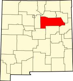
Bernal is an unincorporated community in San Miguel County, New Mexico, United States. [1] [2]

Notes

  1. 1 2 "Bernal, New Mexico". Geographic Names Information System . United States Geological Survey, United States Department of the Interior.
  2. Bernal Topo Map in San Miguel County NM


Related Research Articles

<span class="mw-page-title-main">San Miguel County, New Mexico</span> County in New Mexico, United States

San Miguel County is a county in the U.S. state of New Mexico. As of the 2020 census, the population was 27,201. Its county seat is Las Vegas.

<span class="mw-page-title-main">Pecos, New Mexico</span> Village in New Mexico, United States

Pecos is a village in San Miguel County, New Mexico, United States. The population was 1,392 at the 2010 census, shrinking slower than other parts of San Miguel County, partly because Pecos is within commuting distance of Santa Fe. The village is built along the Pecos River, which flows from the north out of the Santa Fe National Forest. Notable locations nearby include Pecos National Historical Park, Glorieta Pass, Pecos Benedictine Monastery, and Lisboa Springs Trout Hatchery. It is also an entry point for hunting, fishing, hiking and camping in the Pecos Wilderness. The closest metropolitan area is the Santa Fe metropolitan area, approximately 26 miles (42 km) to the west.

Bernal is a Spanish given name and surname, equivalent to the English name Bernard.

Villanueva is an unincorporated community and census-designated place in San Miguel County, New Mexico, United States. Known as La Cuesta until 1890, it is located along the Pecos River and New Mexico State Road 3. Villanueva has the ZIP code 87583. The 87583 ZIP Code Tabulation Area had a population of 234 in the 2010 United States census, compared to 267 in 2000. A total of 211 residents of Villanueva in 2010 identified themselves as Hispanic.

<span class="mw-page-title-main">Miguel Bernal Jiménez</span> Mexican musician (1910–1956)

Miguel Bernal Jiménez was a Mexican composer, organist, pedagogist and musicologist.

<span class="mw-page-title-main">Trinidad Romero</span> American politician

Trinidad Romero was an American politician and rancher who was the Delegate to United States Congress from the Territory of New Mexico.

<span class="mw-page-title-main">Santa Teresa Hills</span>

The Santa Teresa Hills are a range of mountains in Santa Clara County, California, located primarily in the city of San Jose. They separate the San Jose neighborhoods of Almaden Valley to the west and Santa Teresa to the east.

<span class="mw-page-title-main">National Register of Historic Places listings in San Miguel County, New Mexico</span>

This is a list of the National Register of Historic Places listings in San Miguel County, New Mexico.

Rancho Santa Teresa was a 9,647-acre (39.04 km2) Mexican land grant in present-day Santa Clara County, California given in 1834 by Governor José Figueroa to José Joaquín Bernal. The grant extended west from Coyote Creek to the Santa Teresa Hills, and included present-day Santa Teresa.

<span class="mw-page-title-main">Rancho Valle de San José</span>

Rancho Valle de San José was a 48,436-acre (196.01 km2) Mexican land grant in present-day Alameda County, California. It was made up of the former pasture land belonging to Mission San José.

<span class="mw-page-title-main">Rancho Cañada Larga o Verde</span> Mexican land grant in Ventura County, California

Rancho Cañada Larga o Verde was a 6,659-acre (26.95 km2) Mexican land grant in present-day Ventura County, California given in 1841 by Governor Juan B. Alvarado to Joaquina Alvarado. The grant extended along Sulphur Canyon Creek, east of the Ventura River, between Ventura and Ojai. To the west, across the Ventura River was Rancho Cañada de San Miguelito; to the north Rancho Ojai; and to the south and east Rancho Ex-Mission San Buenaventura.

<span class="mw-page-title-main">San Miguel del Vado Land Grant</span>

The San Miguel del Vado Land Grant is one of the Spanish land grants in New Mexico. On November 24, 1794, 53 men submitted a petition for land and were granted temporary possession on November 24, 1794, pending satisfaction of prescribed criteria. A second grant was obtained by 58 men and their respective families on March 12, 1803. Two days later, the procedure was repeated at San José del Vado, 6 kilometres (3.7 mi) north of San Miguel del Vado, distributing farm land to an additional 47 heads of household, including two women.

<span class="mw-page-title-main">Costilla, New Mexico</span> Census-designated place in New Mexico, United States

Costilla is a census-designated place in Taos County, New Mexico, United States. Its population was 205 as of the 2010 census. Costilla has a post office with ZIP code 87524. State roads 196 and 522 intersect in the community.

San Jose is a census-designated place in San Miguel County, New Mexico, United States. Its population was 137 as of the 2010 census. San Jose has a post office, with ZIP code 87565. Exit 319 of Interstate 25 serves the community.

Garita, also known as Variadero, is an unincorporated community located in San Miguel County, New Mexico, United States. The community is located on New Mexico State Road 104 where it crosses the Conchas River. It was founded in 1872 by Jesús Angel, a settler from Bernal.

Sena is an unincorporated community and census-designated place in San Miguel County, New Mexico, United States. It is located along the Pecos River and New Mexico State Highway 3.

<span class="mw-page-title-main">San Miguel, Arizona</span> CDP in Pima County, Arizona

San Miguel is a census-designated place in Pima County, in the U.S. state of Arizona. The population was 207 as of the 2020 census. San Miguel is located near the border with Mexico on the Tohono O'odham Nation reservation.

<span class="mw-page-title-main">El Porvenir, New Mexico</span> Unincorporated community in New Mexico, United States

El Porvenir is an unincorporated community in San Miguel County, New Mexico, United States.

<i>Hernán</i> (TV series) Spanish-Mexican historical drama TV series

Hernán is a Spanish, Nahuatl, and Maya language historical drama streaming television series co-produced by Televisión Azteca, Dopamine, and Onza Entertainment that became available for streaming worldwide on Amazon Prime Video on 21 November 2019, except in the United States, and it will subsequently premiere on 22 November 2019 on History in Latin America, and later on TV Azteca on 24 November 2019 in Mexico. The first season consists of 8 episodes, and a second season has been confirmed, which will begin filming in January 2020. The series planned its premiere as part of the 500th anniversary of the Fall of Tenochtitlan and revolves around Hernán Cortés from his arrival at the Mexican coast until the defeat of the Mexicas.