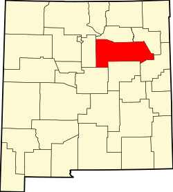
El Porvenir, New Mexico | |
---|---|
Coordinates: 35°41′48″N105°22′58″W / 35.69667°N 105.38278°W Coordinates: 35°41′48″N105°22′58″W / 35.69667°N 105.38278°W | |
Country | United States |
State | New Mexico |
County | San Miguel |
Elevation | 7,290 ft (2,220 m) |
Time zone | UTC-7 (Mountain (MST)) |
• Summer (DST) | UTC-6 (MDT) |
Area code(s) | 505 |
GNIS feature ID | 906073 [1] |
El Porvenir is an unincorporated community in San Miguel County, New Mexico, United States. [1] [2]
San Miguel County is a county in the U.S. state of New Mexico. As of the 2010 census, the population was 29,393. Its county seat is Las Vegas.
San Elizario is a city in El Paso County, Texas, United States. Its population was 13,603 at the 2010 census. It is part of the El Paso metropolitan statistical area. It lies on the Rio Grande, which forms the border between the United States and Mexico. The city of Socorro adjoins it on the west and the town of Clint lies to the north.
Córdoba, officially known as Heroica Córdoba, is a city and the seat of the municipality of the same name in the Mexican state of Veracruz. It was founded in 1618.
San Miguel de Allende is the principal city in the municipality of San Miguel de Allende, located in the far eastern part of Guanajuato, Mexico. A part of the Bajío region, the city lies 274 km (170 mi) from Mexico City, 86 km (53 mi) from Querétaro, and 97 km (60 mi) from the state capital of Guanajuato. The city's name derives from two persons: 16th-century friar Juan de San Miguel, and a martyr of Mexican Independence, Ignacio Allende, who was born in a house facing the city's central plaza. San Miguel de Allende was also a critical epicenter during the historic Chichimeca War (1540–1590) where the Chichimeca Confederation defeated the Spanish Empire in the initial colonization war. Today, an old section of the town is part of a proclaimed World Heritage Site, attracting thousands of tourists and new residents from abroad every year.
El Porvenir or Porvenir may refer to:
El Porvenir is a municipio (municipality) and township in the Mexican state of Chiapas.
Villanueva is an unincorporated community and census-designated place in San Miguel County, New Mexico, United States. Known as La Cuesta until 1890, it is located along the Pecos River and New Mexico State Road 3. Villanueva has the ZIP code 87583. The 87583 ZIP Code Tabulation Area had a population of 234 in the 2010 United States census, compared to 267 in 2000. A total of 211 residents of Villanueva in 2010 identified themselves as Hispanic.
The Camino Real de Tierra Adentro was an historic 2,560-kilometre-long (1,590 mi) trade route between Mexico City and San Juan Pueblo, New Mexico, USA, from 1598 to 1882. It was the northernmost of the four major "royal roads" that linked Mexico City to its major tributaries during and after the Spanish colonial era.
Hermit Peak is a mountain in San Miguel County, in northern New Mexico, United States.
The Albuquerque–Santa Fe–Las Vegas combined statistical area is made up of eight counties in north central New Mexico. The combined statistical area consists of the Albuquerque and Santa Fe metropolitan statistical areas, and the Las Vegas, Los Alamos, and Española micropolitan statistical areas. The 2013 delineations included the Grants micropolitan statistical area, but it was removed in the 2018 revisions. As of the 2010 census, the CSA had a population of 1,146,049. The population of the CSA is 1,178,664 as of the July 1, 2018 Census Bureau estimate. Roughly 56% of New Mexico's residents live in this area. Prior to the 2013 redefintions, the CSA consisted only of the Santa Fe metropolitan statistical area and the Española micropolitan statistical area. The total land area of the Albuquerque–Santa Fe–Las Vegas combined statistical area in the 2013 definition is 26,421 sq. mi.
The Fort Hancock–El Porvenir International Bridge is an international bridge which crosses the Rio Grande connecting the United States–Mexico border cities of Fort Hancock, Texas and El Porvenir, Chihuahua. The two-lane international bridge was constructed in 1936 and is 1,855 feet (565 m) long. The Fort Hancock Port of Entry is located on the Texas side of the bridge and connects to Farm to Market Road 1088.
The Mis Romances Tour was a concert tour performed by Luis Miguel during the year 2002 to promote his 2001 album Mis Romances. The tour consisted in 63 concerts and ran through US, Mexico, Argentina, Spain, Chile, Uruguay, Peru, Dominican Republic and Puerto Rico. In February he performed at the Universal Amphitheatre in Los Angeles, California for six consecutive sold-out nights drawing more than 32,000 spectators, beating his previous record of five consecutive concerts in this venue, he played also two more concerts in September. Miguel performed at Mexico's Aztec Stadium for first time in his career in front of 80,000 spectators, and also gave twelve nights at National Auditorium in Mexico City.
San Miguel el Alto is a town and municipality, in Jalisco in central-western Mexico. The municipality covers an area of 580 km².
Rancho El Cajón was a 48,800-acre (197 km2) Mexican land grant in present day San Diego County, California given in 1845 by Governor Pio Pico to María Antonia Estudillo de Pedrorena. The name means "the box" in Spanish, and refers to the valley between hills. The grant encompassed present day El Cajon, Bostonia, Santee, Lakeside, Flinn Springs, and the eastern part of La Mesa. The grant contained the 28-acre (0.11 km2) Rancho Cañada de los Coches grant.
El Cerrito is a village in San Miguel County, New Mexico, United States. The village is located in the upper Pecos River valley and was founded in 1824 by settlers from Villanueva, 5 kilometres (3.1 mi) upstream. The majority of the population is Hispanic.
Cuitzeo is a municipality located in the north of the Mexican state of Michoacán. The municipal seat is the town of Cuitzeo del Porvenir It is located in a relatively flat depression around Lake Cuitzeo, a large, very shallow lake, which is in danger of disappearing. The town was officially founded in 1550, with the founding of a large Augustinian monastery, which still stands. Today, the town is the seat of a rural municipality, providing local government to surrounding communities.
San Telmo is a village in Baja California, Mexico. It is a small village situated along the Pacific border of Mexico's Baja California Peninsula. It is registered within the Licenciado Gustavo Días Ordaz municipality, which is a part of the massive Ensenada municipality of the State of Baja California. It is also a part of a region in Baja California called Heroes de Chapultepec —2,142 kilometres (1,331 mi) northwest of Mexico City, the country's capital city. San Telmo is also known as El Bramadero.
The Porvenir massacre was an incident on January 28, 1918 outside the village of Porvenir in Presidio County, Texas, in which Texas Rangers and local ranchers killed 15 unarmed Mexican American boys and men. The Texas Rangers Company B was sent to the area to stop banditry after the Brite Ranch raid. Despite having no evidence that the Porvenir villagers were involved in recent thefts or the killings of ranchers, the Rangers separated fifteen men and boys from the rest of the village and shot them on a nearby hill.
La Matanza and the Hora de Sangre was a period of anti-Mexican violence in Texas, including lynchings and massacres, between 1910 and 1920 in the midst of tensions between the United States and Mexico during the Mexican Revolution. This violence was committed by Anglo-Texan vigilantes, and law enforcement, such as the Texas Rangers, during operations against bandit raids known as the Bandit Wars. The violence and denial of civil liberties during this period was justified by racism. Ranger violence reached its peak from 1915 to 1919, in response to increasing conflict, initially because of the Plan de San Diego, by Mexican and Tejano insurgents to take Texas. This period was referred to as the Hora de Sangre by Mexicans in South Texas, many of whom fled to Mexico to escape the violence. At least 300 Mexican Americans were killed in Texas during the 1910s, with total estimates of ranging from hundreds to thousands killed. At least 100 Mexican Americans were lynched in the 1910s, many in Texas. Many murders were concealed and went unreported, with some in South Texas, suspected by Rangers of supporting rebels, being placed on blacklists and often "disappearing".
A Mexican American is a resident of the United States who is of Mexican descent. Mexican American-related topics include the following: