Sena, New Mexico

Last updated

Sena, New Mexico
USA New Mexico location map.svg
Red pog.svg
Sena
Location within the state of New Mexico
Coordinates: 35°17′54″N105°21′34″W / 35.29833°N 105.35944°W / 35.29833; -105.35944 [1]
Country United States
State New Mexico
County San Miguel
Area
[2]
  Total2.13 sq mi (5.51 km2)
  Land2.13 sq mi (5.51 km2)
  Water0.00 sq mi (0.00 km2)
Elevation
[1]
5,876 ft (1,791 m)
Population
 (2020) [3]
  Total155
  Density72.91/sq mi (28.15/km2)
Time zone UTC-7 (MST)
  Summer (DST) UTC-6 (MDT)
Area code 505
FIPS code 35-71790 [1]
GNIS ID 910937 [1]

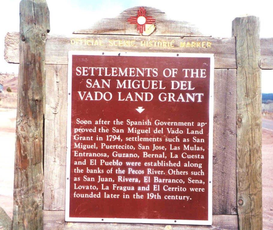
Sena is an unincorporated community and census-designated place in San Miguel County, New Mexico, United States. [1] It is located along the Pecos River and New Mexico State Highway 3.

Contents

Demographics

Historical population
CensusPop.Note
2020 155
U.S. Decennial Census [4] [3]

History

Sena was founded in the 19th century. [5]

Economy

Sena has no commercial enterprises of its own. The nearest store and Post Office is 3.2 miles (5.1 km) southeast, in the community of Villanueva.[ citation needed ]

Education

It is in the West Las Vegas Schools school district. [6] West Las Vegas High School is the area high school.

See also

Related Research Articles

<span class="mw-page-title-main">Tierra Amarilla, New Mexico</span> Census-designated place in New Mexico, United States

Tierra Amarilla is a census-designated place in and the county seat of Rio Arriba County, New Mexico, United States.

<span class="mw-page-title-main">San Miguel County, New Mexico</span> County in New Mexico, United States

San Miguel County is a county in the U.S. state of New Mexico. As of the 2020 census, the population was 27,201. Its county seat is Las Vegas.

<span class="mw-page-title-main">Mora County, New Mexico</span> County in New Mexico, United States

Mora County is a county in the U.S. state of New Mexico. As of the 2020 census, the population was 4,189. Its county seat is the census-designated place (CDP) Mora. The county has another CDP, Watrous, a village, Wagon Mound, and 12 smaller unincorporated settlements. Mora became a formal county in the US, in what was then the New Mexico Territory, on February 1, 1860. Ecclesiastically, the county is within the Roman Catholic Archdiocese of Santa Fe. County population peaked at approximately 14,000 circa 1920, declining to about 4,000 to 5,000 since the 1970s; the 2018 estimate was 4,506.

<span class="mw-page-title-main">Vado, New Mexico</span> Place and community in the United States

Vado is an unincorporated community and census-designated place (CDP) in Doña Ana County, New Mexico, United States. The population was 3,194 at the 2010 census. The ZIP code for Vado is 88072, its area code is 575, and it is part of the Las Cruces Metropolitan Statistical Area.

<span class="mw-page-title-main">Las Vegas, New Mexico</span> City in New Mexico, United States

Las Vegas is a city in and the county seat of San Miguel County, New Mexico, United States. Once two separate municipalities, both were named Las Vegas—West Las Vegas and East Las Vegas ; they are separated by the Gallinas River and retain distinct characters and separate, rival school districts.

Villanueva is an unincorporated community and census-designated place in San Miguel County, New Mexico, United States. Known as La Cuesta until 1890, it is located along the Pecos River and New Mexico State Road 3. Villanueva has the ZIP code 87583. The 87583 ZIP Code Tabulation Area had a population of 234 in the 2010 United States census, compared to 267 in 2000. A total of 211 residents of Villanueva in 2010 identified themselves as Hispanic.

<span class="mw-page-title-main">Ribera, New Mexico</span> CDP in New Mexico, United States

Ribera is an unincorporated community and census-designated place in San Miguel County, New Mexico. Located in the northern part of the state, it is at the foot of Rowe Mesa and along the Pecos River, 50 miles (80 km) southeast of Santa Fe.

Las Vegas City Schools is a school district based in Las Vegas, New Mexico, United States.

West Las Vegas Public Schools is a school district based in Las Vegas, New Mexico, United States.

<span class="mw-page-title-main">Rowe, New Mexico</span> Census-designated place in San Miguel County, New Mexico, United States

Rowe is a census-designated place (CDP) in San Miguel County, New Mexico, United States.

<span class="mw-page-title-main">Organ, New Mexico</span> Census-designated place in New Mexico, United States

Organ is an unincorporated community and census-designated place in Doña Ana County, New Mexico, United States. As of the 2010 census, its population was 323.

<span class="mw-page-title-main">San Miguel del Vado, New Mexico</span> Unincorporated community in New Mexico, United States

San Miguel del Vado is an unincorporated community in San Miguel County, New Mexico, United States.

Hispanic and Latino Nevadans are residents of the state of Nevada who are of Hispanic or Latino ancestry. As of the 2020 U.S. Census, Hispanics and Latinos of any race were 28.3% of the state's population.

<span class="mw-page-title-main">Costilla, New Mexico</span> Census-designated place in New Mexico, United States

Costilla is a census-designated place in Taos County, New Mexico, United States. Its population was 205 as of the 2010 census. Costilla has a post office with ZIP code 87524. State roads 196 and 522 intersect in the community.

San Jose is a census-designated place in San Miguel County, New Mexico, United States. Its population was 137 as of the 2010 census. San Jose has a post office, with ZIP code 87565. Exit 319 of Interstate 25 serves the community.

Anton Chico, or Anton Chico Abajo or Anton Chico de Abajo, is a census-designated place in Guadalupe County, New Mexico, United States. Its population was 188 as of the 2010 census, of which 167 were Hispanic in origin. Anton Chico has a post office with ZIP code 87711. New Mexico State Road 386 passes through the community. Anton Chico is listed in the National Register of Historic Places.

East Pecos is an unincorporated community and census-designated place in San Miguel County, New Mexico, United States. Its population was 757 as of the 2010 census.

North San Ysidro is an unincorporated community and census-designated place in San Miguel County, New Mexico, United States. Its population was 159 as of the 2010 census.

Pueblo is an unincorporated community and census-designated place in San Miguel County, New Mexico, United States. Its population was 125 as of the 2010 census. New Mexico State Road 3 passes through the community.

Tecolote is an unincorporated community and census-designated place in San Miguel County, New Mexico, United States. Its population was 298 as of the 2010 census. The community is located along Interstate 25 at Exit 335.

References

  1. 1 2 3 4 5 Geographic Names Information System (GNIS) details for Sena, New Mexico; United States Geological Survey (USGS); November 13, 1980.
  2. "ArcGIS REST Services Directory". United States Census Bureau. Retrieved October 12, 2022.
  3. 1 2 "Census Population API". United States Census Bureau. Retrieved October 12, 2022.
  4. "Census of Population and Housing". Census.gov. Retrieved June 4, 2016.
  5. Settlements of the San Miguel Del Vado Land Grant; Official Scenic Historic Marker.
  6. "2020 CENSUS - SCHOOL DISTRICT REFERENCE MAP: San Miguel County, NM" (PDF). U.S. Census Bureau . Retrieved July 12, 2022.