Soham, New Mexico

Last updated

Soham, New Mexico
USA New Mexico location map.svg
Red pog.svg
Soham
Coordinates: 35°25′00″N105°30′22″W / 35.41667°N 105.50611°W / 35.41667; -105.50611
Country United States
State New Mexico
County San Miguel
Area
[1]
  Total1.55 sq mi (4.01 km2)
  Land1.55 sq mi (4.01 km2)
  Water0.00 sq mi (0.00 km2)
Elevation
[2]
6,132 ft (1,869 m)
Population
 (2020) [3]
  Total147
  Density95.02/sq mi (36.69/km2)
Time zone UTC-7 (Mountain (MST))
  Summer (DST) UTC-6 (MDT)
Area code 505
GNIS feature ID2584219 [2]

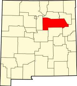
Soham is an unincorporated community and census-designated place in San Miguel County, New Mexico, United States. Its population was 210 as of the 2010 census. [4] The community is located near Exit 319 on Interstate 25.

Contents

Geography

According to the U.S. Census Bureau, the community has an area of 1.547 square miles (4.01 km2), all land. [4]

Demographics

Historical population
CensusPop.Note
2020 147
U.S. Decennial Census [5] [3]

Education

It is within Pecos Independent Schools. [6]

Related Research Articles

<span class="mw-page-title-main">San Miguel County, New Mexico</span> County in New Mexico, United States

San Miguel County is a county in the U.S. state of New Mexico. As of the 2020 census, the population was 27,201. Its county seat is Las Vegas.

Villanueva is an unincorporated community and census-designated place in San Miguel County, New Mexico, United States. Known as La Cuesta until 1890, it is located along the Pecos River and New Mexico State Road 3. Villanueva has the ZIP code 87583. The 87583 ZIP Code Tabulation Area had a population of 234 in the 2010 United States census, compared to 267 in 2000. A total of 211 residents of Villanueva in 2010 identified themselves as Hispanic.

<span class="mw-page-title-main">Ribera, New Mexico</span> CDP in New Mexico, United States

Ribera is an unincorporated community and census-designated place in San Miguel County, New Mexico. Located in the northern part of the state, it is at the foot of Rowe Mesa and along the Pecos River, 50 miles (80 km) southeast of Santa Fe.

<span class="mw-page-title-main">Rowe, New Mexico</span> Census-designated place in San Miguel County, New Mexico, United States

Rowe is a census-designated place (CDP) in San Miguel County, New Mexico, United States.

<span class="mw-page-title-main">Costilla, New Mexico</span> Census-designated place in New Mexico, United States

Costilla is a census-designated place in Taos County, New Mexico, United States. Its population was 205 as of the 2010 census. Costilla has a post office with ZIP code 87524. State roads 196 and 522 intersect in the community.

San Jose is a census-designated place in San Miguel County, New Mexico, United States. Its population was 137 as of the 2010 census. San Jose has a post office, with ZIP code 87565. Exit 319 of Interstate 25 serves the community.

San Miguel is a census-designated place in Doña Ana County, New Mexico, United States. Its population was 1,153 as of the 2010 census. San Miguel has a post office with ZIP code 88058. The community is located at the junction of state routes 28 and 192.

San Pablo is a census-designated place in Doña Ana County, New Mexico, United States. Its population was 806 as of the 2010 census. The community is located south of Las Cruces along New Mexico State Road 28.

Sena is an unincorporated community and census-designated place in San Miguel County, New Mexico, United States. It is located along the Pecos River and New Mexico State Highway 3.

Cedar Hill is an unincorporated community and census-designated place in San Juan County, New Mexico, United States. Its population was 847 as of the 2010 census. The community is located on U.S. Route 550, near the Colorado border. Cedar Hill was originally known as Cox's Crossing. The name was chosen during a Literacy Society meeting by picking names out of a hat. A post office operated from 1892 to 1966.

North Light Plant is an unincorporated community and census-designated place in San Juan County, New Mexico, United States. Its population was 414 as of the 2010 census. New Mexico State Road 574 passes through the community.

East Pecos is an unincorporated community and census-designated place in San Miguel County, New Mexico, United States. Its population was 757 as of the 2010 census.

North San Ysidro is an unincorporated community and census-designated place in San Miguel County, New Mexico, United States. Its population was 159 as of the 2010 census.

Pueblo is an unincorporated community and census-designated place in San Miguel County, New Mexico, United States. Its population was 125 as of the 2010 census. New Mexico State Road 3 passes through the community.

Tecolote is an unincorporated community and census-designated place in San Miguel County, New Mexico, United States. Its population was 298 as of the 2010 census. The community is located along Interstate 25 at Exit 335.

Tecolotito is an unincorporated community and census-designated place in San Miguel County, New Mexico, United States. The word "Tecolotito" has its origin in the Nahuatl language. Adopted into Spanish it means "small owl." The population of the community was 232 as of the 2010 census, of which 213 people were of Hispanic origin.

San Pedro is an unincorporated community and census-designated place in Santa Fe County, New Mexico, United States. Its population was 184 as of the 2010 census. New Mexico State Road 344 passes through the community.

San Luis is an unincorporated community and census-designated place in Sandoval County, New Mexico, United States. Its population was 59 as of the 2010 census. New Mexico State Road 279 passes through the community.

Chamita is a census-designated place in Rio Arriba County, New Mexico, United States. Its population was 870 as of the 2010 census. New Mexico State Road 74 passes through the community. During its earlier years, the community was known as San Pedro De Chamita and served as the first county seat for Rio Arriba county.

San Francisco el Duende, more commonly known as El Duende is an unincorporated community and census-designated place in Rio Arriba County, New Mexico, United States. Its population was 707 as of the 2010 census. The community is located at the junction of U.S. Routes 84/285 and New Mexico State Road 74.

References

  1. "ArcGIS REST Services Directory". United States Census Bureau. Retrieved October 12, 2022.
  2. 1 2 U.S. Geological Survey Geographic Names Information System: Soham, New Mexico
  3. 1 2 "Census Population API". United States Census Bureau. Retrieved October 12, 2022.
  4. 1 2 "2010 Census Gazetteer Files - Places: New Mexico". U.S. Census Bureau . Retrieved December 31, 2016.
  5. "Census of Population and Housing". Census.gov. Retrieved June 4, 2016.
  6. "2020 CENSUS - SCHOOL DISTRICT REFERENCE MAP: San Miguel County, NM" (PDF). U.S. Census Bureau . Retrieved July 14, 2022.