Hood, Pennsylvania

Last updated

Hood, Pennsylvania
Populated place
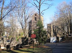
Hood, PA - Heath mills.jpg
Ruins of Robert Heath Mills
USA Pennsylvania location map.svg
Red pog.svg
Hood, Pennsylvania
Location of Hood in Pennsylvania
Coordinates: 40°21′39″N74°57′47″W / 40.36083°N 74.96306°W / 40.36083; -74.96306
Country United States
State Pennsylvania
County Bucks
Borough New Hope
Elevation
[1]
108 ft (33 m)
Time zone UTC-5 (Eastern (EST))
  Summer (DST) UTC-4 (EDT)
Area code 215
FIPS code 42-35558
GNIS feature ID 1203833

Hood is a populated place that is located in New Hope, a borough in Bucks County, Pennsylvania, United States. [2]

Contents

History

The site features ruins of the Robert Heath Mills, a grist mill built in the early 1700s. [3]

The original name of this community was Springdale. [ citation needed ]

Geography

Hood has an estimated elevation of 108 feet (33 m) above sea level and is located at the intersection of Mechanic Street and Sugan Road. Located near the settlement are Aquetong Creek and New Hope and Ivyland Railroad. [4]

See also

Springdale Historic District (New Hope, Pennsylvania)

Related Research Articles

<span class="mw-page-title-main">Bucks County, Pennsylvania</span> County in Pennsylvania, United States

Bucks County is a county in the Commonwealth of Pennsylvania. As of the 2020 census, the population was 646,538, making it the fourth-most populous county in Pennsylvania. Its county seat is Doylestown. The county is named after the English county of Buckinghamshire.

<span class="mw-page-title-main">New Hope, Pennsylvania</span> Borough in Pennsylvania, United States

New Hope is a borough in Bucks County, Pennsylvania, United States. The population was 2,612 at the 2020 census. New Hope is located approximately 30 mi (48 km) north of Philadelphia, and lies on the west bank of the Delaware River at its confluence with Aquetong Creek. New Hope and the surrounding Solebury Township and Upper Makefield Township are part of the Philadelphia metropolitan area. The two-lane New Hope–Lambertville Bridge carries automobile and foot traffic across the Delaware to Lambertville, New Jersey, on the east bank.

<span class="mw-page-title-main">Solebury Township, Bucks County, Pennsylvania</span> Township in Pennsylvania, United States

Solebury Township is a township in Bucks County, Pennsylvania, United States. The population was 8,709 at the 2020 census.

<span class="mw-page-title-main">Pennsylvania Route 32</span> State highway in Bucks County, Pennsylvania, United States

Pennsylvania Route 32 is a scenic two-lane highway that runs along the west side of the Delaware River in Bucks County, Pennsylvania. Signed north-south, it runs from U.S. Route 1 in Falls Township outside of Morrisville northwest to PA 611 in the village of Kintnersville in Nockamixon Township. PA 32 passes through Washington Crossing Historic Park, a Revolutionary War-themed historical park on the site of George Washington's crossing on the night of December 25–26, 1776. It also passes through the boroughs of Morrisville, Yardley, and New Hope.

<span class="mw-page-title-main">Ridley Creek State Park</span> State park in Pennsylvania, U.S.

Ridley Creek State Park is a 2,606-acre (1,055 ha) Pennsylvania state park in Edgmont, Middletown, and Upper Providence Townships, Delaware County, Pennsylvania in the United States. The park, about 5 miles (8 km) north of the county seat of Media, offers many recreational activities, such as hiking, biking, fishing, and picnicking. Ridley Creek passes through the park. Highlights include a 5-mile (8 km) paved multi-use trail, a formal garden designed by the Olmsted Brothers, and Colonial Pennsylvania Plantation, which recreates daily life on a pre-Revolutionary farm. The park is adjacent to the John J. Tyler Arboretum. Ridley Creek State Park is just over 16 miles (26 km) from downtown, Philadelphia between Pennsylvania Route 352 and Pennsylvania Route 252 on Gradyville Road.

<span class="mw-page-title-main">Pennsylvania Route 663</span> State highway in Pennsylvania, US

Pennsylvania Route 663 (PA 663) is a 22.13-mile-long (35.61 km) state highway in Montgomery and Bucks counties in southeast Pennsylvania. Its southern terminus is at PA 100 in the borough of Pottstown and its northern terminus is at PA 309 and PA 313 in the borough of Quakertown, where the road continues eastward as PA 313. Along the way, PA 663 also passes through the borough of Pennsburg. It is called John Fries Highway between Pennsburg and Quakertown. It has an interchange with Interstate 476 at exit 44 west of Quakertown. The route was assigned in 1930, and it has had several realignments since its commissioning, including two major ones.

<span class="mw-page-title-main">Pennsylvania Route 263</span> North–south state highway located in southeast Pennsylvania

Pennsylvania Route 263 (PA 263) is a north–south state highway located in southeast Pennsylvania. The southern terminus of the route is at PA 611 in Willow Grove, Montgomery County. The northern terminus is at the Centre Bridge–Stockton Bridge over the Delaware River in Centre Bridge, Bucks County, where the road continues into Stockton, New Jersey, as Bridge Street to an intersection with Route 29. PA 263 follows the routing of Old York Road, a historic road that connected Philadelphia to New York City, and carries the name York Road from the southern terminus to Lahaska and Upper York Road north of there. From Willow Grove to Buckingham, PA 263 runs mostly through suburban areas as a four-lane road, passing through Hatboro, Warminster, and Jamison. The route forms a concurrency with U.S. Route 202 (US 202) in Buckingham and narrows to a two-lane road, splitting with that route in Lahaska. From here, the route continues through rural areas to Centre Bridge.

<span class="mw-page-title-main">Conodoguinet Creek</span>

Conodoguinet Creek is a 104-mile-long (167 km) tributary of the Susquehanna River in South central Pennsylvania in the United States. The name is Native American, and means "A Long Way with Many Bends".

<span class="mw-page-title-main">Point Pleasant, Pennsylvania</span> Unincorporated community in the U.S. state of Pennsylvania

Point Pleasant is an unincorporated community in Tinicum and Plumstead Townships of Bucks County, Pennsylvania, United States. It lies on both sides of Tohickon Creek by the creek's confluence with the Delaware River; the creek is the dividing line between the townships. The ZIP code for the post office in Point Pleasant is 18950.

<span class="mw-page-title-main">Pennsylvania Route 232</span> State highway in Pennsylvania, US

Pennsylvania Route 232 (PA 232) is a 25.2-mile-long (40.6 km) state highway located in southeastern Pennsylvania. The southern terminus of the route is at U.S. Route 1 (US 1)/US 13 at the Oxford Circle in Philadelphia. The northern terminus is at PA 32 in the borough of New Hope, Bucks County, on the banks of the Delaware River. The route passes through the urban areas of Northeast Philadelphia as Oxford Avenue, serving the Lawncrest, Burholme, and Fox Chase neighborhoods. Upon entering Montgomery County, PA 232 becomes Huntingdon Pike and through suburban areas, serving the communities of Rockledge, Huntingdon Valley, and Bryn Athyn. The route passes through more suburban development in Bucks County as Second Street Pike, running through Southampton and Richboro. In Wrightstown Township, PA 232 enters rural areas and becomes Windy Bush Road as it heads north to New Hope.

Solebury is an unincorporated community in Solebury Township in Bucks County, Pennsylvania, United States. Solebury is located at the intersection of Pennsylvania Route 263, Sugan Road, and Phillips Mill Road.

<span class="mw-page-title-main">Springdale Historic District (New Hope, Pennsylvania)</span> Historic district in Pennsylvania, United States

The Springdale Historic District is a national historic district that is located in New Hope, Bucks County, Pennsylvania.

Almont is a populated place in West Rockhill Township, Bucks County, Pennsylvania, United States, approximately one-half mile west of Sellersville.

<span class="mw-page-title-main">Hartsville, Pennsylvania</span> Populated place in Pennsylvania, United States

Hartsville is a populated place that is situated at the crossroads of Bristol Road and the Old York Road, and straddles Warminster and Warwick Township in Bucks County, Pennsylvania, United States.

<span class="mw-page-title-main">Highton, Pennsylvania</span> Populated place in Pennsylvania, United States

Highton is a populated place situated along the border of Buckingham and Solebury townships in Bucks County, Pennsylvania, United States.

<span class="mw-page-title-main">Cabin Run (Tohickon Creek tributary)</span> River in Pennsylvania, United States

Cabin Run is a tributary of the Tohickon Creek in Bucks County, Pennsylvania, rising in the southwestern portion of Bedminster Township to its confluence with the Tohickon Creek in northeastern Plumstead Township. Its course is approximately 4.5 miles (7.2 km)

Mill Creek is a tributary of Neshaminy Creek rising in Upper Southampton Township in Bucks County, Pennsylvania, United States. It is one of at least six creeks in Bucks County bearing the same name. The upper portion of Mill Creek was formerly known as Broad Axe Creek.

<span class="mw-page-title-main">Aquetong Creek (Delaware River tributary)</span> River in Pennsylvania, United States

Aquetong Creek is a tributary of the Delaware River in Solebury Township and New Hope, Bucks County, Pennsylvania. Rising from the Aquetong Spring, now known as Ingham Spring, just south of the intersection of U.S. Route 202, Lower Mountain Road, and Ingham Road, it runs about 10.75 miles (17.30 km) to its confluence with the Delaware.

Applebachsville is a populated place in Haycock Township, Bucks County, Pennsylvania, United States, located 2.6 miles (4.2 km) northeast of Richlandtown.

Aquetong is populated place in Solebury Township, Bucks County, Pennsylvania, United States, situated along U.S. Route 202, approximately 2.9 miles (4.7 km) west of New Hope.

References

  1. "Feature Detail Report for: Hood". Geographic Names Information System . United States Geological Survey, United States Department of the Interior.
  2. "Hood (in Bucks County, PA) Populated Place Profile". PA Hometown Locator. Retrieved December 18, 2015.
  3. McNealy, Terry A. (Spring 2005). "Historic New Hope, Pennsylvania". Bucks County Town & Country Living. Greater New Hope Chamber of Commerce. Retrieved December 26, 2015. [A] thousand acres of land were surveyed for a man named Robert Heath in 1700, covering the site of present-day New Hope. ... Robert Heath may well have chosen the location of his land grant because it included a stream that came to be known as Ingham Creek (from the name of a prominent landowner a century later), which provided a strong enough flow to power mills. ... A local road leading to Heath's mill is still called Sugan Road, so called for the "suggans" or saddle-bags used by farmers riding on horseback to carry their grain to the mill for grinding
  4. Google (December 26, 2015). "Aerial view of Hood" (Map). Google Maps . Google. Retrieved December 26, 2015.