Hudson, Ontario

Last updated

Hudson
Township of Hudson
Hudson Twp ON.JPG
Township hall
Canada Ontario location map 2.svg
Red pog.svg
Hudson
Coordinates: 47°32′14″N79°49′27″W / 47.5372°N 79.8242°W / 47.5372; -79.8242
CountryCanada
Province Ontario
District Timiskaming
Incorporated1904 (1904)
Surveyed1887
First settled1897
Government
  ReeveLarry Craig
Area
  Total90.64 km2 (35.00 sq mi)
Elevation
245 m (804 ft)
Population
 (2016)
  Total503
Time zone UTC-5 (EST)
  Summer (DST) UTC-4 (EDT)
Postal code FSA
P0J
Area code(s) 705, 249
Website hudson.ca OOjs UI icon edit-ltr-progressive.svg

Hudson is a township municipality [1] incorporating the congruent geographic township [2] in Timiskaming District in northeastern Ontario, Canada. [3] [4] Hudson is located directly west of the city of Temiskaming Shores [5] and has only one named settlement, the community of Hillview. [6]

Contents

History

Hudson was surveyed in 1887. However, the first settlers did not arrive until 1897, and the township was incorporated in 1904. The first Census of Canada to take place after settlement, in 1901, recorded the population as 46. [7]

Geography

Hudson is mostly surrounded by forest with some farming along the east and north areas of the township.

The township is delimited by:

Demographics

In the 2021 Census of Population conducted by Statistics Canada, Hudson had a population of 530 living in 213 of its 325 total private dwellings, a change of 5.4% from its 2016 population of 503. With a land area of 90.28 km2 (34.86 sq mi), it had a population density of 5.9/km2 (15.2/sq mi) in 2021. [8]

Canada census – Hudson community profile
2021 2016 2011
Population530 (+5.4% from 2016)503 (5.7% from 2011)476 (4.6% from 2006)
Land area90.28 km2 (34.86 sq mi)90.37 km2 (34.89 sq mi)90.64 km2 (35.00 sq mi)
Population density5.9/km2 (15/sq mi)5.6/km2 (15/sq mi)5.3/km2 (14/sq mi)
Median age46.8 (M: 47.2, F: 46.8)50.0 (M: 50.7, F: 48.7)48.7 (M: 50.1, F: 47.8)
Private dwellings325 (total)  213 (occupied)280 (total) 336 (total) 
Median household income$96,000$86,144
References: 2021 [9] 2016 [10] 2011 [11] earlier [12] [13]
Historical census populations – Hudson, Ontario
YearPop.±%
1986 472    
1991 488+3.4%
1996 501+2.7%
2001 490−2.2%
2006 455−7.1%
2011 476+4.6%
2016 503+5.7%
Source: Statistics Canada

Transportation

Ontario Highway 65 passes through the township on its way from Temiskaming Shores towards Matachewan. [5]

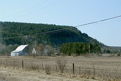
Rural scene along Ontario Highway 65 Hudson Twp ON 2.JPG
Rural scene along Ontario Highway 65

Government

The township is headed by a mayor and four councillors.


Infrastructure

The township has its own volunteer fire department, library at the Township Offices and a single municipal park with playground at Pike Lake Park. All other services are found in nearby New Liskeard including hospital and schools.

See also

Related Research Articles

<span class="mw-page-title-main">Timiskaming District</span> District in Ontario, Canada

Timiskaming is a district and census division in Northeastern Ontario in the Canadian province of Ontario. The district was created in 1912 from parts of Algoma, Nipissing, and Sudbury districts. In 1921, Cochrane District was created from parts of this district and parts of Thunder Bay District.

<span class="mw-page-title-main">Temiskaming Shores</span> City in Ontario, Canada

Temiskaming Shores is a city in the Timiskaming District in Northeastern Ontario, Canada. It was created by the amalgamation of the town of New Liskeard, the town of Haileybury, and the township of Dymond in 2004. The city had a total population of 9,634 in the Canada 2021 Census. Temiskaming Shores is Ontario's second-smallest city, in terms of population, after Dryden. Haileybury is the seat of Timiskaming District.

<span class="mw-page-title-main">Lake of Bays</span> Township municipality in Ontario, Canada

Lake of Bays is a township municipality within the District Municipality of Muskoka, Ontario, Canada. The township, situated 193 kilometres (120 mi) north of Toronto, is named after the Lake of Bays. During the 2016 census, the township had a population of 3,167 and encompassed 677.91 square kilometres (261.74 sq mi) of land.

<span class="mw-page-title-main">Marmora and Lake</span> Municipality in Ontario, Canada

Marmora and Lake is a municipality along the banks of Crowe River and Beaver Creek, about midway between Toronto and Ottawa on provincial Highway 7 in Hastings County in Central Ontario, Canada. It is home to over 4,000 full time and seasonal residents, many of whom enjoy outdoor recreation and relaxation on Crowe Lake.

<span class="mw-page-title-main">Trent Hills</span> Township in Ontario, Canada

The Municipality of Trent Hills is a township municipality in Northumberland County in Central Ontario, Canada. It is on the Trent River and was created in 2001 through the amalgamation of the municipalities of Campbellford/Seymour, Percy Township and Hastings. Thereafter it was known in brief as Campbellford/Seymour, Percy, Hastings.

<span class="mw-page-title-main">Laurentian Valley</span> Township municipality in Ontario, Canada

Laurentian Valley is a township municipality in Renfrew County in eastern Ontario, Canada. It borders on the Ottawa River, the city of Pembroke and the town of Petawawa.

<span class="mw-page-title-main">Latchford, Ontario</span> Town in Ontario, Canada

Latchford is a single-tier municipality town in Timiskaming District in Northeastern Ontario, Canada. It is located on Bay Lake on the Montreal River, near the town of Cobalt and the municipality of Temagami, and is 20 kilometres from the city of Temiskaming Shores. The population of the town in the Canada 2011 Census was 387, which makes it the smallest town by population in Ontario. The town's slogan is "The Best Little Town by a Dam Site!"

<span class="mw-page-title-main">Armour, Ontario</span> Township municipality in Ontario, Canada

Armour is a township municipality in the Canadian province of Ontario.

<span class="mw-page-title-main">Fauquier-Strickland</span> Township in Ontario, Canada

Fauquier-Strickland is a township municipality in Cochrane District in Northeastern Ontario, Canada. The three main communities in the township are Fauquier, Strickland, and Gregoires Mill. All are located along Ontario Highway 11 between the community of Departure Lake to the east and the municipality of Moonbeam to the west.

<span class="mw-page-title-main">Val Rita-Harty</span> Township municipality in Ontario, Canada

Val Rita-Harty is a township municipality in Cochrane District in Northeastern Ontario, Canada.

<span class="mw-page-title-main">Chapple, Ontario</span> Township municipality in Ontario, Canada

Chapple is a township municipality in Rainy River District in Northwestern Ontario, Canada.

<span class="mw-page-title-main">South Algonquin</span> Township municipality in Ontario, Canada

South Algonquin is a township municipality in Nipissing District, Ontario, Canada. Located south of Algonquin Provincial Park, it is the sole populated portion of the district that lies south of the traditional dividing line between Northern Ontario and Southern Ontario and is closer connected to Renfrew County as opposed to the core portions of Nipissing District.

<span class="mw-page-title-main">Gauthier, Ontario</span> Township municipality in Ontario, Canada

Gauthier is a township municipality in Timiskaming District the Northeastern Ontario, Canada. The township had a population of 138 in the Canada 2016 Census. Its main population centre is Dobie, located just north of Ontario Highway 66, 18.5 kilometres (11.5 mi) east of Kirkland Lake.

<span class="mw-page-title-main">Greater Madawaska</span> Township municipality in Ontario, Canada

Greater Madawaska is an incorporated township in Renfrew County in eastern Ontario, Canada, created on January 1, 2001, through the amalgamation of the Township of Bagot and Blythfield, the Township of Brougham, and the Township of Griffith and Matawatchan. As of 2021, it has a population of 2,864.

<span class="mw-page-title-main">Coleman, Ontario</span> Township municipality in Ontario, Canada

Coleman is a township municipality in the Canadian province of Ontario. It is situated in the Timiskaming District of Northeastern Ontario. The township had a population of 595 in the Canada 2016 Census.

<span class="mw-page-title-main">Harris, Ontario</span> Township in Ontario, Canada

Harris is a township in the Timiskaming District in the Canadian province of Ontario.

<span class="mw-page-title-main">Harley, Ontario</span> Township in Ontario, Canada

Harley is a township in the Canadian province of Ontario. Located within the Timiskaming District, Harley is located directly north of the city of Temiskaming Shores.

<span class="mw-page-title-main">James, Ontario</span> Township in Ontario, Canada

James is an incorporated township in the Canadian province of Ontario, located in Timiskaming District. The primary community within the township is Elk Lake, which is located at the junction of Ontario Highway 65 and Ontario Highway 560.

<span class="mw-page-title-main">Jogues, Ontario</span> Dispersed rural communityunincorporated area in Ontario, Canada

Jogues is a dispersed rural community and unincorporated place in geographic Way Township, Cochrane District in Northeastern Ontario, Canada. It is about 11 kilometres (6.8 mi) southwest of Hearst. Jogues is also a designated place served by a local services board.

<span class="mw-page-title-main">Hurkett</span> Dispersed rural community in Ontario, Canada

Hurkett is a dispersed rural community and unincorporated place in the Unorganized part of Thunder Bay District in northwestern Ontario, Canada. It is on Black Bay on the north shore of Lake Superior in geographic Stirling Township, and is on Ontario Highway 582, a short spur off Ontario Highway 17. Hurkett is a designated place served by a local services board, and has a population of 236.

References

  1. "Hudson". Geographical Names Data Base . Natural Resources Canada . Retrieved 2011-08-16.
  2. "Hudson". Geographical Names Data Base . Natural Resources Canada . Retrieved 2011-08-16.
  3. "Hudson". Atlas of Canada . Natural Resources Canada. 2010-02-04. Retrieved 2011-08-16. Shows township limits.
  4. Restructured municipalities - Ontario map #4 (Map). Restructuring Maps of Ontario. Ontario Ministry of Municipal Affairs and Housing. 2006. Archived from the original on 2014-04-10. Retrieved 2011-08-16.
  5. 1 2 Map 12 (PDF) (Map). 1 : 1,600,000. Official road map of Ontario. Ministry of Transportation of Ontario. 2010-01-01. Retrieved 2011-08-16.
  6. "Hillview". Geographical Names Data Base . Natural Resources Canada . Retrieved 2011-08-16.
  7. "History". Township of Hudson. 2003. Retrieved 2011-08-16. Excerpted from Hawirko, Norman R; Arnott, Margaret. "I've got to stop here until I'm called for".
  8. "Population and dwelling counts: Canada, provinces and territories, census divisions and census subdivisions (municipalities), Ontario". Statistics Canada. February 9, 2022. Retrieved April 2, 2022.
  9. "2021 Community Profiles". 2021 Canadian Census . Statistics Canada. February 4, 2022. Retrieved 2023-10-19.
  10. "2016 Community Profiles". 2016 Canadian Census . Statistics Canada. August 12, 2021. Retrieved 2020-12-23.
  11. "2011 Community Profiles". 2011 Canadian Census . Statistics Canada. March 21, 2019. Retrieved 2020-12-23.
  12. "2006 Community Profiles". 2006 Canadian Census . Statistics Canada. August 20, 2019.
  13. "2001 Community Profiles". 2001 Canadian Census . Statistics Canada. July 18, 2021.