
Omasuyos or Uma Suyu is a province in the La Paz Department in Bolivia. Its capital is Achacachi.

Ancohuma or Janq'u Uma is the third highest mountain in Bolivia. It is located in the northern section of the Cordillera Real, part of the Andes, east of Lake Titicaca. It lies just south of the slightly lower Illampu, near the town of Sorata.
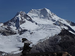
Chachacomani is a mountain in the Cordillera Real of the Andes Mountains, east of Lake Titicaca in Bolivia.

Patacamaya or Patak Amaya (Aymara) is a city in Bolivia, situated in the La Paz Department. It is the seat of the Patacamaya Municipality, the fifth municipal section of the Aroma Province. Patacamaya lies in the Altiplano, approximately 100 km southeast of La Paz. It contains the intersection between 'Carretera 1' which goes from La Paz to Oruro, as well as Cochabamba, and the 'Carretera Arica-La Paz'. The 'Tambo Quemado' highway is one of the most important international roads that travels through Bolivia.

Viacha Municipality is the first municipal section of the Ingavi Province in the La Paz Department, Bolivia. Its seat is Viacha.
Calacoto or Qala Qutu is the third municipal section of the Pacajes Province in the La Paz Department, Bolivia. Its seat is Calacoto.

Chearoco, Chiaraco or Chiaroco is a mountain in the Cordillera Real in the Andes of Bolivia. It has a height of about 6,127 m (20,102 ft). It is situated in the La Paz Department, Larecaja Province, Guanay Municipality, southeast of the peak of Aman Pata. Chearoco lies between Qalsata in the northwest and Chachakumani in the southeast.

Chaupi Orco or Viscachani is a mountain in the Andes on the border of Bolivia and Peru. It has a height of 6,044 metres (19,829 ft). On the Bolivian side it is located in the La Paz Department, Franz Tamayo Province, Pelechuco Municipality, and on the Peruvian side it lies in the Puno Region, Putina Province, Sina District. It lies north of Salluyu.
Nazacara or Nasa Q'ara is a village in the La Paz Department in Bolivia. It is the seat of the Nazacara Canton in the San Andrés de Machaca Municipality which is the fifth municipal section of the Ingavi Province.
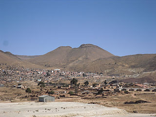
Caracollo, Q'araqullu or Q'ara Qullu is a small town in Bolivia. It is situated in the Cercado Province of the Oruro Department. In 2010 it had an estimated population of 5,429. Located at the place where the highway from La Paz splits into two roads towards Cochabamba and Oruro, the town is a frequent starting point for long marches intended to influence the Bolivian government.
Llallagua or Llallawa is a town in the Potosí Department in Bolivia. It is the seat of the Llallagua Municipality, the third municipal section of the Rafael Bustillo Province.
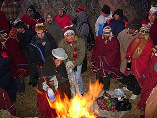
Willkakuti, Machaq Mara, Mara T'aqa, Jach'a Laymi or Pacha Kuti is an Aymara celebration in Bolivia, Chile and in the Southern Peru which takes place annually on 21 June, commemorating the winter solstice in the Southern Hemisphere.
Jachacunocollo, also known as Jacha Cuno Collo, Tres Marias, Don Luis or Jacha Collo is a mountain in the Andes in Bolivia. It is the highest elevation in the Quimsa Cruz Range reaching an elevation of about 5,800 metres (19,029 ft). Jachacunocollo is situated in the La Paz Department, Inquisivi Province, Quime Municipality, north-west of Wayna Khunu Qullu, the second highest mountain in this mountain range.
Wayna Khunu Qullu or Wayna Khunuqullu is one of the highest peaks in the Kimsa Cruz mountain range in the Andes of Bolivia. Its summit reaches about 5,640 metres (18,504 ft) above sea level.
Wila Lluxi is a mountain in the Andes, about 5,596 m (18,360 ft) high. It lies in the Cordillera Real of Bolivia in the La Paz Department, Los Andes Province, Batallas Municipality, Kirani Canton. It is situated on the western side of the Janq'u Quta valley next to the mountains Warawarani and Phaq'u Kiwuta. Other prominent mountains nearby are Janq'u Laya and Janq'u Uyu in the north, and Wila Lluxita and Mullu Apachita in the northeast, all of them higher than 5,000 m.
Phaq'u Kiwuta is a mountain in the Andes, about 5,589 m (18,337 ft) high. It is located in the Cordillera Real of Bolivia in the La Paz Department, Los Andes Province, Batallas Municipality, Kirani Canton. It is situated south-west of the mountain Wila Lluxi, south-east of Warawarani and north of a lake named Quta Thiya in some maps. Other prominent mountains nearby are Jisk'a Pata and Janq'u Uyu in the north, and Wila Lluxita and Mullu Apachita in the north-east, all of them higher than 5,000 m.
Uma Jalanta is a mountain in the Cordillera Real in the Andes of Bolivia, about 5,723 metres (18,776 ft) high. It is located in the La Paz Department, Larecaja Province, Sorata Municipality. It lies south-east of the mountains Janq'u Uma and Janq'u Piti, near the mountain Misk'i T'ant'a.
Wiluyu Janq'u Uma or Wiluyu is a mountain in the Cordillera Real in the Andes of Bolivia, about 5,540 metres (18,176 ft) high. It is located in the La Paz Department, Larecaja Province, Sorata Municipality. It lies northwest of the mountain Yapuchañani, northeast of Misk'i T'ant'a and Uma Jalanta and east of Illampu.

Layqa Qullu is a 6,166-metre-high (20,230 ft) peak in the Cordillera Real in the Andes of Bolivia. It is one of the highest peaks in the Illimani massif. It is situated in the La Paz Department, Murillo Province, Palca Municipality, and in the Sud Yungas Province, Irupana Municipality. Layqa Qullu lies south-east of the highest point of the massif, north-west of Link'u Link'u and Silla Pata.
The Cancañiri Formation, also named as Cancañiri Tillite, is a Katian to Hirnantian geologic formation of central Bolivia. The pebbly, argillaceous sandstones, shales and siltstones of the up to 1,500 metres (4,900 ft) thick formation, were deposited in a glacial foreshore to deep water turbiditic environment. The formation is named after Cancañiri, a mining town close to Llallagua, where a local legend of a possessed woman is believed. The formation overlies the San Benito Formation in Cochabamba and the Amutara Formation in other parts. The Cancañiri Formation is overlain by the Uncía Formation.

