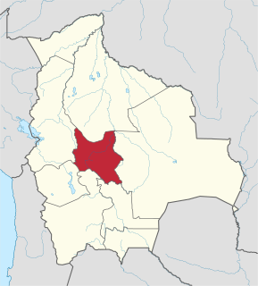
Arani is a province in Cochabamba Department, Bolivia. Its capital is Arani, situated about 53 km from Cochabamba. Arani is known for its bread but also for the town's artisan wickerwork.

Carrasco is a province in the Cochabamba Department in central Bolivia. Its capital is Totora.

Vacas Municipality is the second municipal section of the Arani Province in the Cochabamba Department in central Bolivia. Its capital is Vacas known as the "Land of the potato". During the Inca Empire Vacas served as a tampu along the Inca road system that led to Inkallaqta and Pocona.

Vacas is a Bolivian village in the southeast of the Cochabamba Department. It is the capital of the Vacas Municipality, the second municipal section of the Arani Province. Vacas is located about 85 km far from Cochabamba and about 30 km far from Arani.
Pocona Municipality is the third municipal section of the Carrasco Province in the Cochabamba Department in Bolivia. Its seat is Pocona. At the time of census 2001 the municipality had 13,488 inhabitants.

Phaqcha Mayu is a Bolivian river in the Cochabamba Department, Arani Province, Vacas Municipality, and in the Carrasco Province, Pocona Municipality. It originates near Vacas. From the lake Pilawit'u it flows southeast. Downstream, south of Pocona, it is also known under the name Ch'akiri.

Kuntur Wasi is a 5,272-metre-high (17,297 ft) mountain in the Andes of Bolivia. It is situated in the Potosí Department, Sud Lípez Province, San Pablo de Lípez Municipality. Kuntur Wasi lies north of the Lluch'a Mayu (Llucha Mayu) east of San Pablo de Lípez.
Qucha Quchayuq Urqu is a 4,304-metre-high (14,121 ft) mountain in the Bolivian Andes. It is located in the Cochabamba Department, the Carrasco Province, Pocona Municipality, near the border with the Arani Province, Vacas Municipality. Qucha Quchayuq Urqu lies on a ridge east of Vacas, southwest of Rumi Rumiyuq.
Wayra Wasi is a 4,416-metre-high (14,488 ft) mountain in the Bolivian Andes. It is situated in the Potosí Department, Tomás Frías Province, Potosí Municipality. Wayra Wasi lies west of Jatun Q'asa and the Ch'aki Mayu. The river originates southeast of the mountain. It flows to the north.
Jatun Q'asa is a 4,590-metre-high (15,059 ft) mountain in the Bolivian Andes. It is situated in the Potosí Department, Tomás Frías Province, Potosí Municipality. Some of the nearest settlements are Umallani and Salla K'uchu. Jatun Q'asa lies east Wayra Wasi, between the Ch'aki Mayu in the west and the Challwiri River (Challviri) in the east. Both rivers flow to the north as right tributaries of the Pillku Mayu.
Chullpa Ch'utu is a 3,748-metre-high (12,297 ft) mountain in the Bolivian Andes. It is located in the Cochabamba Department, Arani Province, Vacas Municipality, north of Vacas. The Jatun Mayu, a tributary of Parqu Qucha, flows along its western slope.
Llusk'a Llusk'a is a mountain in the Bolivian Andes which reaches a height of approximately 3,720 m (12,200 ft). It is located in the Cochabamba Department, Arani Province, Vacas Municipality, northwest of Vacas. The Jatun Mayu, a tributary of Parqu Qucha, flows along its eastern and southern slopes.
Jatun Salla is a 3,956-metre-high (12,979 ft) mountain in the Bolivian Andes. It is located in the Cochabamba Department, at the border of the Arani Province, Vacas Municipality, and the Carrasco Province, Pocona Municipality.
Rumi Rumiyuq is a mountain in the Bolivian Andes which reaches a height of approximately 4,160 m (13,650 ft). It is located in the Cochabamba Department, Carrasco Province, Pocona Municipality. Rumi Rumiyuq lies east of Qucha Quchayuq Urqu and southeast of Iskay Wasi.
P'isaqa is a mountain in the Bolivian Andes which reaches a height of approximately 3,200 m (10,500 ft). It is located in the Cochabamba Department, Carrasco Province, Pocona Municipality. It lies at the Wanaku Mayu.
Misk'i is a mountain in the Bolivian Andes which reaches a height of approximately 2,880 m (9,450 ft). It is located in the Cochabamba Department, Carrasco Province, Pocona Municipality. It lies at the Wanaku Mayu.
Yana Urqu is a mountain in the Bolivian Andes which reaches a height of approximately 3,200 m (10,500 ft). It is located in the Cochabamba Department, Carrasco Province, Pocona Municipality. It lies north of the Wanaku Mayu.
Inka Wasi is a 3,146-metre-high (10,322 ft) mountain in the Bolivian Andes. It is located in the Chuquisaca Department, Azurduy Province, Tarvita Municipality. Inka Wasi lies southwest of Muyu Urqu and north of Pukara. The Laqha Mayu originates north of the mountain. Its waters flow to the Pillku Mayu.
Muru Wasi is a mountain in the Bolivian Andes which reaches a height of approximately 4,180 m (13,710 ft). It is located in the Potosí Department, José María Linares Province, Caiza "D" Municipality, near the border to the Antonio Quijarro Province, Porco Municipality. Muru Wasi lies southwest of Lluqu LLuqu. The Uqururu Mayu flows along its southern slope.
Jatun Ch'utu is a mountain in the Bolivian Andes which reaches a height of approximately 4,220 m (13,850 ft). It is located in the Potosí Department, Tomás Frías Province, Potosí Municipality. It lies southeast of the village of Juch'uy Wasi (Juchuy Huasi). The Jatun Mayu flows along its southern slopes.