Kamrup Rural district, or simply Kamrup district, is an administrative district in the state of Assam in India formed by dividing the old Kamrup district into two in the year 2003; other being Kamrup Metropolitan district, named after the region it constitutes. This district, along with Nalbari, Barpeta, Kamrup Metropolitan, Bajali and Baksa districts has been created from the Undivided Kamrup district.

Nalbari is a town and a municipal board in Nalbari district in the Indian state of Assam. Nalbari town is also the headquarters of Nalbari District. The town is one of many towns covered under the proposed State capital region.
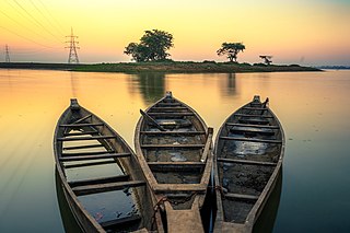
Pan Bazaar is a locality in Guwahati, India surrounded by localities of Paltan Bazaar, Ambari and Fancy Bazaar. Situated on the banks of the river Brahmaputra, it is part of the city centre.
Pirganj is an upazila of Rangpur District in the division of Rangpur, Bangladesh. Pirganj Upazila area 409.37 km2, located in between 25°18' and 25°31' north latitudes and in between 89°08' and 89°25' east longitudes. It is bounded by mithapukur upazila on the north, Palashbari, Ghoraghat and Nawabganj Sadar (Dinajpur) upazilas on the south, Sadullapur upazila on the east, Mithapukur, Nawabganj Sadar (Dinajpur) and Ghoraghat upazilas on the west.
Jajuara, also written Jajuar and Yajuar, is the largest village in the Muzaffarpur district of Bihar in India, and the second-largest village in Bihar.

The Karbi language is spoken by the Karbi people of Northeastern India.

Kamrup Metropolitan district is one of the 35 districts in Assam state in north-eastern India. It was carved out of the erstwhile undivided Kamrup district in 2003 and covers an area equivalent to the area under the jurisdiction of the Guwahati Metropolitan Development Authority area. Dispur Legislative Assembly Constituency in Kamrup Metro district with 3.53 lakh voters is the largest constituency in Assam.
Baihata Chariali is an out growth urban centre of Guwahati City in Kamrup Rural district of Assam, India; situated at norther site of the river Brahmaputra. The place is called Chariali as it is a major road junction where National Highway 27 interconnect with National Highway 15.
Chaygaon is a town in Kamrup district of Assam, India; situated on the south bank of the Brahmaputra river. It is 36.8 km from major town Guwahati. The town is known for "Maa Chandika Devalaya", a Shakti Peeth, where thousands of devotees visit during Durga Puja. Historical "Mer Ghar" of Chand Sadagar situated in Champak Nagar, Chaygaon.
Kumirkola is a village in Khandaghosh CD Block in Bardhaman Sadar South subdivision of Purba Bardhaman district in West Bengal, India.
Kamrupi dialects are a group of regional dialects of Assamese, spoken in the Kamrup region. It formerly enjoyed prestige status. It is one of two western dialect groups of the Assamese language, the other being Goalpariya. Kamrupi is heterogeneous with three subdialects— Barpetia dialect, Nalbariya dialect and Palasbaria dialect.

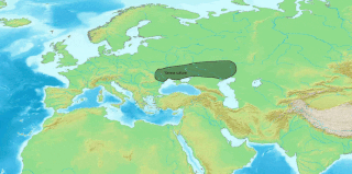
Kamrup is the modern region situated between two rivers, the Manas and the Barnadi in Western Assam, with the same territorial extent as the Colonial and post-Colonial "Undivided Kamrup district". It was the capital region of two of the three dynasties of Kamarupa and Guwahati, the current political center of Assam, is situated here. It is characterized by its cultural artifacts.
Deuduar is a mid-sized village located in the district of Kamrup in the state of Assam in India. It has a population of about 3500 persons living in around 300 households. It is situated almost 30 km away Guwahati. The 31 natioanal highway goes through midflr of this village. Most of the villagers are farmers. Some are stonecutters. There has been gradual destruction of Gopeshwar Hill by stonecutters.
Kamrupi culture refers to the cultural norms of people of colonial Kamrup district.

Lower Assam division is one of the 5 administrative divisions of Assam. It was formed in 1874, comprising Undivided Kamrup district of Western Assam, undivided Darrang and Nagoan districts of Central Assam and Khasi & Jaintia hills of Meghalaya, created for revenue purposes. The division is under the jurisdiction of a Commissioner, who is stationed at Guwahati. The division currently covers Western Brahmaputa Valley. Shri Jayant Narlikar,IAS is the current Commissioner of Lower Assam division.
Deodhani dance is a Shaman folk dance from the Indian state of Assam. It can be performed either solo or in a group. Deodhani is of Boro-kachari origin. A group performance of Deodhani generally consists of three or four women. The dance form is associated with the worship of the snake goddess Manasa or Marei/Maroi. A Deodhani dance is generally performed to the accompaniment of songs sung by an oja, an Assamese traditional chorus leader, in the Darrang district.
The Kamrupi people are a linguistic group that speak the Kamrupi dialects of Assamese and are found in the colonial Kamrup district region of Assam, India.
Radha Kuchi is a village near the town of Baihata, Kamrup district, Assam, India.
Sonkuriha, 'Suvarnakundya' in ancient times, is a village in Nalbari district of Western Assam.

