Kampung Jangalas

Last updated
Kampung Jangalas
Borneo Locator Topography.png
Red pog.svg
Kampung Jangalas
Coordinates: 4°04′00″N113°50′00″E / 4.06667°N 113.83333°E / 4.06667; 113.83333 Coordinates: 4°04′00″N113°50′00″E / 4.06667°N 113.83333°E / 4.06667; 113.83333
Country Flag of Malaysia.svg  Malaysia
State Flag of Sarawak.svg  Sarawak
Administrative Division Miri
Elevation
1 m (3 ft)

Kampung Jangalas is a settlement in the Miri division of Sarawak, Malaysia. [1] [2] It lies approximately 477.2 kilometres (297 mi) northeast of the state capital Kuching.

Miri Division Place

Miri Division is one of the twelve administrative divisions of Sarawak, Malaysia. It has a total area of 26,777.1 square kilometres, and is the second largest division after Kapit Division.

Sarawak State of Malaysia

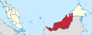
Sarawak is a state of Malaysia. The largest among the 13 states, with an area almost equal to that of Peninsular Malaysia, Sarawak is located in northwest Borneo Island, and is bordered by the Malaysian state of Sabah to the northeast, Kalimantan to the south, and Brunei in the north. The capital city, Kuching, is the largest city in Sarawak, the economic centre of the state, and the seat of the Sarawak state government. Other cities and towns in Sarawak include Miri, Sibu, and Bintulu. As of the 2015 census, the population of Sarawak was 2,636,000. Sarawak has an equatorial climate with tropical rainforests and abundant animal and plant species. It has several prominent cave systems at Gunung Mulu National Park. Rajang River is the longest river in Malaysia; Bakun Dam, one of the largest dams in Southeast Asia, is located on one of its tributaries, the Balui River. Mount Murud is the highest point in Sarawak.

Malaysia Federal constitutional monarchy in Southeast Asia

Malaysia is a country in Southeast Asia. The federal constitutional monarchy consists of 13 states and three federal territories, separated by the South China Sea into two similarly sized regions, Peninsular Malaysia and East Malaysia. Peninsular Malaysia shares a land and maritime border with Thailand and maritime borders with Singapore, Vietnam, and Indonesia. East Malaysia shares land and maritime borders with Brunei and Indonesia and a maritime border with the Philippines and Vietnam. Kuala Lumpur is the national capital and largest city while Putrajaya is the seat of federal government. With a population of over 30 million, Malaysia is the world's 44th most populous country. The southernmost point of continental Eurasia, Tanjung Piai, is in Malaysia. In the tropics, Malaysia is one of 17 megadiverse countries, with large numbers of endemic species.

Neighbouring settlements include:

Kampung Manjelin Place in Sarawak, Malaysia

Kampung Menjelin is a settlement in the Miri division of Sarawak, Malaysia. It lies approximately 478.3 kilometres (297 mi) northeast of the state capital Kuching.

Kampung Angus Place in Sarawak, Malaysia

Kampung Angus is a settlement in the Miri division of Sarawak, Malaysia. It lies approximately 476.8 kilometres (296 mi) northeast of the state capital Kuching.

Kampung Tengah is a small town and village in Segamat District, Johor, Malaysia. Kampung Tengah is divided into two main settlements - the Malay village side and the Chinese New Village - where both settlements are separated by Sungai Kapeh.

Related Research Articles

Tebedu Place in Sarawak, Malaysia

Tebedu is a border town in the Serian division of southwestern Sarawak, Malaysia, on the Indonesia-Malaysia border. It lies approximately 63.2 kilometres (39 mi) south of the state capital Kuching.

Simunjan District Place in Sarawak, Malaysia

The Simunjan District is a district in the Simunjan division of Sarawak, Malaysia, located between Serian and Sri Aman. It borders Sebuyau and Samarahan and lies approximately 51.4 kilometres (32 mi) east-south-east of the state capital Kuching.

Tebakang Place in Sarawak, Malaysia

Tebakang is a village in the Serian division of Sarawak, Malaysia, between Serian and Tebedu. It is about 15 minutes drive from Serian Town. Tebakang lies approximately 56.9 kilometres (35 mi) south-south-east of the state capital Kuching.

Bekenu Place in Sarawak, Malaysia

Bekenu is a small fishing town near Miri, in Sarawak, Malaysia. It lies approximately 477.6 kilometres (297 mi) northeast of the state capital Kuching.

Tundong Place in Sarawak, Malaysia

Tondong is a settlement on the Sarawak Kanan river in the Bau division of Sarawak, Malaysia. It lies approximately 25.2 kilometres (16 mi) southwest of the state capital Kuching.

Kampung Sabang Place in Sarawak, Malaysia

Kampung Sabang is a settlement in the Simunjan division of Sarawak, Malaysia. It lies approximately 44.8 kilometres (28 mi) east-south-east of the state capital Kuching.

Kampung Munti Place in Sarawak, Malaysia

Kampung Munti is a settlement in the Lundu division of Sarawak, Malaysia. It lies approximately 54.3 kilometres (34 mi) west of the state capital Kuching.

Kampung Melikat Place in Sarawak, Malaysia

Kampung Melikat is a settlement in the Marudi division of Sarawak, Malaysia. It lies approximately 530.8 kilometres (330 mi) east-north-east of the state capital Kuching.

Kampung Alit Place in Sarawak, Malaysia

Kampung Alit is a settlement in the Saratok division of Sarawak, Malaysia. It lies approximately 100.6 kilometres (63 mi) east-north-east of the state capital Kuching.

Kampung Sasam Place in Sarawak, Malaysia

Kampung Sasam is a settlement in the Miri division of Sarawak, Malaysia. It lies approximately 479.3 kilometres (298 mi) northeast of the state capital Kuching.

Long Tuma Place in Sarawak, Malaysia

Long Tuma is a settlement in the Lawas division of Sarawak, Malaysia. It lies approximately 667.1 kilometres (415 mi) east-north-east of the state capital Kuching.

Long Sabuloh Place in Sarawak, Malaysia

Long Sabuloh is a settlement in the Lawas division of Sarawak, Malaysia. It lies approximately 665.1 kilometres (413 mi) east-north-east of the state capital Kuching.

Kampung Gaya Place in Sarawak, Malaysia

Kampung Gaya is a settlement in the Lawas division of Sarawak, Malaysia. It lies approximately 669.1 kilometres (416 mi) east-north-east of the state capital Kuching.

Kampung Sitakong Place in Sarawak, Malaysia

Kampung Sitakong is a settlement in the Lawas division of Sarawak, Malaysia. It lies approximately 671.7 kilometres (417 mi) east-north-east of the state capital Kuching.

Kampung Pangaleh Place in Sarawak, Malaysia

Kampung Pangaleh is a settlement in the Lawas division of Sarawak, Malaysia. It lies approximately 672.8 kilometres (418 mi) east-north-east of the state capital Kuching.

Kampung Puteh Place in Sarawak, Malaysia

Kampung Puteh is a settlement in the Lawas division of Sarawak, Malaysia. It lies approximately 677.7 kilometres (421 mi) east-north-east of the state capital Kuching.

Long Remirang Place in Sarawak, Malaysia

Long Remirang is a settlement in the Lawas division of Sarawak, Malaysia. It lies approximately 660.3 kilometres (410 mi) east-north-east of the state capital Kuching.

Long Sukang Place in Sarawak, Malaysia

Long Sukang is a Lun Bawang settlement in the Lawas division of Sarawak, Malaysia. It lies approximately 660.7 kilometres (411 mi) east-north-east of the state capital Kuching.

References

  1. M. Mohizah, S. Julia and W. K. Soh (2006). A Sarawak Gazetteer (PDF). Kuala Lumpur: Sarawak Forestry Department Malaysia and Forest Research Institute Malaysia. ISBN   983-2181-86-0. OCLC   85818866. Archived from the original (PDF) on 2011-07-22. Retrieved 2011-01-01.
  2. "Kampung Jangalas, Malaysia". Geonames. 1994-02-10. Retrieved 2010-12-27.