Related Research Articles

The Tejon Pass, previously known as Portezuelo de Cortes, Portezuela de Castac, and Fort Tejon Pass is a mountain pass between the southwest end of the Tehachapi Mountains and northeastern San Emigdio Mountains, linking Southern California north to the Central Valley. Both the pass and the grade north of it to the Central Valley are commonly referred to as "the Grapevine". It has been traversed by major roads such as the El Camino Viejo, the Stockton – Los Angeles Road, the Ridge Route, U.S. Route 99, and now Interstate 5.
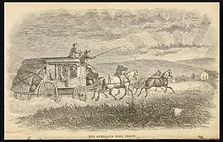
Butterfield Overland Mail was a stagecoach service in the United States operating from 1858 to 1861. It carried passengers and U.S. Mail from two eastern termini, Memphis, Tennessee, and St. Louis, Missouri, to San Francisco, California. The routes from each eastern terminus met at Fort Smith, Arkansas, and then continued through Indian Territory (Oklahoma), Texas, New Mexico, Arizona, Mexico, and California ending in San Francisco. On March 3, 1857, Congress authorized the U.S. postmaster general, at that time Aaron V. Brown, to contract for delivery of the U.S. mail from St. Louis to San Francisco. Prior to this, U.S. Mail bound for the Far West had been delivered by the San Antonio and San Diego Mail Line since June 1857.

San Francisquito Canyon is a canyon created through erosion of the Sierra Pelona Mountains by the San Francisquito Creek, in Los Angeles County, Southern California.

Lake Hughes is an unincorporated community in northern Los Angeles County, California. It is in the Sierra Pelona Mountains, northwest of Palmdale and north of the Santa Clarita Valley, in the Angeles National Forest. It is on the sag pond waters of Lake Hughes and Elizabeth Lake. The community is rural in character, with a population of 649 in 2010, but also has a strong recreational element centered on the three lakes in the vicinity. The community of Elizabeth Lake is located just east of Lake Hughes, sharing the same ZIP code.
Santa Clarita is a city in northwestern Los Angeles County in the U.S. state of California. With a 2020 census population of 228,673, it is the third-most populous city in Los Angeles County, the 17th-most populous in California, and the 103rd-most populous city in the United States. It is located about 30 miles (48 km) northwest of downtown Los Angeles, and occupies 70.75 square miles (183.2 km2) of land in the Santa Clarita Valley, along the Santa Clara River. It is a classic example of a U.S. edge city, satellite city, or boomburb.
Warner's Ranch, near Warner Springs, California, was notable as a way station for large numbers of emigrants on the Southern Emigrant Trail from 1849 to 1861, as it was a stop on both the Gila River Trail and the Butterfield Overland Mail stagecoach line (1859-1861). It was also operated as a pioneering cattle ranch.

Oak Grove Butterfield Stage Station is located in the western foothills of the Laguna Mountains, in northern San Diego County, California. It is located on State Route 79, 13 miles (21 km) northwest of Warner Springs and Warner's Ranch. The station was built on the site of Camp Wright, an 1860s Civil War outpost.
Warner Springs is set of springs and a small unincorporated community in northern San Diego County, California. It is on the Pacific Crest Trail.

Green Valley is a census-designated place in the Sierra Pelona Mountains, in Los Angeles County, California. It lies at an elevation of 2936 feet. The population was 1,027 at the 2010 census.

Rancho Temescal was a farming outpost of Mission San Luis Rey de Francia, one of the 21 Franciscan missions established in California by Spain during the late 18th and early 19th centuries. The Mission was located on the coast where Oceanside, California, is today. The Rancho was settled in 1819 by Leandro Serrano, and became the first non-native settlement within the boundaries of what would become Riverside County, California.
The Butterfield Overland Mail in California was created by the United States Congress on March 3, 1857, and operated until June 30, 1861. Subsequently, other stage lines operated along the Butterfield Overland Mail in route in Alta California until the Southern Pacific Railroad arrived in Yuma, Arizona in 1877.

The Lyons Station Stagecoach Stop,, was a tavern and stagecoach stop near the southwest corner of Newhall Avenue and Sierra Highway, by Eternal Valley Cemetery. The site is located in the present day Newhall section of Santa Clarita, in Los Angeles County, California.
The Stockton–Los Angeles Road, also known as the Millerton Road, Stockton–Mariposa Road, Stockton–Fort Miller Road or the Stockton–Visalia Road, was established about 1853 following the discovery of gold on the Kern River in Old Tulare County. This route between Stockton and Los Angeles followed by the Stockton–Los Angeles Road is described in "Itinerary XXI. From Fort Yuma to Benicia, California", in The Prairie Traveler: A Hand-book for Overland Expeditions by Randolph Barnes Marcy. The Itinerary was derived from the report of Lieutenant R. S. Williamson on his topographical survey party in 1853, that was in search of a railroad route through the interior of California.

San Francisquito Creek, in Los Angeles County, is a tributary stream of the Santa Clara River. It drains the south facing slopes of the Sierra Pelona Mountains of the San Gabriel Mountains within the Transverse Range of California, United States.
San Francisquito Pass is a mountain pass in the Sierra Pelona Mountains, located northeast of Green Valley and Santa Clarita, in northern Los Angeles County, California.
Tejon Creek, originally in Spanish Arroyo de Tejon, is a stream in Kern County, California. Its headwaters are located on the western slopes of the Tehachapi Mountains, and it flows northwest into the southern San Joaquin Valley.
Mud Spring, formerly called Aquaje Lodoso, is a spring and historic site in the western Antelope Valley, within northern Los Angeles County, southern California.
Widow Smith's Station, also known as Major Gordon's Station and Clayton's Station, was a stagecoach station of the Butterfield Overland Mail 1st Division from 1858 to 1861 in southern California.
Cottonwoods Station was a stop on the San Antonio-San Diego Mail Line and later the Butterfield Overland Mail stagecoach station in El Paso County, Texas.
Cow Springs Ranch, formerly Ojo de Vaca Station, is a ranch headquartered at Cow Springs in Luna County, New Mexico, originally Ojo de Vaca when it was a Butterfield Overland Mail stagecoach station at Ojo de Vaca, in New Mexico Territory. It was located 14 mi (23 km) northeast of Soldiers Farewell Station and 16 mi (26 km) southwest of Miembre's River Station, later Mowry City.
References
- 1 2 List of Butterfield Overland Mail Stations, from New York Times, October 14 1858, "Itinerary of the Route"
- 1 2 Waterman L. Ormsby, Lyle H. Wright, Josephine M. Bynum, The Butterfield Overland Mail: Only Through Passenger on the First Westbound Stage. Henry E. Huntington Library and Art Gallery, 2007. pp. viii, 167, 173.
- ↑ Google Maps
- ↑ Notes of a Trip to Los Angeles No. 1, Daily Alta California, Volume 12, Number 3888, 5 October 1860 — Page 1
- ↑ THE STORY OF OUR VALLEY BY A.B. PERKINS, 4. Early Transportation, Six White Horses
- ↑ Frickstad, Walter N., A Century of California Post Offices 1848-1954, Philatelic Research Society, Oakland, CA. 1955, pp. 70-84.
- ↑ Santa Clarita Valley Historical Society: "Raggio Ranch, San Francisquito Canyon"
- ↑ Santa Clarita Valley Historical Society: Photo of St. Francis Dam Floodpath — "on the hillside in the distance (looking west), the Ruiz family cemetery can barely be discerned. Moore's stagecoach stop, ... later known as "Holland's" or "Hollandsville," was located just below the cemetery."
- ↑ www.findagrave.com, Ruiz-Perea Family Cemetery
- ↑ Raggio Ranch, San Franciscquito Canyon