Kioma, Queensland

Last updated

Kioma
Queensland
Australia Queensland location map.svg
Red pog.svg
Kioma
Coordinates 28°13′11″S149°47′56″E / 28.2197°S 149.7988°E / -28.2197; 149.7988 (Kioma (centre of locality))
Population32 (2021 census) [1]
 • Density0.1060/km2 (0.274/sq mi)
Postcode(s) 4498
Area302.0 km2 (116.6 sq mi)
Time zone AEST (UTC+10:00)
Location
LGA(s) Goondiwindi Region
State electorate(s) Southern Downs
Federal division(s) Maranoa
Suburbs around Kioma:
Tarawera Tarawera Lundavra
Tarawera Kioma Toobeah
Bungunya Bungunya Toobeah

Kioma is a rural locality in the Goondiwindi Region, Queensland, Australia. [2] In the 2021 census, Kioma had a population of 32 people. [1]

Contents

Geography

The Meandarra – Talwood Road (State Route 74) forms part of the western boundary.

History

John Hubert Fairfax established Kioma Station in the early twentieth century. [3] He was a grandson of John Fairfax, one of the early proprietors of The Sydney Morning Herald , and his wife was Ruth Fairfax (née Dowling), a founding member of the Australian Country Women's Association.

Kioma State School opened on 9 November 1959 in response to a request from the managers of "Kioma" Station. [4] [5]

Demographics

In the 2016 census, Kioma had a population of 30 people. [6]

In the 2021 census, Kioma had a population of 32 people. [1]

Economy

There are a number of homesteads in the locality:

Kioma Station has an airstrip ( 28°13′13″S149°47′39″E / 28.2202°S 149.7943°E / -28.2202; 149.7943 (Kioma Airstrip) ) adjacent to the school. [9]

Education

Kioma State School is a government primary (Prep-6) school for boys and girls at Kioma Road ( 28°13′02″S149°47′38″E / 28.2172°S 149.7940°E / -28.2172; 149.7940 (Kioma State School) ). [10] [11] In 2018, the school had an enrolment of 15 students with 3 teachers (2 full-time equivalent) and 5 non-teaching staff (2 full-time equivalent). [12]

There is no secondary school in Kioma. The nearest is Goondiwindi State High School in Goondiwindi to the south-east but at such a distance that distance education and boarding school would be other options. [13]

Related Research Articles

<span class="mw-page-title-main">Texas, Queensland</span> Town in Queensland, Australia

Texas is a rural town and locality in the Goondiwindi Region of Queensland, Australia. It is on the Queensland border with New South Wales. In the 2021 census, the locality of Texas had a population of 790 people.

<span class="mw-page-title-main">Goondiwindi</span> Town in Queensland, Australia

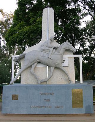
Goondiwindi is a rural town and locality in the Goondiwindi Region, Queensland, Australia. It is on the border of Queensland and New South Wales. In the 2016 census, Goondiwindi had a population of 6,355 people.

Federal is a rural locality in the Shire of Noosa, Queensland, Australia. It is located in the Sunshine Coast hinterland near the towns of Cooran and Pomona. In the 2021 census, Federal had a population of 365 people.

<span class="mw-page-title-main">Moonie, Queensland</span> Town in Queensland, Australia

Moonie is a rural town in the Western Downs Region and a locality split between the Western Downs Region and the Goondiwindi Region in Queensland, Australia. In the 2016 census, the locality of Moonie had a population of 189 people.

<span class="mw-page-title-main">Glenmorgan, Queensland</span> Town in Queensland, Australia

Glenmorgan is a rural town in the Western Downs Region and a locality split between the Western Downs Region and the Maranoa Region, Queensland, Australia. In the 2016 census the locality of Glenmorgan had a population of 148 people.

<span class="mw-page-title-main">Gogango</span> Town in Queensland, Australia

Gogango is a rural town and locality in the Rockhampton Region, Queensland, Australia. In the 2016 census the locality of Gogango had a population of 111 people.

Westmar is a rural locality in the Western Downs Region, Queensland, Australia. In the 2016 census, Westmar had a population of 64 people.

<span class="mw-page-title-main">Bungunya, Queensland</span> Suburb of Goondiwindi Region, Queensland, Australia

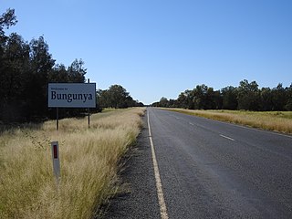
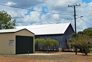
Bungunya is a rural town and locality in the Goondiwindi Region, Queensland, Australia. The locality is on the border of Queensland and New South Wales. In the 2016 census, Bungunya had a population of 75 people.

<span class="mw-page-title-main">Beebo, Queensland</span> Suburb of Goondiwindi Region, Queensland, Australia

Beebo is a rural locality in the Goondiwindi Region, Queensland, Australia. It is on the Queensland border with New South Wales. In the 2021 census, Beebo had a population of 50 people.

<span class="mw-page-title-main">Glenarbon, Queensland</span> Suburb of Goondiwindi Region, Queensland, Australia

Glenarbon is a rural locality in the Goondiwindi Region, Queensland, Australia. It is on the border of Queensland and New South Wales. In the 2021 census, Glenarbon had a population of 33 people.

Kurumbul is a rural town and locality in the Goondiwindi Region, Queensland, Australia. It is on the border of Queensland and New South Wales. In the 2016 census, Kurumbul had a population of 46 people.

Limevale is a rural locality in the Goondiwindi Region, Queensland, Australia. In the 2021 census, Limevale had a population of 49 people.

Mosquito Creek is a rural locality in the Goondiwindi Region, Queensland, Australia. In the 2016 census Mosquito Creek had a population of 17 people.

North Bungunya is a rural locality in the Goondiwindi Region, Queensland, Australia. In the 2016 census North Bungunya had a population of 39 people.

South Talwood is a rural locality in the Goondiwindi Region, Queensland, Australia. It is on the border of Queensland and New South Wales. It is 107 kilometres (66 mi) west of Goondiwindi. In the 2021 census, South Talwood had a population of 101 people.

<span class="mw-page-title-main">Talwood, Queensland</span> Town in Queensland, Australia

Talwood is a town in the rural locality of North Talwood in Goondiwindi Region, Queensland, Australia.

Tarawera is a rural locality in the Goondiwindi Region, Queensland, Australia. In the 2016 census Tarawera had a population of 39 people.

Mentmore is a coastal locality in the Mackay Region, Queensland, Australia. In the 2021 census, Mentmore had "no people or a very low population".

Kinnoul is a rural locality in the Shire of Banana, Queensland, Australia. In the 2021 census, Kinnoul had a population of 80 people.

Humboldt is a rural locality in the Central Highlands Region, Queensland, Australia. In the 2021 census, Humboldt had a population of 49 people.

References

  1. 1 2 3 Australian Bureau of Statistics (28 June 2022). "Kioma (SAL)". 2021 Census QuickStats. Retrieved 28 February 2023. OOjs UI icon edit-ltr-progressive.svg
  2. "Kioma – locality in Goondiwindi Region (entry 47815)". Queensland Place Names. Queensland Government . Retrieved 14 December 2020.
  3. "Obituary - John Hubert Fairfax". Obituaries Australia. 11 June 1950. Archived from the original on 6 May 2019. Retrieved 6 May 2019.
  4. "Little school is facing the axe". Warwick Daily News. 22 July 2009. Archived from the original on 6 May 2019. Retrieved 6 May 2019.
  5. Queensland Family History Society (2010), Queensland schools past and present (Version 1.01 ed.), Queensland Family History Society, ISBN   978-1-921171-26-0
  6. Australian Bureau of Statistics (27 June 2017). "Kioma (SSC)". 2016 Census QuickStats. Retrieved 20 October 2018. OOjs UI icon edit-ltr-progressive.svg
  7. 1 2 "Homesteads - Queensland". Queensland Open Data. Queensland Government. 18 November 2020. Archived from the original on 24 November 2020. Retrieved 24 November 2020.
  8. "JH Fairfax and Son". Yellow Pages. Archived from the original on 14 December 2020. Retrieved 6 May 2019.
  9. "Heliports and landing grounds - Queensland". Queensland Open Data. Queensland Government. 22 October 2020. Archived from the original on 16 November 2020. Retrieved 3 November 2020.
  10. "State and non-state school details". Queensland Government. 9 July 2018. Archived from the original on 21 November 2018. Retrieved 21 November 2018.
  11. "Kioma State School". Archived from the original on 26 March 2020. Retrieved 21 November 2018.
  12. "ACARA School Profile 2018". Australian Curriculum, Assessment and Reporting Authority. Archived from the original on 27 August 2020. Retrieved 28 January 2020.
  13. "Queensland Globe". State of Queensland . Retrieved 14 December 2020.

Further reading