
Texas is a rural town and locality in the Goondiwindi Region of Queensland, Australia. It is on the Queensland border with New South Wales. In the 2021 census, the locality of Texas had a population of 790 people.
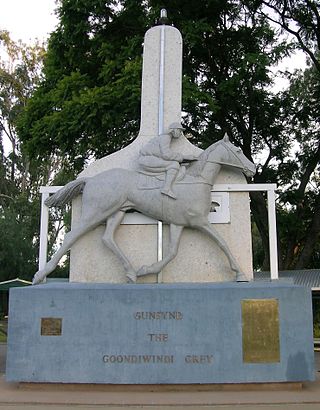
Goondiwindi is a rural town and locality in the Goondiwindi Region, Queensland, Australia. It is on the border of Queensland and New South Wales. In the 2016 census, Goondiwindi had a population of 6,355 people.

Kinka Beach is a coastal rural locality in the Livingstone Shire, Queensland, Australia. In the 2021 census, Kinka Beach had a population of 674 people.

Curra is a rural residential locality in the Gympie Region, Queensland, Australia. In the 2021 census, Curra had a population of 2,104 people.
Billa Billa is a rural locality in the Goondiwindi Region, Queensland, Australia. In the 2021 census, Billa Billa had a population of 111 people.
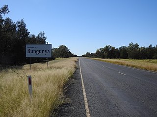
Bungunya is a rural town and locality in the Goondiwindi Region, Queensland, Australia. The locality is on the border of Queensland and New South Wales. In the 2016 census, Bungunya had a population of 75 people.

Beebo is a rural locality in the Goondiwindi Region, Queensland, Australia. It is on the Queensland border with New South Wales. In the 2021 census, Beebo had a population of 50 people.
Calingunee is a rural locality in the Goondiwindi Region, Queensland, Australia. In the 2021 census, Calingunee had a population of 18 people.
Callandoon is a rural locality in the Goondiwindi Region, Queensland, Australia. It is on the border of Queensland and New South Wales. In the 2021 census, Callandoon had a population of 32 people.

Coolmunda is a rural locality in the Goondiwindi Region, Queensland, Australia. In the 2021 census, Coolmunda had a population of 212 people.
Daymar is a rural town and locality in the Goondiwindi Region, Queensland, Australia. In the 2016 census, the locality of Daymar had a population of 37 people.
Kioma is a rural locality in the Goondiwindi Region, Queensland, Australia. In the 2021 census, Kioma had a population of 32 people.
Kurumbul is a rural town and locality in the Goondiwindi Region, Queensland, Australia. It is on the border of Queensland and New South Wales. In the 2016 census, Kurumbul had a population of 46 people.
Mosquito Creek is a rural locality in the Goondiwindi Region, Queensland, Australia. In the 2016 census Mosquito Creek had a population of 17 people.

Oman Ama is a rural locality in the Goondiwindi Region, Queensland, Australia. In the 2016 census, Oman Ama had a population of 38 people.
South Talwood is a rural locality in the Goondiwindi Region, Queensland, Australia. It is on the border of Queensland and New South Wales. It is 107 kilometres (66 mi) west of Goondiwindi. In the 2021 census, South Talwood had a population of 101 people.

Talwood is a town in the rural locality of North Talwood in Goondiwindi Region, Queensland, Australia.
Callide is a rural town and locality in the Shire of Banana, Queensland, Australia. In the 2016 census, the locality of Callide had a population of 86 people.
Dakenba is a rural locality in the Shire of Banana, Queensland, Australia. In the 2021 census, Dakenba had a population of 127 people.

Kianga is a rural locality in the Shire of Banana, Queensland, Australia. In the 2021 census, Kianga had a population of 219 people.
