Koome Island

Last updated
Sunrise on Koome A Mother In A Fishing Village.jpg
Sunrise on Koome

Koome is an island in Lake Victoria, Uganda.

Location

Koome Island is located in Mukono District, in northwestern Lake Victoria, in Uganda. The island is separated to Ssese Islands by the Koome Channel. Koome is the largest island in the northeastern group. Other islands in the same group include: Damba Island, Lwaje Island, Ngamba-Chimpanzee Island, Bulago Island, Kayaga Island and others. This location lies approximately 63 kilometres (39 mi), by water, northeast of Kalangala. [1] Koome also lies approximately 35 kilometres (22 mi), by water, southeast of Entebbe, the nearest large town. [2] The coordinates of Koome Island are:00 05 06S, 32 45 00E (Latitude:-0.0850; Longitude:32.7500).

Contents

Urban areas

The largest urban area on the island is called Bugombe, located on the northwestern shore of the island. There is a health center on the island, Koome Health Center III, not far from Bugombe. In February 2011, PostBank Uganda announced that they will soon open a brick and mortar branch on Koome Island. [3]

Economic activities

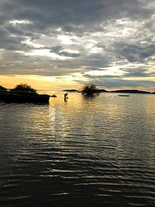
The principal economic activity on Koome, as is the case with most adjacent islands in the Ssese Islands is fishing. Nile Perch is the species primarily fished, with most of the catch processed on the mainland for export. Overfishing is a concern. Other economic activities include agriculture, both crop and animal husbandry, logging and tourism.

See also

Related Research Articles

<span class="mw-page-title-main">Transport in Uganda</span>

Transport in Uganda refers to the transportation structure in Uganda. The country has an extensive network of paved and unpaved roads.

<span class="mw-page-title-main">Entebbe</span> Place in Central Uganda, Uganda

Entebbe is a city in Central Uganda. Located on a Lake Victoria peninsula, approximately 36 kilometres (22 mi) southwest of the Ugandan capital city, Kampala. Entebbe was once the seat of government for the Protectorate of Uganda prior to independence, in 1962. The city is the location of Entebbe International Airport, Uganda's largest commercial and military airport, best known for the Israeli rescue of 100 hostages kidnapped by the militant group of the PFLP-EO and Revolutionary Cells (RZ) organizations. Entebbe is also the location of State House, the official office and residence of the President of Uganda.

<span class="mw-page-title-main">Ssese Islands</span>

The Ssese Islands are an archipelago of eighty-four islands in the northwestern part of Lake Victoria in Uganda. The islands are coterminous with the Kalangala District in southern Central Uganda, which does not have any territory on mainland Uganda.

<span class="mw-page-title-main">Masaka District</span> District in Buganda, Uganda

Masaka District is a district in Buganda Kingdom in Uganda. Its main town is Masaka City, whose estimated population in 2011 was 74,100.

<span class="mw-page-title-main">Kalangala District</span> District in Central Uganda, Uganda

Kalangala, also known as Ssesse, is a district in Central Uganda. The district is coterminous with the Ssese Islands in Lake Victoria and does not have territory on mainland Uganda. Like other Ugandan districts, it is named after its 'chief town', Kalangala which is located on Bugala Island, the largest of the Ssese Islands.

<span class="mw-page-title-main">Wakiso District</span> District in Central Uganda, Uganda

Wakiso District is a district in the Central Region of Uganda that partly encircles Kampala, Uganda's capital city. The town of Wakiso is the site of the district headquarters. Kira, the country's second largest city and suburb of Kampala, is in the district.

<span class="mw-page-title-main">Kalangala</span> Place in Central Uganda, Uganda

Kalangala is a town in Kalangala District in the Central Region of Uganda. It is the headquarters of the district.

Bukakata, sometimes spelled as Bukakkata, is a lakeside town in Masaka District, Central Uganda.

<span class="mw-page-title-main">Kajjansi</span> Place in Central Uganda, Uganda

Kajjansi is a town in Central Uganda. It is one of the urban centers in Wakiso District.

Kigumba is a town in Kiryandongo District, northwestern Uganda. It is one of the urban centers in the district. The other urban centres in Kiryandongo District include: (a) Karuma b) Kiryandongo (c) Bweyale and (d) Masindi Port.

Nkozi is a town in central Uganda. It is one of the urban centers in Mpigi District.

Bugala Power Station is a 1.5 megawatts (2,000 hp) biodiesel-fired thermal power plant located on Bugala Island, in Kalangala District, in the Ssese Islands Archipelago, on Lake Victoria, in south-central Uganda.

Lake Victoria Serena Resort is a 5-star hotel in Lweeza, in Wakiso District, in Uganda, on the shores of Lake Victoria, Africa's largest fresh-water lake.

Lweeza, also Lweza, is a neighborhood in the Buganda Region of Uganda. The correct phonetic spelling consistent with the local Ganda language is Lweeza.

Mutundwe is a neighborhood in the town of Ssabagabo in Uganda. The name also refers to Mutundwe Hill, where the neighborhood is located.

Abayita Ababiri, sometimes spelled Abaita Ababiri, is a neighborhood in Uganda.

Bukuzindu Hybrid Solar and Thermal Power Station is a 1.6MW hybrid solar and diesel fuel-fired thermal power plant in Uganda, the third-largest economy in the East African Community.

Fishing sites and villages/communities in Uganda are mostly on islands and at landing sites. These act as central points for fish trade and fishing.

<span class="mw-page-title-main">Kampala–Entebbe Road</span> Road in Uganda

The Kampala–Entebbe Road, also known as the Entebbe–Kampala Road or the Entebbe Road, is a road in the Central Region of Uganda, connecting the capital city of Kampala and Entebbe International Airport.

<span class="mw-page-title-main">Entebbe General Hospital</span> Hospital in Central Region, Uganda

Entebbe General Hospital, commonly known as Entebbe Hospital, is a hospital in the town of Entebbe, in the Central Region of Uganda.

References

  1. Nautical Distance Between Kalangala And Koome Island With Map
  2. Map Showing Entebbe And Koome Island With Distance Marker
  3. "PostBank Uganda Opens Branch In Koome". Archived from the original on 2012-10-01. Retrieved 2011-02-18.

Coordinates: 00°05′06″S32°45′00″E / 0.08500°S 32.75000°E / -0.08500; 32.75000