Amsterdam is a hamlet within the Rural Municipality of Buchanan No. 304, Saskatchewan, Canada. Listed as a designated place by Statistics Canada, the hamlet had a population of 25 in the Canada 2016 Census. The hamlet is located 63.9 km north of the city of Yorkton and 1.5 km west of Highway 9. The community was founded at the turn of the 20th century by Dutch immigrants, hence the name. In its prime, the community had a post office, grain elevator, garage, and a school. It, like many small towns, has been hit hard by the gradual trend toward urbanization. The hamlet now has fewer than 25 people; most are of Ukrainian descent.
Antler is a special service area in the Rural Municipality of Antler No. 61, Saskatchewan, Canada. Listed as a designated place by Statistics Canada, the community had a population of 40 in the Canada 2016 Census.

The Rural Municipality of Sarnia No. 221 is a rural municipality (RM) in the Canadian province of Saskatchewan within Census Division No. 6 and SARM Division No. 2. It is located in the south-central portion of the province.

Warman is the ninth largest city in Saskatchewan, Canada. It is approximately 20 kilometres (12 mi) north of the city of Saskatoon, and 5 kilometres (3.1 mi) northeast of the city of Martensville. According to the 2016 census, Warman is the fastest growing municipality in the country, growing 55% between 2011 and 2016. Warman is a bedroom community of Saskatoon. The current mayor is Gary Philipchuk.

The Rural Municipality of Big Quill No. 308 is a rural municipality (RM) in the Canadian province of Saskatchewan within Census Division No. 10 and SARM Division No. 4. It is located in the east-central portion of the province.
Nut Mountain is an unincorporated community in the Rural Municipality of Sasman No. 336, Saskatchewan, Canada. Listed as a designated place by Statistics Canada, the community had a population of 10 in the Canada 2016 Census.

Cannington Lake, also known as Cannington Lake Resort, is a hamlet within the Rural Municipality of Wawken No. 93, Saskatchewan, Canada. Listed as a designated place by Statistics Canada, the hamlet had a population of 0 in the Canada 2011 Census.

Fiske is a hamlet in Pleasant Valley Rural Municipality No. 288, Saskatchewan, Canada. Listed as a designated place by Statistics Canada, the hamlet had a population of 65 in the Canada 2016 Census. Fiske is located approximately 53.7 kilometres (33.4 mi) east of Kindersley and 30.6 kilometres (19.0 mi) west of Rosetown on Highway 7.
Darlings Beach is a hamlet in Rural Municipality of Lac Pelletier No. 107, Saskatchewan, Canada. Listed as a designated place by Statistics Canada, the hamlet had a population of 0 in the Canada 2011 Census. The hamlet is located on the east shores of Lac Pelletier, within the Lac Pelletier Regional Park. It is approximately 48.1 kilometres (29.9 mi) south and west of Swift Current, 4.4 km south of Highway 343.
Hendon is a hamlet in the Rural Municipality of Lakeview No. 337, Saskatchewan, Canada. Listed as a designated place by Statistics Canada, the hamlet had a population of 20 in the Canada 2016 Census.
Kuroki is a hamlet in the Rural Municipality of Sasman No. 336, Saskatchewan, Canada. Listed as a designated place by Statistics Canada, the hamlet had a population of 50 in the Canada 2016 Census. The community is named after the Japanese general Kuroki Tamemoto.
North Shore Fishing Lake is a hamlet in the Rural Municipality of Sasman No. 336, Saskatchewan, Canada. Listed as a designated place by Statistics Canada, the hamlet had a population of 50 in the Canada 2016 Census. It is located on the north-eastern shore of Fishing Lake.
Ormiston is an organized hamlet in Excel Rural Municipality No. 71, Saskatchewan, Canada. The population was 25 at the 2011 Census. It is located in the south-central portion of the province, south of the city of Moose Jaw.
Wishart is a hamlet in Emerald Rural Municipality No. 277 in the Canadian province of Saskatchewan. It is listed as a designated place by Statistics Canada. The hamlet had a population of 95 in the Canada 2006 Census. It previously held the status of village until January 1, 2002. The hamlet is located 32 km south west of the village of Elfros at the intersection of highway 639 and highway 743.

Sunset View Beach is an organized hamlet in the Canadian province of Saskatchewan within the RM of Mervin No. 499 and Census Division No. 17. Part of the RM of Parkdale No. 498 prior to September 1992, it subsequently held resort village status until it dissolved to become part of the RM of Mervin No. 499 in January 2015. Sunset View Beach is on the southeast shore of Turtle Lake, approximately 43 km (27 mi) northeast of the Town of Turtleford and 102 km (63 mi) north of the City of North Battleford.

The Rural Municipality of Cote No. 271 is a rural municipality (RM) in the Canadian province of Saskatchewan within Census Division No. 9 and SARM Division No. 4.
The Rural Municipality of Lakeview No. 337 is a rural municipality (RM) in the Canadian province of Saskatchewan within Census Division No. 10 and SARM Division No. 4.

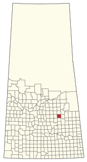
The Rural Municipality of Sasman No. 336 is a rural municipality (RM) in the Canadian province of Saskatchewan within Census Division No. 10 and SARM Division No. 4.

