
Regina International Airport is an international airport located in Regina, Saskatchewan, Canada, located 2 nautical miles south-west and 7 km (4.3 mi) west-southwest of the city centre. It is run by the Regina Airport Authority. In 2022, it was the 16th busiest airport in Canada.

La Ronge is a northern town in the boreal forest of central Saskatchewan, Canada. Its location is approximately 250 km (160 mi) north of Prince Albert where Highway 2 becomes Highway 102. La Ronge lies on the western shore of Lac la Ronge, is adjacent to Lac La Ronge Provincial Park, and is on the edge of the Canadian Shield.

Sept-Îles Airport is situated 4.5 nautical miles east of the town of Sept-Îles, Quebec, Canada.
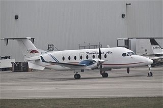
Rise Air is a scheduled and charter airline primarily serving the Canadian province of Saskatchewan. Its headquarters and main base was at Prince Albert.
Buffalo Narrows Airport is located 2 NM east-southeast of Buffalo Narrows, Saskatchewan, Canada.

Coronach/Scobey Border Station Airport is located 8 nautical miles southeast of Coronach, Saskatchewan, Canada and 13 mi (21 km) north of Scobey, Montana, United States. In the United States, the airport is known by the names Scobey Border Station Airport and East Poplar International Airport. It is owned by the U.S. and Canadian governments.
Estevan Regional Aerodrome is an aerodrome located 3 nautical miles north of Estevan, Saskatchewan, Canada.

Lloydminster Airport is located 2 nautical miles northwest of Lloydminster, Alberta, Canada.
Key Lake Airport is a regional airport near the Key Lake mine in Saskatchewan, Canada.
Kindersley Regional Airport is located 2.5 nautical miles north of Kindersley, Saskatchewan, Canada.
La Ronge Water Aerodrome is located adjacent to La Ronge, Saskatchewan, Canada.
Meadow Lake Airport is located 2 nautical miles west of Meadow Lake, Saskatchewan, Canada.
Nipawin Airport is located 1.3 nautical miles south of Nipawin, Saskatchewan, Canada.

North Battleford Airport is located 1.5 nautical miles east of North Battleford, Saskatchewan, Canada.

Prince Albert Airport is located 1 nautical mile northeast of Prince Albert, Saskatchewan, Canada.

Stony Rapids Airport is located adjacent to Stony Rapids, Saskatchewan, Canada.
Yorkton Municipal Airport is located 2.8 nautical miles north of Yorkton, Saskatchewan, Canada.

Wollaston Lake is a lake in north-eastern part of the Canadian province of Saskatchewan. It is about 550 kilometres (340 mi) north-east of Prince Albert. With a surface area of 2,286 square kilometres (883 sq mi), it is the largest bifurcation lake in the world – that is, a lake that drains naturally in two directions.


