Lake Chaffee, Connecticut | |
---|---|
Coordinates: 41°56′19″N72°11′45″W / 41.93861°N 72.19583°W Coordinates: 41°56′19″N72°11′45″W / 41.93861°N 72.19583°W | |
Country | United States |
State | Connecticut |
County | Windham |
Town | Ashford |
Area | |
• Total | 0.55 km2 (0.21 sq mi) |
• Land | 0.34 km2 (0.13 sq mi) |
• Water | 0.21 km2 (0.08 sq mi) |
Elevation | 261 m (856 ft) |
Time zone | UTC-5 (Eastern (EST)) |
• Summer (DST) | UTC-4 (EDT) |
ZIP Code | 06278 (Ashford) |
Area code(s) | 860/959 |
FIPS code | 09-41238 |
GNIS feature ID | 2805991 [2] |
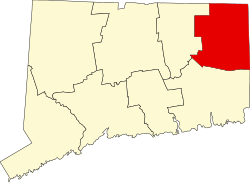
Lake Chaffee is a census-designated place (CDP) in the northwest part of the town of Ashford, Windham County, Connecticut, United States. It is a residential community surrounding Lake Chaffee, a small water body formed in the early 20th century by damming an area of wetlands. Connecticut Route 89 (Ference Road) forms the eastern edge of the CDP, leading north 1.5 miles (2.4 km) to Interstate 84 and south 6 miles (10 km) to U.S. Route 44 at Warrenville.
Lake Chaffee was first listed as a CDP prior to the 2020 census.
Terramuggus is a census-designated place (CDP) in the town of Marlborough, Hartford County, Connecticut, United States. It contains the town center village and surrounding areas. The population was 1,025 at the 2010 census.
Northwest Harwinton is a census-designated place (CDP) in the town of Harwinton in Litchfield County, Connecticut, United States. The population was 3,252 at the 2010 census, out of 5,642 in the entire town. The CDP contains the town center.
Oakville is a census-designated place (CDP) and neighborhood section of Watertown, in Litchfield County, Connecticut, United States. The population was 9,047 as of the 2010 census. It is the most populous community in Watertown, with more than twice as many people as the center village of Watertown. The ZIP code for Oakville is 06779.
Gages Lake is a census-designated place (CDP) in Warren Township, Lake County, Illinois, United States. The population was 10,198 at the 2010 census.
Grandwood Park is a census-designated place (CDP) in Warren Township, Lake County, Illinois, United States. The population was 5,202 at the 2010 census.
Harbor Hills is a census-designated place (CDP) in Licking County, Ohio, United States. The population was 1,509 at the 2010 census, up from 1,303 at the 2000 census. It includes the unincorporated communities of Harbor Hills and Edgewater Beach.
Johnson Village is an unincorporated community and a census-designated place (CDP) located in and governed by Chaffee County, Colorado, United States. The population of the Johnson Village CDP was 246 at the United States Census 2010. The Buena Vista post office serves the area.
Lakeville is a census-designated place (CDP) in Litchfield County, Connecticut, United States, close to Dutchess County, New York. It is within the town of Salisbury but has its own ZIP Code (06039). As of the 2010 census, the population of Lakeville was 928, out of 3,741 in the entire town of Salisbury.
Buttzville is an unincorporated community and census-designated place (CDP) located within White Township in Warren County, New Jersey, United States, that was created as part of the 2010 United States Census. As of the 2010 Census, the CDP's population was 146.
Lakeville is a hamlet and census-designated place (CDP) in the town of Livonia, Livingston County, New York, United States. Its population was 756 as of the 2010 census.
Falls Village is a village and census-designated place in the town of Canaan in Litchfield County, Connecticut, United States. As of the 2010 census it had a population of 538, out of 1,234 in the entire town of Canaan. Because Falls Village is the town center and principal constituent village in Canaan, the entire town is often referred to as "Falls Village". That usage also avoids confusion of the town with Canaan Village in the town of North Canaan, Connecticut, not far away. Falls Village derives its name from a waterfall, known as Great Falls, on the Housatonic River within the village.
New Hartford Center is a census-designated place (CDP) in Litchfield County, Connecticut, United States. It comprises the village of New Hartford, the adjacent Pine Meadow Historic District, and some surrounding forest land, all within the town of New Hartford. As of the 2010 census, the population of New Hartford Center was 1,385, out of 6,970 in the entire town of New Hartford.
Wilton Center is a neighborhood/section and census-designated place (CDP) in the town of Wilton in Fairfield County, Connecticut, United States. As of the 2010 census it had a population of 732. The CDP partially overlaps the Wilton Center Historic District.
Windsor is a census-designated place (CDP) comprising the main settlement within the town of Windsor, Windsor County, Vermont, United States. The population of the CDP was 2,066 at the 2010 census, compared with 3,553 for the town as a whole.
Newcastle is a census-designated place (CDP) comprising the main village of the town of Newcastle in Lincoln County, Maine, United States. The population was 667 at the 2010 census, out of 1,752 in the entire town. In the 2000 census, the village was part of the Damariscotta-Newcastle CDP.
Indian Mountain Lake is a census-designated place (CDP) in Carbon County and Monroe County, Pennsylvania, United States. The Carbon County portion of the CDP is in Penn Forest Township, while the Monroe County portion is in Tunkhannock and Chestnuthill townships. As of the 2010 census, the population of the community was 4,372. There are 3,262 single-family residential building lots in the community.
Machias is a hamlet and census-designated place (CDP) in the northeast part of the town of Machias, in Cattaraugus County, New York, United States. As of the 2010 census, it had a population of 471. Prior to the 2010 census, the area was delineated as part of the Lime Lake-Machias CDP.
Springwater is a hamlet and census-designated place in the town of Springwater, Livingston County, New York, United States. Its population was 549 as of the 2010 census. New York State Routes 15 and 15A intersect in the community.
Weston is a census-designated place (CDP) in the town of Weston, Fairfield County, Connecticut, United States. It comprises the center of town government and surrounding residential areas. The area was known as "Norfield" from 1795 to 1920, and the Norfield Historic District, which occupies the center of the CDP, around the intersection of Norfield Road and Weston Road, preserves the older name.
Kellogg Point is a census-designated place (CDP) in the town of New Fairfield, Fairfield County, Connecticut, United States. It is in the southeast part of the town, on the western shore of Candlewood Lake. It is 6 miles (10 km) north of the center of Danbury, Connecticut.