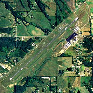
Barnstable Municipal Airport, also known as Boardman/Polando Field, is a public airport located on Cape Cod, one mile (1.6 km) north of the central business district of Hyannis, in Barnstable County, Massachusetts, United States. This airport is publicly owned by Town of Barnstable. It is Cape Cod's major airport as well as an air hub for the Cape and the Islands. The airport is served by scheduled commercial flights as well as charters and general aviation. Barnstable Municipal Airport served as a hub for Nantucket-based commuter airline Island Airlines until its shutdown in 2015.

Provincetown Municipal Airport is a public airport located at the end of Cape Cod, two miles (3 km) northwest of the central business district of Provincetown, in Barnstable County, Massachusetts, United States. This airport is operated by the Town of Provincetown on land leased from the U.S. National Park Service.
Taunton Municipal Airport, also known as King Field, is a public use airport located three nautical miles (6 km) east of the central business district of Taunton, a city in Bristol County, Massachusetts, United States. It is located in the East Taunton neighborhood of the city. The city-owned airport is maintained and operated by the Taunton Airport Commission. According to the FAA's National Plan of Integrated Airport Systems for 2009–2013, it is categorized as a general aviation airport.
Metropolitan Airport was a privately owned, private-use airport located in the town of Palmer, in Hampden County, Massachusetts, USA. It has one runway, averaged 22 flights per day, and had approximately 24 aircraft based on its field.

Wakulla County Airport is a county-owned, public-use airport in Wakulla County, Florida, United States. It is located three nautical miles (6 km) south of the central business district of Panacea, Florida.
Merrimack Valley Seaplane Base is a privately owned, public-use seaplane base located three miles (5 km) west of the central business district of Methuen, a city in Essex County, Massachusetts, United States.
Monponsett Pond Seaplane Base is a privately owned, public-use seaplane base located two miles (3 km) northwest of the central business district of Halifax, a town in Plymouth County, Massachusetts, United States.

Beaver County Airport or is a county-owned public airport three miles northwest of Beaver Falls, in Beaver County, Pennsylvania.

Albertville Regional Airport, also known as Thomas J. Brumlik Field, is a city-owned, public-use airport located three nautical miles southwest of the central business district of Albertville, in Marshall County, Alabama, United States. It was formerly known as Albertville Municipal Airport.

Atmore Municipal Airport is a city-owned public-use airport located 3 nautical miles (6 km) east of the central business district of Atmore, a city in Escambia County, Alabama, United States. According to the FAA's National Plan of Integrated Airport Systems for 2009–2013, it is categorized as a general aviation facility.

Butler–Choctaw County Airport is a city-owned public-use airport located 5 nautical miles (9 km) northeast of the central business district of Butler, a city in Choctaw County, Alabama, United States. According to the FAA's National Plan of Integrated Airport Systems for 2009–2013, it is categorized as a general aviation facility.

Bibb County Airport is a county-owned public-use airport in Bibb County, Alabama, United States. It is located 3 nautical miles (6 km) east of the central business district of Brent, Alabama. According to the FAA's National Plan of Integrated Airport Systems for 2009–2013, it is categorized as a general aviation facility.

Headland Municipal Airport is a city-owned, public-use airport located two nautical miles northeast of the central business district of Headland, a city in Henry County, Alabama, United States.

Camp Edwards Heliport is a private use heliport located at Camp Edwards, a U.S. Army facility in Barnstable County, Massachusetts, United States. The airport is located three nautical miles (6 km) north of the central business district of Bourne, Massachusetts. It is owned by the Massachusetts Army National Guard.

Flabob Airport is a small public-use airport located three nautical miles (6 km) northwest of the central business district of Riverside, in Riverside County, California, United States.
Snow Airport is a privately owned, private-use airport located in the town of Ipswich, in Essex County, Massachusetts, USA. It has one runway, 4/22.
Ware Airport is a privately owned, private-use airport located in the town of Ware, in Worcester County, Massachusetts, USA. It has one runway, N/S.
Muskeget Island Airport is a small airport located on Muskeget Island in the town of Nantucket. It is unclear why Muskeget is listed as an airport, as clearly there is no airport located anywhere on the island. The only known occurrence of an aircraft landing on Muskeget was a Piper J-3 Cub in 1949 that touched down on a beach.
Tuckernuck Island Airport is a small, unpaved airstrip located on Tuckernuck Island in the town of Nantucket. It is privately owned and currently has one aircraft, a Cessna 185, based there. It has one runway. The south end of the runway meets the water of the north Atlantic Ocean, while the north end meets the islands forests and grasslands. There is one shed on the east side. The runway length is decreasing due to sea level rise and beach erosion, attributable to climate change. Length 600 ft in 2019.
Canapitsit Airport is a private airfield operational in Gosnold, Massachusetts.


