Related Research Articles
Taunton Municipal Airport, also known as King Field, is a public use airport located three nautical miles (6 km) east of the central business district of Taunton, a city in Bristol County, Massachusetts, United States. It is located in the East Taunton neighborhood of the city. The city-owned airport is maintained and operated by the Taunton Airport Commission. According to the FAA's National Plan of Integrated Airport Systems for 2009–2013, it is categorized as a general aviation airport.
Metropolitan Airport was a privately owned, private-use airport located in the town of Palmer, in Hampden County, Massachusetts, USA. It has one runway, averaged 22 flights per day, and had approximately 24 aircraft based on its field.

Plymouth Municipal Airport is a town-owned, public-use airport located four nautical miles (7 km) southwest of the central business district of Plymouth, a town in Plymouth County, Massachusetts, United States. According to the FAA's National Plan of Integrated Airport Systems for 2009–2013, it is categorized as a general aviation airport. Due to space issues, the airport has 2 gates in Carver, Massachusetts.
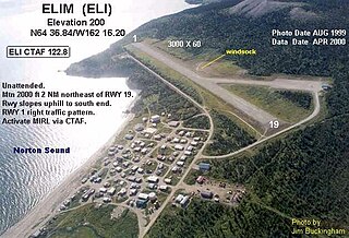
Elim Airport is a state-owned, public-use airport located three nautical miles (6 km) southwest of the central business district of Elim, a city in the Nome Census Area of the U.S. state of Alaska.
South Jersey Regional Airport is a public use airport in Lumberton Township, Burlington County, New Jersey, United States. Owned by the New Jersey Department of Transportation, the airport is located four nautical miles southwest of the central business district of Mount Holly, New Jersey. This facility is included in the National Plan of Integrated Airport Systems for 2011–2015, which categorized it as a general aviation reliever airport.
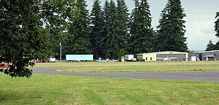
Scappoose Airport is a public use airport located one nautical mile (1.85 km) northeast of the central business district of Scappoose, in Columbia County, Oregon, United States. It is owned and operated by the Port of Columbia County, an Oregon port district and municipal corporation, on behalf of district residents. According to the FAA's National Plan of Integrated Airport Systems for 2009–2013, it is categorized as a general aviation airport.

Skyport Airport is a public use airport located three nautical miles north of the central business district of Cornelius, a city in Washington County, Oregon, United States. It is privately owned and managed by V. D. Putman.
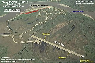
Allakaket Airport, is a state-owned public-use airport located two nautical miles (4 km) north-northwest of the central business district of Allakaket, a city in the Yukon-Koyukuk Census Area of the U.S. state of Alaska. The airport is sometimes referred to as the New Allakaket Airport because it was constructed on a site southeast of the original airport which is now closed.
Beluga Airport is a private use airport in Beluga, in the Kenai Peninsula Borough of the U.S. state of Alaska. It is privately owned by ConocoPhillips.
Pittsburgh Northeast Airport is a privately owned, public use airport in Allegheny County, Pennsylvania, United States. The airport is located 12 nautical miles north-northeast of the central business district of Pittsburgh, in West Deer Township. The airport is located a few miles north of Pittsburgh Mills shopping mall.

Grove Hill Municipal Airport was a city-owned public-use airport located two nautical miles southeast of the central business district of Grove Hill, a city in Clarke County, Alabama, United States. According to the FAA's National Plan of Integrated Airport Systems for 2009–2013, it was categorized as a general aviation facility. The airport has been permanently closed.
Tok Junction Airport is a state-owned public-use airport located one nautical mile east of the central business district of Tok, in the Southeast Fairbanks Census Area of the U.S. state of Alaska.
Camp Edwards Heliport is a private use heliport located at Camp Edwards, a U.S. Army facility in Barnstable County, Massachusetts, United States. The airport is located three nautical miles (6 km) north of the central business district of Bourne, Massachusetts. It is owned by the Massachusetts Army National Guard.
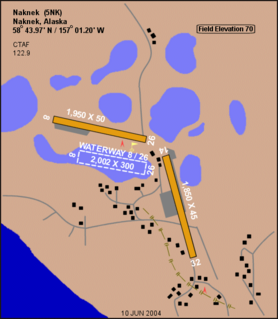
Naknek Airport is a state-owned, public-use airport located one nautical mile north of the central business district of Naknek, in the Bristol Bay Borough of the U.S. state of Alaska.

Port Alsworth Airport is a private-use airport serving Port Alsworth which is located in the Lake and Peninsula Borough of the U.S. state of Alaska. As per Federal Aviation Administration records, the airport had 2,634 passenger boardings (enplanements) in calendar year 2019, an increase of 52.87% from the 1,723 enplanements in 2018.
Skwentna Airport is a state-owned public-use airport located in Skwentna, in the Matanuska-Susitna Borough of the U.S. state of Alaska.
Saginaw Seaplane Base is a privately owned public-use seaplane base located at Saginaw Bay, Alaska. As per Federal Aviation Administration records, the airport had 418 passenger boardings (enplanements) in calendar year 2010, an increase of 27% from the 330 enplanements in 2009.
Ranchaero Airport is a private-use airport a mile west of Chico, in Butte County, California.
Greensburg Jeannette Regional Airport is a privately owned, public use airport located three nautical miles (6 km) north of the central business district of Jeannette, a city in Westmoreland County, Pennsylvania, United States. This airport was included in the National Plan of Integrated Airport Systems for 2009–2013, which categorized it as a general aviation facility.
Snow Airport is a privately owned, private-use airport located in the town of Ipswich, in Essex County, Massachusetts, USA. It has one runway, 4/22.