Taupō, sometimes spelled Taupo, is a town on the north-eastern shore of Lake Taupo in the central North Island of New Zealand. The town is the largest urban area and the seat of the Taupo District, and the second-largest urban area in the Waikato region behind Hamilton.

The University of Waikato, is a comprehensive university. The university's main campus is in Hamilton, New Zealand and was established in 1964. An additional campus is located in Tauranga. The university provides a strong, research-led global contribution in the disciplines of education, social sciences, and management and is an innovator in environmental science, marine and freshwater ecology, engineering and computer science. It offers degrees in Health, Engineering, computer science, management, Māori and Indigenous Studies, the Arts, Psychology, Social Sciences and Education.

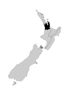
Waikato is a local government region of the upper North Island of New Zealand. It covers the Waikato District, Waipa District, Matamata-Piako District, South Waikato District and Hamilton City, as well as Hauraki, Coromandel Peninsula, the northern King Country, much of the Taupō District, and parts of Rotorua District. It is governed by the Waikato Regional Council.

The Waikato River is the longest river in New Zealand, running for 425 kilometres (264 mi) through the North Island. It rises in the eastern slopes of Mount Ruapehu, joining the Tongariro River system and flowing through Lake Taupo, New Zealand's largest lake. It then drains Taupo at the lake's northeastern edge, creates the Huka Falls, and flows northwest through the Waikato Plains. It empties into the Tasman Sea south of Auckland, at Port Waikato. It gives its name to the Waikato region that surrounds the Waikato Plains. The present course of the river was largely formed about 17,000 years ago. Contributing factors were climate warming, forest being reestablished in the river headwaters and the deepening, rather than widening, of the existing river channel. The channel was gradually eroded as far up river as Piarere, leaving the old Hinuera channel through the Hinuera Gap high and dry. The remains of the old river path can be clearly seen at Hinuera where the cliffs mark the ancient river edges. The river's main tributary is the Waipa River, which has its confluence with the Waikato at Ngāruawāhia.
Cambridge is a town in the Waipa District of the Waikato region of the North Island of New Zealand. Situated 24 kilometres (15 mi) southeast of Hamilton, on the banks of the Waikato River, Cambridge is known as "The Town of Trees & Champions". The town has a population of 20,500, making it the largest town in the Waipa District, and the third largest urban area in the Waikato.

Huntly is a town in the Waikato district and region of the North Island of New Zealand. It is on State Highway 1, 95 kilometres (59 mi) south of Auckland and 32 kilometres (20 mi) north of Hamilton. It is situated on the North Island Main Trunk (NIMT) railway and straddles the Waikato River. Huntly is within the Waikato District which is in the northern part of the Waikato region local government area.

Waikato District is a territorial authority of New Zealand, in the northern part of Waikato region, North Island. Waikato District is administered by the Waikato District Council, with headquarters in Ngāruawāhia.

Lake Tikitapu, more commonly known as Blue Lake, is the smallest of four small lakes lying between Lake Rotorua and Lake Tarawera in the Bay of Plenty region of New Zealand's North Island. The other three are Lake Rotokakahi, Lake Okareka, and Lake Okataina.

Mount Pirongia is an extinct stratovolcano located in the Waikato region of New Zealand's North Island. It rises to 959 metres and is the highest peak in the Waikato region. It was active in the late Pliocene and early Pleistocene times. Pirongia's many peaks are basaltic cones created by successive volcanic eruptions about 2.5 million years ago. In the adjacent picture, the characteristic profile of the mountain can be seen, along with a prominent accessory cone to the right.

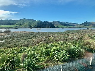
The Waikato Plains form a large area of low-lying land in the northwest of the North Island of New Zealand. They are the alluvial plains of the ancient Waikato River, the country's longest river that over the last 1800 years has changed course many times. In the distant past the river flowed northeast from the current Lake Karapiro, exiting near Thames, but in recent times it has flowed northwest to empty into the Tasman Sea near Port Waikato.

The Waiau River is the largest river in the Southland region of New Zealand. 'Waiau' translates to 'River of Swirling Currents'. It is the outflow of Lake Te Anau, flowing from it into Lake Manapouri 10 kilometres (6 mi) to the south, and from there flows south for 70 kilometres (43 mi) before reaching the Foveaux Strait 8 kilometres (5 mi) south of Tuatapere. It also takes water from Lake Monowai.
Rotowaro was once a small coal mining township approximately 10 km west of Huntly in the Waikato region of New Zealand. The town was built especially for miners houses, but was entirely removed in the 1980s to make way for a large opencast mine.

Lake Rotoroa is a lake in Hamilton, Waikato, North Island, New Zealand. It has a surface area of about 54 hectares and an average depth of 2.4 metres. It is the home of the Hamilton Yacht Club, which holds regular sailing in the summer.
Hauraki-Waikato is a New Zealand parliamentary Māori electorate first established for the 2008 election. It largely replaced the Tainui electorate. Nanaia Mahuta of the Labour Party, formerly the MP for Tainui, became MP for Hauraki-Waikato in the 2008 general election and was re-elected in 2011, 2014, 2017 and 2020.
The Whangamarino River is a lowland river of the Waikato Region of New Zealand's North Island, draining the Whangamarino Wetland and associated farmland catchment. The river converges with the Waikato River just north of Meremere. The main tributary is the Maramarua River, which starts in the Hunua Ranges and forms the northern catchment of the Whangamarino River.

The Waikato River Trails is a combined walk- and cycleway along the Waikato River. Originally conceived and started by local politicians and trustees, in 2009 the trails became one of the seven Quick Start Projects that form the beginning of the New Zealand Cycle Trail. The trail is proposed to be 100 km long, out of which 50 km existed before the NZCT scheme was created. In mid-2011, work on the last sections of the cycle trail project sections was begun, while the official grand opening occurred early November 2011.
Lake Kimihia is located approximately 5 km to the Northeast of Huntly, in the Waikato Region of New Zealand. Lake Kimihia is a riverine lake, which links to the Waikato River.

Lake Waahi is located immediately to the west of Huntly, in the Waikato Region. Lake Waahi is a riverine lake, which links to the Waikato River by way of the short Waahi Stream. The smaller Lake Puketirini lies immediately to Waahi's southeast.

Lake Rotongaro is located to the west of Ohinewai in the Waikato Region of New Zealand. It is a large shallow riverine lake, which links to the Waikato River. It is situated between the Waikato River and the larger Lake Whangape.