Lancaster Township, Jefferson County, Indiana

Last updated

Lancaster Township
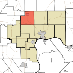
Map highlighting Lancaster Township, Jefferson County, Indiana.svg
Location in Jefferson County
Coordinates: 38°52′07″N85°30′28″W / 38.86861°N 85.50778°W / 38.86861; -85.50778
CountryUnited States
State Indiana
County Jefferson
Government
  Type Indiana township
Area
  Total
32.23 sq mi (83.5 km2)
  Land32.18 sq mi (83.3 km2)
  Water0.05 sq mi (0.13 km2)  0.16%
Elevation
794 ft (242 m)
Population
 (2020)
  Total
1,494
  Density46.43/sq mi (17.93/km2)
GNIS feature ID0453539

Lancaster Township is one of ten townships in Jefferson County, Indiana, United States. As of the 2020 census, its population was 1,494 (down from 1,511 at 2010 [1] ) and it contained 610 housing units. [2]

Contents

Historical population
CensusPop.Note
1890 1,272
1900 1,2790.6%
1910 1,229−3.9%
1920 1,160−5.6%
1930 953−17.8%
1940 9863.5%
1950 1,12414.0%
1960 1,2309.4%
1970 1,3459.3%
1980 1,48410.3%
1990 1,5343.4%
2000 1,6084.8%
2010 1,511−6.0%
2020 1,494−1.1%
Source: US Decennial Census [3]

History

Eleutherian College and the Lyman and Asenath Hoyt House are listed on the National Register of Historic Places. [4]

Geography

According to the 2010 census, the township has a total area of 32.23 square miles (83.5 km2), of which 32.18 square miles (83.3 km2) (or 99.84%) is land and 0.05 square miles (0.13 km2) (or 0.16%) is water. [1] The streams of Middle Fork Creek and Turkey Branch run through this township.

Cities and towns

Unincorporated towns

Extinct towns

Adjacent townships

Cemeteries

The township contains five cemeteries: Bland, Clashman, College Hill, Nelson and Ogden.

Major highways

Education

It is in the Madison Consolidated Schools school district. [5]

The zoned MCS elementary school for part of the township is Anderson Elementary School, while another part is zoned to Deputy Elementary School. [6] The zoned secondary schools of the Madison district are Madison Junior High School and Madison Consolidated High School.

References

  1. 1 2 "Population, Housing Units, Area, and Density: 2010 - County -- County Subdivision and Place -- 2010 Census Summary File 1". United States Census. Retrieved May 10, 2013.{{cite web}}: CS1 maint: deprecated archival service (link)
  2. "Explore Census Data". data.census.gov. Retrieved April 10, 2024.
  3. "Township Census Counts: STATS Indiana".
  4. "National Register Information System". National Register of Historic Places . National Park Service. July 9, 2010.
  5. Geography Division (December 18, 2020). 2020 Census - School District Reference Map: Jefferson County, IN (PDF) (Map). Suitland, Maryland: U.S. Census Bureau . Retrieved February 7, 2026. - Text list
  6. "Elementary School District Map". Madison Consolidated Schools . Retrieved February 7, 2026.