Davis County is a county in northern Utah, United States. As of the 2010 United States Census, the population was 306,479, making it Utah's third-most populous county. Its county seat is Farmington, and its largest city is Layton.
Morgan County is a county in northern Utah, United States. As of the 2010 census, the population was 9,469. Its county seat and largest city is Morgan. Morgan County is part of the Ogden-Clearfield, UT Metropolitan Statistical Area as well as the Salt Lake City-Provo-Orem, UT Combined Statistical Area.

Weber County is a county in the U.S. state of Utah. As of the 2010 census, the population was 231,236, making it Utah's fourth-most populous county. Its county seat and largest city is Ogden, the home of Weber State University. The county was named for the Weber River.

Avon is a census-designated place (CDP) in Cache County, Utah, United States. The population was 367 at the 2010 census. It is included in the Logan, Utah-Idaho (partial) Metropolitan Statistical Area.

Cottonwood Heights is a city located in Salt Lake County, Utah, United States, along the east bench of the Salt Lake Valley. It lies south of the cities of Holladay and Murray, east of Midvale, and north of Sandy within the Salt Lake City, Utah Metropolitan Statistical Area. Following a successful incorporation referendum in May 2004, the city was incorporated on January 14, 2005. Cottonwood Heights had been a Census-designated place (CDP) before incorporation. The population as of the 2010 census was 33,433. This is a significant increase over the CDP's 2000 census count of 27,569.

Hooper is a city in Weber County, Utah, United States, first called Muskrat Springs and later Hooperville for Captain William Henry Hooper, an early Utah delegate to Congress. The population was 6,932 at the 2010 census, up from the 2000 figure of 3,926. Prior to the city's incorporation on November 30, 2000, Hooper was an unincorporated census-designated place (CDP).

Huntsville is a town in Weber County, Utah, United States. The population was 608 at the 2010 census. It is located in Ogden Valley. It is part of the Ogden–Clearfield, Utah Metropolitan Statistical Area.
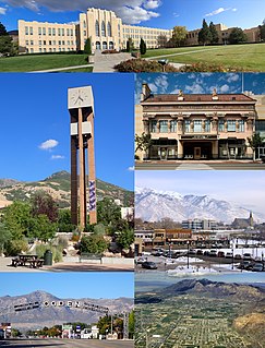
Ogden is a city and the county seat of Weber County, Utah, United States, approximately 10 miles (16 km) east of the Great Salt Lake and 40 miles (64 km) north of Salt Lake City. The population was 87,773 in 2019, according to the US Census Bureau, making it Utah's 7th largest city. The city served as a major railway hub through much of its history, and still handles a great deal of freight rail traffic which makes it a convenient location for manufacturing and commerce. Ogden is also known for its many historic buildings, proximity to the Wasatch Mountains, and as the location of Weber State University.

The Wasatch Front is a metropolitan region in the north-central part of the U.S. state of Utah. It consists of a chain of contiguous cities and towns stretched along the Wasatch Range from approximately Nephi in the south to Brigham City in the north. Roughly 80% of Utah's population resides in this region, which contains the major cities of Salt Lake City, West Valley City, Provo, West Jordan, Layton, and Ogden.

Weber High School is a Utah secondary school located in Pleasant View, Utah, about five miles north of Ogden. It serves the residents of Pleasant View, North Ogden, Harrisville, Huntsville, Eden, and Liberty. It is part of the Weber School District and includes grades 10–12.

Nordic Valley is an unincorporated community in Weber County, Utah, United States. It is part of the Ogden–Clearfield, Utah Metropolitan Statistical Area.
The Weber County Library System (WCLS) is a public library system in northern Utah, United States. The WCLS serves a population of approximately 213,000 Weber County residents, with interlocal agreements, extending access to 330,000 residents in surrounding counties. The WCLS consists of a main library in Ogden, and four branches located in Roy, North Ogden, Huntsville, and Washington Terrace.

Sutherland is a census-designated place in northeastern Millard County, Utah, United States. The population was 165 at the 2010 census.

Eden is a census-designated place in Weber County, Utah, United States. It is home to Powder Mountain ski resort. It lies between the North and Middle Fork of the Ogden River, north of Pineview Reservoir, in Ogden Valley. The elevation is 4,941 feet (1,506 m). The population was 600 at the 2010 census. Although it is unincorporated, it has a post office, with the ZIP code of 84310. Eden is part of the Ogden–Clearfield, Utah Metropolitan Statistical Area.

Mountain Green is a census-designated place in northwestern Morgan County, Utah, United States. The population was 2,309 at the 2010 census. Located 16 miles (26 km) up the Weber River from Ogden, Mountain Green is the world headquarters of the Browning Arms Company.

Spring Glen is a census-designated place in Carbon County, in eastern Utah, United States. The population was 1,126 at the 2010 census. Founded in 1878, Spring Glen was the first permanent settlement in what is now Carbon County. First settled principally by white Mormon farmers, the community became much more diverse after about 1890, when the development of the area's coal mines brought an influx of immigrants from Southern Europe and other regions.
Utah State Route 158 is a state highway in the U.S. state of Utah. Spanning 11.6 miles (18.7 km), it connects Powder Mountain Ski Resort and the towns of Liberty and Eden with Utah State Route 39 in Ogden Canyon in Weber County. A portion of the road is designated as part of the Ogden River Scenic Byway.

Marion is a census-designated place in Summit County, Utah, United States. The population was 685, according to the 2010 census.
KWCS-TV, UHF analog channel 18, was a non-commercial educational television station licensed to Ogden, Utah, United States, which broadcast from 1960 until the early 1970s. Owned by Weber County Schools, the station broadcast instructional programming for students in the county's elementary and junior high schools. It also broadcast evening programming from National Educational Television (NET). KWCS-TV itself disappeared after being merged with KOET, the station operated by the Ogden City Board of Education; Weber County pulled out of the partnership in 1973, a move which also prompted the closure of the Ogden school board's station.

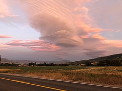
Ogden Valley is a high mountain valley in Weber County, Utah, United States. The population was 6,855 at the 2010 census. Planning in the valley is managed by a special county-level planning division, the Ogden Valley Planning Commission. The valley is a popular vacation and tourism destination with three ski resorts, Pineview Reservoir, Causey Reservoir, and national forest lands.