Libo County

Last updated • 3 min readFrom Wikipedia, The Free Encyclopedia
Libo County
荔波县
Lipo
Xiaoqikong.JPG
Administrative Division Qiannan.png
Libo is the southeasternmost division in this map of Qiannan
Location of Qiannan Prefecture within Guizhou (China).png
Qiannan in Guizhou
China Guizhou location map.jpg
Red pog.svg
Libo
Location of the seat in Guizhou
China Southwest adm location map.svg
Red pog.svg
Libo
Libo (Southwest China)
Coordinates(Libo County government): 25°25′26″N107°53′56″E / 25.4238°N 107.8988°E / 25.4238; 107.8988
Country China
Province Guizhou
Autonomous prefecture Qiannan
County seatYuping
Area
  Total2,432 km2 (939 sq mi)
Population
 (2010)
  Total144,849
  Density60/km2 (150/sq mi)
Time zone UTC+8 (China Standard)
Postal code
558400
Area code 0584
Website http://www.libo.gov.cn/

Libo County (simplified Chinese :荔波县; traditional Chinese :荔波縣; pinyin :Lìbō Xiàn) is a county of southern Guizhou province, China, bordering Guangxi to the south. It is under the administration of the Qiannan Buyei and Miao Autonomous Prefecture.

Contents

Geography

The county is located in the remote southeastern corner of the prefecture, on the border with Guangxi. Two local sites, Xiaoqikong (小七孔) and Dongduo (洞多), notable for their spectacular karst formations, form part of the multi-site South China Karst UNESCO World Heritage Site inscribed in 2007, which is an area about 550,000 km2 in extent. [1]

Administrative divisions

Libo County is divided into 1 subdistrict, 5 towns and 2 ethnic township: [2]

subdistrict
towns
ethnic townships

Languages

Southwestern Mandarin, Mak, Ai-Cham, Bouyei, Sui, and Numao are spoken in Libo County. Sui is spoken primarily in Shuiyao Shui Ethnic Township 水尧水族乡. [3]

Transportation

The Qiannan Libo Airport, opened in late 2007, has capacity to receive planes of the Boeing 737 class, and to handle up to 220,000 passengers annually. [4] However, the $57-million facility is rather underutilized so far. [4] According to the Civil Aviation Administration of China (CAAC) statistics, 151 paying passengers flew into or out of the airport in 2009 - which was a 98% drop compared to the previous year (7886 passengers), and placed the airport the last in list of the nation's 166 airports by traffic volume. [5] Currently four airlines use the airport.

Flora

The karst environments in Libo County consist of the following types of forests. [1]

Common angiosperm genera include Beilschmiedia , Cryptocarya , Casearia , Diospyros , Pittosporum , Acer , Carpinus , Ulmus , Viburnum , Prunus , and Rosa . Protected wild plants in Libo County include Handeliodendron bodinieri , Mussaenda anomala , Taxus chinensis , Paphiopedilum emersonii , Paphiopedilum barbigerum and Paphiopedilum micranthum , Pinus kwangtungensis , Pseudotsuga sinensis , Pseudotsuga brevifolia , Calocedrus macrolepis , Tetrathyrium subcordatum , Trachycarpus nana , Emmenopterys henryi , Liriodendron chinense . [1]

Climate

Climate data for Libo (1991–2020 normals, extremes 1981–2010)
MonthJanFebMarAprMayJunJulAugSepOctNovDecYear
Record high °C (°F)26.2
(79.2)
32.3
(90.1)
34.4
(93.9)
35.8
(96.4)
36.1
(97.0)
36.5
(97.7)
37.9
(100.2)
39.2
(102.6)
37.3
(99.1)
35.6
(96.1)
31.3
(88.3)
29.2
(84.6)
39.2
(102.6)
Mean daily maximum °C (°F)12.4
(54.3)
15.5
(59.9)
19.1
(66.4)
24.6
(76.3)
28.2
(82.8)
30.1
(86.2)
31.8
(89.2)
32.3
(90.1)
30.0
(86.0)
25.3
(77.5)
20.9
(69.6)
15.5
(59.9)
23.8
(74.9)
Daily mean °C (°F)8.6
(47.5)
11.1
(52.0)
14.6
(58.3)
19.6
(67.3)
23.2
(73.8)
25.5
(77.9)
26.7
(80.1)
26.4
(79.5)
24.1
(75.4)
19.9
(67.8)
15.4
(59.7)
10.6
(51.1)
18.8
(65.9)
Mean daily minimum °C (°F)6.1
(43.0)
8.2
(46.8)
11.6
(52.9)
16.1
(61.0)
19.6
(67.3)
22.5
(72.5)
23.5
(74.3)
22.8
(73.0)
20.3
(68.5)
16.5
(61.7)
11.8
(53.2)
7.4
(45.3)
15.5
(60.0)
Record low °C (°F)−4.3
(24.3)
−1.9
(28.6)
0.0
(32.0)
3.8
(38.8)
7.9
(46.2)
12.5
(54.5)
15.7
(60.3)
17.5
(63.5)
11.8
(53.2)
5.3
(41.5)
−0.1
(31.8)
−4.0
(24.8)
−4.3
(24.3)
Average precipitation mm (inches)27.4
(1.08)
30.0
(1.18)
53.4
(2.10)
94.2
(3.71)
167.9
(6.61)
262.0
(10.31)
218.1
(8.59)
176.2
(6.94)
94.7
(3.73)
65.9
(2.59)
38.5
(1.52)
22.0
(0.87)
1,250.3
(49.23)
Average precipitation days (≥ 0.1 mm)10.09.013.714.616.718.618.215.010.29.98.57.3151.7
Average snowy days1.20.40000000000.31.9
Average relative humidity (%)74737676788282807776757177
Mean monthly sunshine hours 37.543.054.577.793.881.4132.5159.9141.4103.391.874.11,090.9
Percent possible sunshine 11131520222032403929282324
Source: China Meteorological Administration [6] [7]

Related Research Articles

<span class="mw-page-title-main">Bouyei language</span> Northern Tai language of Southern China

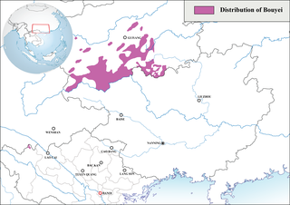
The Bouyei language is a language spoken by the Bouyei ethnic group of Southern Guizhou Province, China. Classified as a member of the Northern Tai group in the Tai language branch of the Tai–Kadai language family, the language has over 2.5 million native speakers and is also used by the Giay people in some parts of Vietnam. There are native speakers living in France or the United States as well, which emigrated from China or Vietnam. About 98% of the native speakers are in China.

<span class="mw-page-title-main">Lingui District</span> District in Guangxi, China

Lingui District is the county seat and district administered by Guilin, Guangxi, China, and located midway between Guilin and Yangshuo. The district is mostly rural and hilly, marked by the same dramatic karst topography for which Guilin is famous. Tourist attractions include Snake World, Xiongsheng Tiger and Bear Village, and Crocodile Kingdom.

<span class="mw-page-title-main">Duyun</span> County-level city in Guizhou, China

Duyun is the capital of Qiannan Buyei and Miao Autonomous Prefecture in Guizhou province, China.

The Sui language is a Kam–Sui language spoken by the Sui people of Guizhou province in China. According to Ethnologue, it was spoken by around 300,000 people in 2007. Sui is also unique for its rich inventory of consonants, with the Sandong (三洞) dialect having as many as 70 consonants. The language also has its own script, known as "Shuishu" (水書) in Chinese, which is used for ritual purposes.

Pingtang County is a county in the Qiannan Buyei and Miao Autonomous Prefecture of Guizhou province, China, bordering Guangxi to the south. It is a high mountain valley and is inhabited mainly by members of the Buyei and Miao ethnic minorities, who together make up 55% of the county's population.

The Kam–Sui languages are a branch of the Kra–Dai languages spoken by the Kam–Sui peoples. They are spoken mainly in eastern Guizhou, western Hunan, and northern Guangxi in southern China. Small pockets of Kam–Sui speakers are also found in northern Vietnam and Laos.

<span class="mw-page-title-main">Weng'an County</span> County in Guizhou, China

Weng'an County is a county in Qiannan Buyei and Miao Autonomous Prefecture, Guizhou, China.

<span class="mw-page-title-main">Ninglang Yi Autonomous County</span> Autonomous county in Yunnan, China

Ninglang Yi Autonomous County is located in the northwest of Yunnan province, China, bordering Sichuan province to the northeast. It is under the administration of Lijiang City. The county is home to the Mosuo people, who lived under the quasi-independent Chiefdom of Yongning until abolished in 1956. Ninglang Luguhu Airport is located in the county.

<span class="mw-page-title-main">Menghai County</span> County in Yunnan, China

Menghai County is a county under the jurisdiction of Xishuangbanna Dai Autonomous Prefecture, in the far south of Yunnan, China, bordering Burma's Shan State to the southwest. Meng is as variation of Mueang.

<span class="mw-page-title-main">Qingshen County</span> County in Sichuan, China

Qingshen County is a county of Sichuan Province, China. It is under the administration of the prefecture-level city of Meishan.

<span class="mw-page-title-main">Lipu, Guangxi</span> County-level city in Guangxi, China

Lipu is a county-level city in the northeast of Guangxi, China. It is under the administration of Guilin City, the downtown of which is 100 km (62 mi) to the north.

<span class="mw-page-title-main">Huanjiang Maonan Autonomous County</span> County in Guangxi, China

Huanjiang Maonan Autonomous County is an ethnic Maonan autonomous county in the north of Guangxi, China, bordering Guizhou province to the north and northwest. It is under the administration of Hechi city. It is the only Maonan autonomous county in China.

<span class="mw-page-title-main">Panzhou</span> County-level city in Guizhou, China

Panzhou is a county-level city in southwestern Guizhou province, China, on the border with Yunnan province to the west. It is under the administration of the prefecture-level city of Liupanshui.

Rongjiang County is a county in southeastern Guizhou province, China. It is under the administration of the Qiandongnan Miao and Dong Autonomous Prefecture.

<span class="mw-page-title-main">Leishan County</span> County in Guizhou, China

Leishan is a county in the east of Guizhou province, China. It is under the administration of the Qiandongnan Miao and Dong Autonomous Prefecture. More than 90% of population are ethnic Hmu.

<span class="mw-page-title-main">Sandu Shui Autonomous County</span> Autonomous county in Guizhou, China

Sandu Shui Autonomous County is an autonomous county in the southeast of Guizhou province, China. It is under the administration of the Qiannan Buyei and Miao Autonomous Prefecture, and the only Shui Autonomous County in China; 63% of Shui in China live in this county, which is the heartland of the Shui people. Per a 2022 county government publication, Sandu has a population of 381,000, 97% of whom belong to ethnic minorities, and 67% of the total population are Shui.

<span class="mw-page-title-main">Chaoyang County</span> County in Liaoning, Peoples Republic of China

Chaoyang County is a county of northwestern Liaoning province, China. It is under the administration of Chaoyang city.

<span class="mw-page-title-main">Linghai</span> County-level city in Liaoning, Peoples Republic of China

Linghai is a county-level city in the west of Liaoning province, Northeast China. It was called Jinxian or Jin County until 1993, when it was reorganized to a county-level city and renamed Linghai. With its urban core lying on the west (right) bank of the Daling River, which flows into Liaodong Bay near the city, it is under the administration of the prefecture-level city of Jinzhou, the seat of which is 21 kilometres (13 mi) to the southwest.

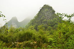
The Wulong Karst is a karst landscape located within the borders of Wulong District, Chongqing Municipality, People's Republic of China. It is divided into three areas containing the Three Natural Bridges, the Qingkou Tiankeng (箐口天坑) and Furong Cave respectively. It is a part of the Wulong Karst National Geology Park as well as part of the South China Karst, a UNESCO World Heritage Site.

Numao is a Hmongic language of China.

References

  1. 1 2 3 "South China Karst". UNESCO World Heritage Centre. United Nations Educational, Scientific, and Cultural Organization.
  2. 2023年统计用区划代码和城乡划分代码:荔波县 (in Simplified Chinese). National Bureau of Statistics of China.
  3. Zhou, Guoyan 周国炎 (2013). Zhōngguó xīnán mínzú zájū dìqū yǔyán guānxì yǔduō yǔ héxié yánjiū: Yǐ Diān Qián Guì pílín mínzú zájū dìqū wèi yánjiū gè'àn中国西南民族杂居地区语言关系与多语和谐研究:以滇黔桂毗邻民族杂居地区为研究个案 (in Chinese). Beijing: Zhongguo shehui kexue chubanshe. ISBN   978-7-5161-1985-3.
  4. 1 2 "Plenty of new airports but few passengers in China: A construction spree brings flight service to some unlikely locales, and a hoped-for spurt in air traffic fails to materialize." David Pierson / Los Angeles Times / March 12, 2010
  5. 民航机场业务量. CAAC. February 2010. Archived from the original on July 18, 2011. Retrieved April 11, 2010.
  6. 中国气象数据网 – WeatherBk Data (in Simplified Chinese). China Meteorological Administration . Retrieved 28 April 2023.
  7. 中国气象数据网 (in Simplified Chinese). China Meteorological Administration . Retrieved 28 April 2023.