Upper Franconia is a Regierungsbezirk of the state of Bavaria, southern Germany. It forms part of the historically significant region of Franconia, the others being Middle Franconia and Lower Franconia, which are all now part of the German Federal State of Bayern (Bavaria).
Bamberg is a Landkreis (district) in Bavaria, Germany. It surrounds but does not include the town of Bamberg. The district is bounded by the districts of Lichtenfels, Bayreuth, Forchheim, Erlangen-Höchstadt, Neustadt (Aisch)-Bad Windsheim, Kitzingen, Schweinfurt and Haßberge.
Coburg is a Landkreis (district) in Bavaria, Germany. It is bounded by the districts of Kronach, Lichtenfels, Bamberg and Haßberge, and by the state of Thuringia. The district surrounds, but does not include the city of Coburg.
Erlangen-Höchstadt is a Landkreis (district) in Bavaria, Germany. It is bounded by the districts of Fürth, Neustadt (Aisch)-Bad Windsheim, Bamberg, Forchheim and Nürnberger Land, and by the cities of Nuremberg and Erlangen. The city of Erlangen is not part of the district, but nonetheless its administrative seat.
Forchheim is a Landkreis (district) in Bavaria, Germany. It is bounded by the districts of Bamberg, Bayreuth, Nürnberger Land and Erlangen-Höchstadt.

Freising is a Landkreis (district) in Bavaria, Germany. Following a recent ranking of the German magazine Focus-Money comparing all German districts it is number one concerning economic growth abilities. It is bounded by the districts of Kelheim, Landshut, Erding, Munich, Dachau and Pfaffenhofen. The district is located north of the Munich metropolitan area. The Isar and Amper rivers run in parallel from southwest to northeast. North of the rivers there is the Hallertau, a hilly region mainly used for growing hop.
Haßberge is a Landkreis (district) in Bavaria, Germany. It is bounded by the districts of Coburg, Bamberg, Schweinfurt and Rhön-Grabfeld, and by the state of Thuringia.
Kronach is a Landkreis (district) in Bavaria, Germany. It is bounded by the districts of Hof, Kulmbach, Lichtenfels and Coburg, and the state of Thuringia.
Kulmbach is a Landkreis (district) in Bavaria, Germany. It is bounded by the districts of Kronach, Hof, Bayreuth and Lichtenfels.
Landsberg am Lech is a Landkreis (district) in Bavaria, Germany. It is bounded by the districts of Aichach-Friedberg, Fürstenfeldbruck, Starnberg, Weilheim-Schongau, Ostallgäu and Augsburg.
Main-Spessart is a Landkreis (district) in the northwest of Bavaria, Germany. It is located in Lower Franconia and derives its name from the river Main and the wooded hills of the Spessart.
Miesbach is a Landkreis (district) in Bavaria, Germany. It is bounded by the districts of Bad Tölz-Wolfratshausen, Munich and Rosenheim, and by the Austrian state of Tyrol.
Rhön-Grabfeld is a Landkreis (district) in Bavaria, Germany. It is bounded by the districts of Hassberge, Schweinfurt and Bad Kissingen, and the states of Hesse and Thuringia.
Roth is a Landkreis (district) in Middle Franconia, Bavaria, Germany. It is bounded by the districts of Nürnberger Land, Neumarkt, Eichstätt, Weißenburg-Gunzenhausen, Ansbach and Fürth, and the cities of Schwabach and Nürnberg.
Schweinfurt is a Landkreis (district) in the northwestern part of Bavaria, Germany. Neighboring districts are Bad Kissingen, Rhön-Grabfeld, Haßberge, Bamberg, Kitzingen, Würzburg and Main-Spessart. The district-free city Schweinfurt is surrounded by the district.

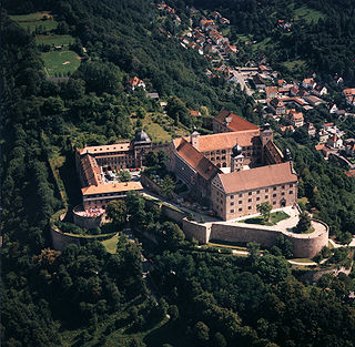
Plassenburg is a castle in the city of Kulmbach in Bavaria. It is one of the most impressive castles in Germany and a symbol of the city. It was first mentioned in 1135. The Plassenberg family were ministerial of the counts of Andechs and used as their seat the Plassenburg. The House of Guttenberg, a prominent Franconian noble family, traces its origins back to 1149 with a Gundeloh v. Blassenberg (Plassenberg). The name Guttenberg is derived from Guttenberg and was adopted by a Heinrich von Blassenberg around 1310. From 1340, the Hohenzollerns governed from Plassenburg castle their territories in Franconia till 1604. The Plassenburg was fortress and residence for the Hohenzollerns.

Lichtenfels is a town in the Upper Franconian region of Bavaria, Germany, the administrative seat of Lichtenfels district. It is chiefly known as the German "Basket City".

Bad Berneck im Fichtelgebirge is a spa town in the district of Bayreuth, in Bavaria, Germany. It is situated on the White Main river, in the Fichtel Mountains, 13 km northeast of Bayreuth. It lies in the northern part of the Bavarian province of Upper Franconia. Since 1857 it has been a spa, initially based on its climate and whey products. In 1930 it became a Kneipp spa and, in 1950, a Kneipp health spa.

The House of Andechs was a feudal line of German princes in the 12th and 13th centuries. The counts of Dießen-Andechs obtained territories in northern Dalmatia on the Adriatic seacoast, where they became Margraves of Istria and ultimately dukes of a short-lived imperial state named Merania from 1180 to 1248. They were also self-styled lords of Carniola.

The Verkehrsverbund Großraum Nürnberg is the transit authority of the city of Nuremberg, the second largest city of the German state of Bavaria. Its jurisdiction covers the city and its surrounding area, responsible for the Nuremberg S-Bahn commuter trains, the Nuremberg U-Bahn, the Nuremberg tramway and buses. While not co-extensive with the wider Nuremberg Metropolitan Region, it covers most of it with the exception of several smaller towns and rural areas on the periphery, as well as Sonneberg in the neighboring state of Thuringia.


