Hail is a form of solid precipitation. It is distinct from ice pellets, though the two are often confused. It consists of balls or irregular lumps of ice, each of which is called a hailstone. Ice pellets generally fall in cold weather, while hail growth is greatly inhibited during low surface temperatures.
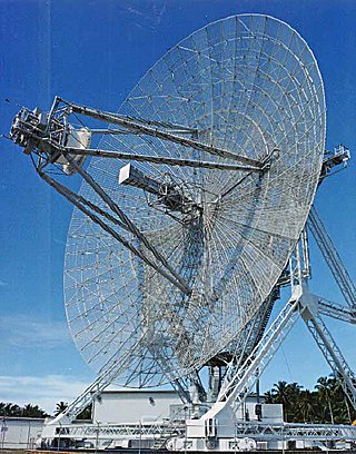
Radar is a system that uses radio waves to determine the distance (ranging), direction, and radial velocity of objects relative to the site. It is a radiodetermination method used to detect and track aircraft, ships, spacecraft, guided missiles, motor vehicles, map weather formations, and terrain.

A tornado is a violently rotating column of air that is in contact with both the surface of the Earth and a cumulonimbus cloud or, in rare cases, the base of a cumulus cloud. It is often referred to as a twister, whirlwind or cyclone, although the word cyclone is used in meteorology to name a weather system with a low-pressure area in the center around which, from an observer looking down toward the surface of the Earth, winds blow counterclockwise in the Northern Hemisphere and clockwise in the Southern. Tornadoes come in many shapes and sizes, and they are often visible in the form of a condensation funnel originating from the base of a cumulonimbus cloud, with a cloud of rotating debris and dust beneath it. Most tornadoes have wind speeds less than 180 kilometers per hour, are about 80 meters across, and travel several kilometers before dissipating. The most extreme tornadoes can attain wind speeds of more than 480 kilometers per hour (300 mph), are more than 3 kilometers (2 mi) in diameter, and stay on the ground for more than 100 km (62 mi).

Lightning is a natural phenomenon formed by electrostatic discharges through the atmosphere between two electrically charged regions, either both in the atmosphere or one in the atmosphere and one on the ground, temporarily neutralizing these in a near-instantaneous release of an average of between 200 megajoules and 7 gigajoules of energy, depending on the type. This discharge may produce a wide range of electromagnetic radiation, from heat created by the rapid movement of electrons, to brilliant flashes of visible light in the form of black-body radiation. Lightning causes thunder, a sound from the shock wave which develops as gases in the vicinity of the discharge experience a sudden increase in pressure. Lightning occurs commonly during thunderstorms as well as other types of energetic weather systems, but volcanic lightning can also occur during volcanic eruptions. Lightning is an atmospheric electrical phenomenon and contributes to the global atmospheric electrical circuit.

A thunderstorm, also known as an electrical storm or a lightning storm, is a storm characterized by the presence of lightning and its acoustic effect on the Earth's atmosphere, known as thunder. Relatively weak thunderstorms are sometimes called thundershowers. Thunderstorms occur in a type of cloud known as a cumulonimbus. They are usually accompanied by strong winds and often produce heavy rain and sometimes snow, sleet, or hail, but some thunderstorms produce little precipitation or no precipitation at all. Thunderstorms may line up in a series or become a rainband, known as a squall line. Strong or severe thunderstorms include some of the most dangerous weather phenomena, including large hail, strong winds, and tornadoes. Some of the most persistent severe thunderstorms, known as supercells, rotate as do cyclones. While most thunderstorms move with the mean wind flow through the layer of the troposphere that they occupy, vertical wind shear sometimes causes a deviation in their course at a right angle to the wind shear direction.

A mesocyclone is a meso-gamma mesoscale region of rotation (vortex), typically around 2 to 6 mi in diameter, most often noticed on radar within thunderstorms. In the northern hemisphere it is usually located in the right rear flank of a supercell, or often on the eastern, or leading, flank of a high-precipitation variety of supercell. The area overlaid by a mesocyclone’s circulation may be several miles (km) wide, but substantially larger than any tornado that may develop within it, and it is within mesocyclones that intense tornadoes form.
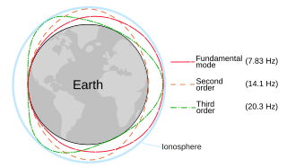
The Schumann resonances (SR) are a set of spectrum peaks in the extremely low frequency portion of the Earth's electromagnetic field spectrum. Schumann resonances are global electromagnetic resonances, generated and excited by lightning discharges in the cavity formed by the Earth's surface and the ionosphere.

A squall line, or more accurately a quasi-linear convective system (QLCS), is a line of thunderstorms, often forming along or ahead of a cold front. In the early 20th century, the term was used as a synonym for cold front. Linear thunderstorm structures often contain heavy precipitation, hail, frequent lightning, strong straight-line winds, and occasionally tornadoes or waterspouts. Particularly strong straight-line winds can occur where the linear structure forms into the shape of a bow echo. Tornadoes can occur along waves within a line echo wave pattern (LEWP), where mesoscale low-pressure areas are present. Some bow echoes can grow to become derechos as they move swiftly across a large area. On the back edge of the rainband associated with mature squall lines, a wake low can be present, on very rare occasions associated with a heat burst.
The National Severe Storms Laboratory (NSSL) is a National Oceanic and Atmospheric Administration (NOAA) weather research laboratory under the Office of Oceanic and Atmospheric Research. It is one of seven NOAA Research Laboratories (RLs).

In meteorology, an updraft is a small-scale current of rising air, often within a cloud.

The bounded weak echo region, also known as a BWER or a vault, is a radar signature within a thunderstorm characterized by a local minimum in radar reflectivity at low levels which extends upward into, and is surrounded by, higher reflectivities aloft, forming a kind of dome of weak echoes. This feature is associated with a strong updraft and is almost always found in the inflow region of a thunderstorm: it cannot be seen visually. The BWER has been noted on radar imagery of severe thunderstorms since 1973 and has a lightning detection system equivalent known as a lightning hole.

An air-mass thunderstorm, also called an "ordinary", "single cell", "isolated" or "garden variety" thunderstorm, is a thunderstorm that is generally weak and usually not severe. These storms form in environments where at least some amount of Convective Available Potential Energy (CAPE) is present, but with very low levels of wind shear and helicity. The lifting source, which is a crucial factor in thunderstorm development, is usually the result of uneven heating of the surface, though they can be induced by weather fronts and other low-level boundaries associated with wind convergence. The energy needed for these storms to form comes in the form of insolation, or solar radiation. Air-mass thunderstorms do not move quickly, last no longer than an hour, and have the threats of lightning, as well as showery light, moderate, or heavy rainfall. Heavy rainfall can interfere with microwave transmissions within the atmosphere.
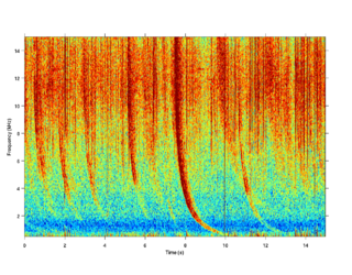
A radio atmospheric signal or sferic is a broadband electromagnetic impulse that occurs as a result of natural atmospheric lightning discharges. Sferics may propagate from their lightning source without major attenuation in the Earth–ionosphere waveguide, and can be received thousands of kilometres from their source. On a time-domain plot, a sferic may appear as a single high-amplitude spike in the time-domain data. On a spectrogram, a sferic appears as a vertical stripe that may extend from a few kHz to several tens of kHz, depending on atmospheric conditions.
Convective storm detection is the meteorological observation, and short-term prediction, of deep moist convection (DMC). DMC describes atmospheric conditions producing single or clusters of large vertical extension clouds ranging from cumulus congestus to cumulonimbus, the latter producing thunderstorms associated with lightning and thunder. Those two types of clouds can produce severe weather at the surface and aloft.
Optical heterodyne detection is a method of extracting information encoded as modulation of the phase, frequency or both of electromagnetic radiation in the wavelength band of visible or infrared light. The light signal is compared with standard or reference light from a "local oscillator" (LO) that would have a fixed offset in frequency and phase from the signal if the latter carried null information. "Heterodyne" signifies more than one frequency, in contrast to the single frequency employed in homodyne detection.

The distribution of lightning, or the incidence of individual strikes, in any particular place is highly dependent on its location, climate, and time of year. Lightning does have an underlying spatial distribution. High quality lightning data has only recently become available, but the data indicates that lightning occurs on average 44±5 times every second over the entire Earth, making a total of about 1.4 billion flashes per year.
The following is a glossary of tornado terms. It includes scientific as well as selected informal terminology.

This glossary of meteorology is a list of terms and concepts relevant to meteorology and atmospheric science, their sub-disciplines, and related fields.
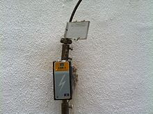
ALDIS is a sensor network in Austria for the detection and localization of lightning discharge occurring during thunderstorms. In addition to the location of the strike point, the associated peak current is also estimated. ALDIS is a member of the pan-European lightning detection project EUCLID.