List of Louisiana parishes by French-speaking population

Last updated
French spread in Louisiana. Parishes marked in yellow are those where 4-10% of the population speak French or Cajun French at home, orange 10-15%, red 15-20%, brown 20-30%. Louisiana French.svg
French spread in Louisiana. Parishes marked in yellow are those where 4–10% of the population speak French or Cajun French at home, orange 10–15%, red 15–20%, brown 20–30%.

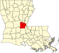
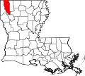
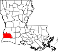
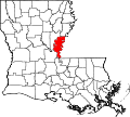
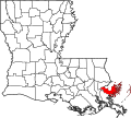
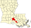
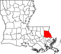
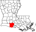
The list of Louisiana parishes by French-speaking population was created from the 2000 Census of the United States. [1] Census collects data on languages spoken at home by inhabitants of Louisiana five years of age or more. Responses "French" and "Cajun" are included.

Contents

Statewide, out of a population 5 years and older of 4,152,122, some 179,750 people reported French as their home language, while 14,365 reported "Cajun". A further 4,465 who reported French Creole are not counted below.

According to the 2010 US Census, there was a huge decline in the number of French speakers in Louisiana. It now stands at 115,183 which equates to 2.8% of the state population. [2]

Complete Parish listing

[3]

Name of parishTotal population 5 and older 2000French-speaking population 5 and older 2000Percentage French-speaking 2000French-speaking population 5 and older 2010Percentage French-speaking 2010 Map
Lafayette [lower-alpha 1] 176,05125,30014.37%20,76910% Map of Louisiana highlighting Lafayette Parish.svg
Lafourche [lower-alpha 2] 83,51815,98419.12%13,52515% Map of Louisiana highlighting Lafourche Parish.svg
St. Landry [lower-alpha 1] 80,66813,47516.70%7,84110.08% Map of Louisiana highlighting Saint Landry Parish.svg
Vermilion [lower-alpha 1] 49,84212,41024.89%9,76618% Map of Louisiana highlighting Vermilion Parish.svg
St. Martin [lower-alpha 1] 44,77912,29027.44%8,67518% Map of Louisiana highlighting Saint Martin Parish.svg
Acadia [lower-alpha 1] 54,11410,31019.04%8,08814% Map of Louisiana highlighting Acadia Parish.svg
Terrebonne [lower-alpha 2] 96,30910,27510.66%7,8737.65% Map of Louisiana highlighting Terrebonne Parish.svg
Calcasieu [lower-alpha 2] 169,74510,1705.98%7,2924.15% Map of Louisiana highlighting Calcasieu Parish.svg
Evangeline [lower-alpha 1] 32,4548,34525.71%5,74018% Map of Louisiana highlighting Evangeline Parish.svg
Iberia [lower-alpha 1] 67,3748,08911.99%5,6668.35% Map of Louisiana highlighting Iberia Parish.svg
East Baton Rouge 382,7417,9252.07%4,1954% Map of Louisiana highlighting East Baton Rouge Parish.svg
Jefferson [lower-alpha 2] 424,6007,7631.82%4,1651% Map of Louisiana highlighting Jefferson Parish.svg
Avoyelles [lower-alpha 2] 38,4686,78917.64%4,33111.07% Map of Louisiana highlighting Avoyelles Parish.svg
Orleans 450,8945,8051.28% Map of Louisiana highlighting Orleans Parish.svg
Jefferson Davis 28,8444,66016.15%3,22311.07% Map of Louisiana highlighting Jefferson Davis Parish.svg
Assumption [lower-alpha 2] 21,7133,81917.58%2,67612.15% Map of Louisiana highlighting Assumption Parish.svg
St. Mary [lower-alpha 1] 49,3452,6855.43% Map of Louisiana highlighting Saint Mary Parish.svg
Rapides 116,8662,1891.86% Map of Louisiana highlighting Rapides Parish.svg
St. Tammany 177,0922,1601.21% Map of Louisiana highlighting Saint Tammany Parish.svg
Ascension [lower-alpha 2] 70,0931,9442.76% Map of Louisiana highlighting Ascension Parish.svg
Caddo 233,8121,9440.82% Map of Louisiana highlighting Caddo Parish.svg
Allen 23,5711,4686.22% Map of Louisiana highlighting Allen Parish.svg
Livingston 84,6941,3441.58% Map of Louisiana highlighting Livingston Parish.svg
St. Charles [lower-alpha 2] 44,1521,1892.69% Map of Louisiana highlighting Saint Charles Parish.svg
Tangipahoa 93,0021,0841.16% Map of Louisiana highlighting Tangipahoa Parish.svg
Cameron [lower-alpha 2] 9,2791,07511.57% Map of Louisiana highlighting Cameron Parish.svg
Pointe Coupee [lower-alpha 2] 21,1391,0354.89% Map of Louisiana highlighting Pointe Coupee Parish.svg
Ouachita 136,2641,0300.75% Map of Louisiana highlighting Ouachita Parish.svg
Iberville [lower-alpha 2] 31,0351,0053.23% Map of Louisiana highlighting Iberville Parish.svg
St. James [lower-alpha 2] 19,6849804.97% Map of Louisiana highlighting Saint James Parish.svg
St. Bernard 62,8129151.44% Map of Louisiana highlighting Saint Bernard Parish.svg
Plaquemines 24,5818553.47% Map of Louisiana highlighting Plaquemines Parish.svg
St. John the Baptist [lower-alpha 2] 39,2207351.86% Map of Louisiana highlighting Saint John the Baptist Parish.svg
West Baton Rouge [lower-alpha 2] 20,0126753.36% Map of Louisiana highlighting West Baton Rouge Parish.svg
East Feliciana 19,8535742.88% Map of Louisiana highlighting East Feliciana Parish.svg
Beauregard 30,5595701.86% Map of Louisiana highlighting Beauregard Parish.svg
Lincoln 39,5735101.28% Map of Louisiana highlighting Lincoln Parish.svg
Bossier 90,5874740.51% Map of Louisiana highlighting Bossier Parish.svg
Washington 40,7383640.89% Map of Louisiana highlighting Washington Parish.svg
Vernon 47,0483500.74% Map of Louisiana highlighting Vernon Parish.svg
Natchitoches 36,0823390.93% Map of Louisiana highlighting Natchitoches Parish.svg
Webster 39,1102430.62% Map of Louisiana highlighting Webster Parish.svg
Grant 17,2232301.32% Map of Louisiana highlighting Grant Parish.svg
De Soto 23,6072300.97% Map of Louisiana highlighting DeSoto Parish.svg
Concordia 18,6981901.01% Map of Louisiana highlighting Concordia Parish.svg
Sabine 21,8301900.86% Map of Louisiana highlighting Sabine Parish.svg
La Salle 13,2811671.25% Map of Louisiana highlighting LaSalle Parish.svg
West Feliciana 14,3381591.10% Map of Louisiana highlighting West Feliciana Parish.svg
Jackson 14,3631481.03% Map of Louisiana highlighting Jackson Parish.svg
Richland 19,3191000.51% Map of Louisiana highlighting Richland Parish.svg
Catahoula 10,183990.97% Map of Louisiana highlighting Catahoula Parish.svg
Union 21,129950.44% Map of Louisiana highlighting Union Parish.svg
West Carroll 11,507830.72% Map of Louisiana highlighting West Carroll Parish.svg
Caldwell 9,868790.80% Map of Louisiana highlighting Caldwell Parish.svg
Bienville 14,699790.53% Map of Louisiana highlighting Bienville Parish.svg
Franklin 19,649790.40% Map of Louisiana highlighting Franklin Parish.svg
Morehouse 28,735750.26% Map of Louisiana highlighting Morehouse Parish.svg
Winn 15,783640.40% Map of Louisiana highlighting Winn Parish.svg
East Carroll 8,585550.64% Map of Louisiana highlighting East Carroll Parish.svg
Tensas 6,144350.56% Map of Louisiana highlighting Tensas Parish.svg
Claiborne 15,794350.22% Map of Louisiana highlighting Claiborne Parish.svg
St. Helena 9,690300.30% Map of Louisiana highlighting Saint Helena Parish.svg
Madison 12,555250.19% Map of Louisiana highlighting Madison Parish.svg
Red River 8,854200.22% Map of Louisiana highlighting Red River Parish.svg
Louisiana total4,152,122194,1154.66%115,1832.8%

See also

Notes

Related Research Articles

Louisiana U.S. state

Louisiana is a state in the Deep South and South Central regions of the United States. It is the 19th-smallest by area and the 25th most populous of the 50 U.S. states. Louisiana is bordered by the state of Texas to the west, Arkansas to the north, Mississippi to the east, and the Gulf of Mexico to the south. A large part of its eastern boundary is demarcated by the Mississippi River. Louisiana is the only U.S. state with political subdivisions termed parishes, which are equivalent to counties, making it one of only two U.S. states not subdivided into counties. The state's capital is Baton Rouge, and its largest city is New Orleans.

Vermilion Parish, Louisiana Parish in Louisiana, United States

Vermilion Parish is a parish located in the U.S. state of Louisiana, created in 1844. The parish seat is Abbeville. Vermilion Parish is part of the Lafayette metropolitan statistical area, and located in southern Acadiana. At the 2010 U.S. census, the population was 57,999; the 2019 American Community Survey estimated its population was 59,865.

Lafayette Parish, Louisiana Parish in Louisiana, United States

Lafayette Parish is a parish located in the U.S. state of Louisiana. According to the 2020 U.S. census, the parish had a population of 241,753, up from 221,578 at the 2010 United States census. The parish seat is the city of Lafayette. The parish was founded in 1823. Since 1992, Lafayette City and Lafayette Parish have operated as a consolidated government.

Ascension Parish, Louisiana Parish in Louisiana, United States

Ascension Parish is a parish located in the U.S. state of Louisiana. As of the 2020 census, the population was 126,500. Its parish seat is Donaldsonville. The parish was created in 1807. Ascension Parish is part of the Baton Rouge metropolitan statistical area.

Rayne, Louisiana City in Louisiana, United States

Rayne is a city in the U.S. state of Louisiana, in Acadia Parish. With a population of 7,326 at the 2020 United States census, it is nicknamed the "Frog Capital of the World", as well as the "Louisiana City of Murals". Rayne is part of the Crowley micropolitan statistical area, and within the Lafayette metropolitan statistical area in Acadiana.

Pierre Part, Louisiana Census-designated place in Louisiana, United States

Pierre Part is a census-designated place (CDP) in Assumption Parish, Louisiana, United States. The population was 3,169 at the 2010 census, making it the most populous community in Assumption Parish. With 39.3 percent of the population speaking French at home, Pierre Part is the most French town in the United States outside of Maine. Pierre Part is known locally for its prominent French influence and ancestry, which have become significant aspects of its contemporary local culture. Situated near Lake Verret, Pierre Part is a popular local destination for water sports and fishing during the summer.

Lake Charles, Louisiana City in Louisiana, United States

Lake Charles is the fifth-largest incorporated city in the U.S. state of Louisiana, located on Lake Charles, Prien Lake, and the Calcasieu River. Founded in 1861 in Calcasieu Parish, it is a major industrial, cultural, and educational center in the southwest region of the state. As of the 2020 census, Lake Charles's population was 84,872. It is considered a regionally significant center of petrochemical refining, gambling, tourism, and education, being home to McNeese State University and Sowela Technical Community College. Because of the lakes and waterways throughout the city, metropolitan Lake Charles is often called the Lake Area.

Lafayette, Louisiana City in the US state of Louisiana

Lafayette is a city in the U.S. state of Louisiana, and the most populous and parish seat of Lafayette Parish, located along the Vermilion River. It is Louisiana's fourth largest incorporated municipality by population and the 234th-most populous in the United States, with a 2020 census population of 121,374; the consolidated city–parish's population was 241,753 in 2020. The Lafayette metropolitan area was Louisiana's third largest metropolitan statistical area with a population of 478,384 at the 2020 census, overtaking the Shreveport–Bossier City metropolitan area in 2015. The Acadiana region containing Lafayette is the largest population and economic corridor between Houston, Texas, and New Orleans.

Monroe, Louisiana City in Louisiana, United States

Monroe is the eighth-largest city in the U.S. state of Louisiana, and parish seat of Ouachita Parish. With a 2020 census-tabulated population of 47,702, it is the principal city of the Monroe metropolitan statistical area, the second-largest metropolitan area in North Louisiana.

Belle Chasse, Louisiana Census-designated place in Louisiana, United States

Belle Chasse is a census-designated place (CDP) in Plaquemines Parish, Louisiana, United States, on the west bank of the Mississippi River. Belle Chasse is part of the Greater New Orleans metropolitan area. The population was 10,579 at the 2020 United States census. Belle Chasse is the largest community in Plaquemines Parish. It is home to Naval Air Station Joint Reserve Base New Orleans, a Naval Air Station for the U.S. Navy Reserve.

Cecilia, Louisiana Census-designated place in Louisiana, United States

Cecilia is a census-designated place (CDP) in St. Martin Parish, in the U.S. state of Louisiana. The community lies within the region of Acadiana, and the Lafayette metropolitan statistical area. It had a population of 1,505 at the 2000 U.S. census, estimated to have grown to 1,917 in 2019 at the American Community Survey's 5-year estimates.

St. Martinville, Louisiana City in Louisiana, United States

St. Martinville is a city in, and the parish seat of, St. Martin Parish, Louisiana, United States. It lies on Bayou Teche, 13 miles (21 km) south of Breaux Bridge, 16 miles (26 km) southeast of Lafayette, and 9 miles (14 km) north of New Iberia. The population was 6,114 at the 2010 U.S. census, and 5,379 at the 2020 United States census. It is part of the Lafayette metropolitan statistical area.

Houma, Louisiana City in Louisiana, United States

Houma is the largest city in, and the parish seat of, Terrebonne Parish in the U.S. state of Louisiana. It is also the largest principal city of the Houma–Bayou Cane–Thibodaux metropolitan statistical area. The city's government was absorbed by the parish in 1984, which currently operates as the Terrebonne Parish Consolidated Government.

Maurice, Louisiana Village in Louisiana, United States

Maurice is a village in Vermilion Parish, Louisiana, United States. The population was 964 at the 2010 census, and 1,857 at the 2020 population estimates program. It is part of the Abbeville micropolitan statistical area.

Eunice, Louisiana City in Louisiana, United States

Eunice is a city in Acadia and St. Landry parishes in the U.S. state of Louisiana. The 2010 census placed the population at 10,398, a decrease of 1,101, or 9.5 percent, from the 2000 tabulation of 11,499.

Delcambre, Louisiana Town in Louisiana, United States

Delcambre is a town in Iberia and Vermilion parishes in the U.S. state of Louisiana, located 9 miles (14 km) east of Abbeville on Louisiana Highway 14 in the Cajun Heartland of Acadiana. Bayou Carlin, also known as the Delcambre Canal, passes through the town and is home for much of the local fishing industry. The population was 1,866 at the 2010 census, down from 2,168 at the 2000 census.

Arnaudville, Louisiana Town in Louisiana, United States

Arnaudville is a town in St. Landry and St. Martin parishes in the U.S. state of Louisiana. The St. Martin Parish portion of Arnaudville is part of the Lafayette metropolitan statistical area, while the St. Landry Parish portion is part of the Opelousas–Eunice micropolitan statistical area. At the 2020 population estimates program, it had a population of 1,041.

Council for the Development of French in Louisiana

The Council for the Development of French in Louisiana is Louisiana's Office of Francophone Affairs. It is a state agency whose multiple legislative mandates include developing opportunities to use the French language in tourism, economic development, culture, education and international relations. CODOFIL is governed by a board of 23 members and administratively placed within the Louisiana Office of Cultural Development's Department of Culture, Recreation and Tourism, overseen by the Lieutenant Governor. CODOFIL is the only state agency in the United States whose purpose is to serve a linguistic population.

Demographics of Louisiana Overview of the demographics of Louisiana

Louisiana is the second-most populous South Central U.S. state, with a 2020 U.S. census resident population of 4,657,757, and apportioned population of 4,661,468. Much of the state's population is concentrated in southern Louisiana in the Greater New Orleans, Florida Parishes, and Acadiana regions, with the remainder in North and Central Louisiana's major metropolitan areas. The center of population of Louisiana is located in Pointe Coupee Parish, in the city of New Roads.

References

  1. "Language Map Data Center" . Retrieved 2010-03-02.
  2. "Archived copy". Archived from the original on 2006-06-19. Retrieved 2007-10-22.{{cite web}}: CS1 maint: archived copy as title (link)
  3. "Archived copy". Archived from the original on 2013-08-15. Retrieved 2013-08-06.{{cite web}}: CS1 maint: archived copy as title (link)