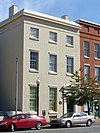
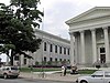
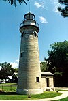
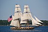
Marker title Image Date dedicated Location Marker type Topics African Americans in Battle of Lake Erie September 10, 1996 Erie Maritime Museum ,Erie City African American, Military, War of 1812 Anthony Wayne November 1946 East 6th Street at Ash Street, Erie Roadside American Revolution, Forts, Military Canal Basin April 5, 1948 North end of State State, Erie Roadside Canals, Navigation, Transportation Captain C.V. Gridley November 1946 East Lake Road, Erie Roadside Military, Military Post-Civil War Captain Daniel Dobbins September 13, 2003 Dobbins Landing , foot of State Street, Erie 42°08′16″N 80°05′27″W / 42.13768°N 80.09075°W / 42.13768; -80.09075 (Captain Daniel Dobbins ) Roadside George Washington, Military, War of 1812 Cashier's House 1980 417 State Street, Erie 42°07′52″N 80°05′10″W / 42.131°N 80.0862°W / 42.131; -80.0862 (Cashier's House ) Roadside Buildings, Business & Industry, Houses & Homesteads Circus History August 21, 1974 US 20 at the Diamond in Girard 42°00′00″N 80°19′01″W / 42.00007°N 80.31697°W / 42.00007; -80.31697 (Circus History ) Roadside Performers Climax Locomotives May 17, 1987 PA 77 at south end of Corry 41°55′11″N 79°38′38″W / 41.91962°N 79.64378°W / 41.91962; -79.64378 (Climax Locomotives ) Roadside Business & Industry, Railroads, Transportation Col. Philip Cochran November 11, 2001 Erie County World War II Memorial,Erie Roadside Military, Military Post-Civil War Col. Strong Vincent May 1, 1994 Northeast corner of High Street and 1st Street, Waterford 41°56′25″N 79°58′58″W / 41.94037°N 79.98285°W / 41.94037; -79.98285 (Col. Strong Vincent ) Roadside Civil War, Military Colt's Station October 29, 1951 PA 89 at PA 430 , Greenfield Township 42°07′08″N 79°49′28″W / 42.11883°N 79.82435°W / 42.11883; -79.82435 (Colt's Station ) Roadside Government & Politics, Government & Politics 18th Century, Navigation, Transportation Corry State Fish Hatchery July 15, 2010 13365 US 6 , Corry 41°55′51″N 79°40′16″W / 41.93089°N 79.67114°W / 41.93089; -79.67114 (Corry State Fish Hatchery ) Roadside Environment, Government & Politics 20th Century, Sports Creation of the Pennsylvania Game Commission July 24, 2008 Northwest corner of Corry City Park, at the intersection of North Center and Smith Streets Roadside Environment, Government & Politics 20th Century Drake Well Park November 20, 1946 PA 8 just south of Union City 41°53′22″N 79°50′50″W / 41.88958°N 79.84712°W / 41.88958; -79.84712 (Drake Well Park ) Roadside Business & Industry, Oil & Gas Edinboro State College May 31, 1968 US 6N at the campus in Edinboro 41°52′44″N 80°06′58″W / 41.8788°N 80.11615°W / 41.8788; -80.11615 (Edinboro State College ) City Education Edinboro State Teachers College May 31, 1968 PA 99 in front of college, Edinboro (Missing) City Education Erie November 1, 1946 US 20 , west of Erie Roadside Cities & Towns, Early Settlement, Forts, Military Erie November 1, 1946 US 20 , east of Erie Roadside Cities & Towns, Forts, Military, War of 1812 Erie November 1, 1946 US 19 , south of Erie 42°02′37″N 80°04′28″W / 42.04369°N 80.0745°W / 42.04369; -80.0745 (Erie ) Roadside Cities & Towns, Forts, Military, War of 1812 Erie County August 21, 1981 County Courthouse,Peach and Sassafras Streets, Erie City Government & Politics, Government & Politics 19th Century, Military, Native American Erie Extension Canal April 30, 1948 PA 18 at Platea 41°57′05″N 80°19′45″W / 41.95135°N 80.3291°W / 41.95135; -80.3291 (Erie Extension Canal ) Roadside Canals, Navigation, Transportation Erie Extension Canal April 30, 1948 US 20 at Asbury Road, Millcreek Township 42°04′18″N 80°10′57″W / 42.07158°N 80.18237°W / 42.07158; -80.18237 (Erie Extension Canal ) Roadside Canals, Navigation, Transportation Erie Land Lighthouse June 19, 2004 At the site of the lighthouse, 2 Lighthouse Street, Erie City Buildings, Navigation Flagship Niagara 1948 At property on State Street, Erie Roadside Military, War of 1812 Fort Le Boeuf (Plaque) August 1, 1922 US 19 , opposite Fort Le Boeuf Museum, Waterford 41°56′24″N 79°58′59″W / 41.94008°N 79.98297°W / 41.94008; -79.98297 (Fort Le Boeuf - PLAQUE ) Plaque Forts, French & Indian War, George Washington, Military Fort LeBoeuf November 1, 1946 US 19 in Waterford 41°56′25″N 79°58′57″W / 41.94015°N 79.98262°W / 41.94015; -79.98262 (Fort LeBoeuf ) Roadside Forts, French & Indian War, Military, Native American Fort LeBoeuf Memorial September 19, 1951 Property on US 19 , Waterford 41°56′25″N 79°58′58″W / 41.94037°N 79.98275°W / 41.94037; -79.98275 (Fort LeBoeuf Memorial ) Roadside Forts, French & Indian War, George Washington, Military Fort Presque Isle October 1, 1946 6th and Parade Streets, Erie 42°07′57″N 80°04′37″W / 42.1326°N 80.07692°W / 42.1326; -80.07692 (Fort Presque Isle ) Roadside Forts, French & Indian War, Military, Native American, Roads French Creek November 1, 1946 US 19 , slightly north of US 6 , south of Waterford 41°53′05″N 79°59′58″W / 41.88482°N 79.99943°W / 41.88482; -79.99943 (French Creek ) Roadside Early Settlement, Ethnic & Immigration, George Washington, Transportation George Washington November 1, 1946 US 19 , at George Washington Memorial Park, Waterford 41°56′24″N 79°58′58″W / 41.94007°N 79.98282°W / 41.94007; -79.98282 (George Washington ) Roadside French & Indian War, George Washington, Government & Politics, Government & Politics 18th Century, Military Harry Kellar (1849– 1922) May 9, 2008 Griswold Park, south side of West 13th Street, between Peach and Sassafras Streets, Erie Roadside Performers, Professions & Vocations Harry T. Burleigh February 21, 1952 East 6th Street, Erie Roadside African American, Music & Theater, Performers Ida M. Tarbell September 28, 1950 PA 8 near Hatch Hollow Road, southwest of Wattsburg 41°57′51″N 79°51′06″W / 41.9641°N 79.85165°W / 41.9641; -79.85165 (Ida M. Tarbell ) Roadside Abraham Lincoln, Oil & Gas, Women, Writers John Nelson (1917– 1959) September 18, 2004 3923 Main Street, Lawrence Park Township City Civil Rights, Government & Politics 20th Century, Labor Joshua M. Merrill (1828– 1904) July 24, 2004 Between 19 and 37 North Center Street, Corry Roadside Invention, Oil & Gas, Professions & Vocations LP Gas Industry May 17, 1962 US 19 at square in Waterford (Missing) Roadside Business & Industry, Oil & Gas Old Custom House November 1, 1946 State Street, Erie (Missing) Roadside Buildings, Business & Industry, Houses & Homesteads Old French Road November 1, 1946 Old French Road , south of Erie 42°05′32″N 80°03′26″W / 42.09218°N 80.05717°W / 42.09218; -80.05717 (Old French Road ) Roadside Native American, Paths & Trails, Roads, Transportation Old State Line November 1946 PA 99 at McKean Roadside Government & Politics, Government & Politics 18th Century Old State Line November 1, 1946 West Lake Road at Happy Valley Road, Springfield Township 41°59′59″N 80°24′20″W / 41.99983°N 80.40553°W / 41.99983; -80.40553 (Old State Line ) Roadside Government & Politics, Government & Politics 18th Century Old State Line November 1, 1946 Main Street at Wattsburg 41°59′57″N 79°48′40″W / 41.99925°N 79.81098°W / 41.99925; -79.81098 (Old State Line ) Roadside Government & Politics, Government & Politics 18th Century Old State Line November 1946 US 19 , Waterford Roadside Government & Politics, Government & Politics 18th Century Old State Line November 1946 US 20 at Girard Roadside Government & Politics, Government & Politics 18th Century Otto Maya August 17, 2002 10th and State Streets, Erie (Missing) Roadside Sports Paul Allman Siple (1908– 1968) October 14, 2007 Plaza at Erie Maritime Museum , 150 East Front Street, Erie Roadside Exploration, Invention, Professions & Vocations Pennsylvania April 12, 1949 PA 5 , at the Pennsylvania– Ohio border (Missing) Roadside Government & Politics, Government & Politics 17th Century, William Penn Pennsylvania April 12, 1949 US 20 , at the Pennsylvania– Ohio border 41°56′41″N 80°31′00″W / 41.9446°N 80.51673°W / 41.9446; -80.51673 (Pennsylvania ) Roadside Government & Politics, Government & Politics 17th Century, William Penn Pennsylvania April 12, 1949 At I-90 Welcome Center, just west of Pennsylvania– New York border Roadside Government & Politics, Government & Politics 17th Century, William Penn Perry's Shipyards November 1946 6th and Cascade Streets, Erie Roadside Business & Industry, Military Presque Isle Portage November 1, 1946 Peach Street near Lane Road, north of Waterford 41°58′50″N 80°00′55″W / 41.98068°N 80.0154°W / 41.98068; -80.0154 (Presque Isle Portage ) Roadside Native American, Paths & Trails, Roads, Transportation Sr. Bernard Sheridan September 26, 2003 Saint Vincent Hospital, 232 West 25th Street, Erie 42°06′39″N 80°04′39″W / 42.1108°N 80.0775°W / 42.1108; -80.0775 (Sr. Bernard Sheridan ) City Education, Medicine & Science, Professions & Vocations, Women St. James A. M. E. Church 1994 East 12th Street at Holland Street in Erie City African American, Religion U.S.S. Wolverine September 3, 1953 North end of State Street, Erie City Civil War, Military