List of airports in Grenada

Last updated

Map of Grenada Grenada-CIA WFB Map.png
Map of Grenada

This is a list of airports in Grenada.

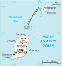
Grenada is an island country and sovereign state in the southeastern Caribbean Sea. It consists of the island of Grenada and smaller islands at the southern end of the Grenadines, including Carriacou, Petit Martinique, Ronde Island, Caille Island, Diamond Island, Large Island, Saline Island, and Frigate Island. The main island of Grenada is divided into six parishes. The capital is St. George's. Grenada is located northwest of Trinidad and Tobago, northeast of Venezuela, and southwest of Saint Vincent and the Grenadines.

Contents

Airports

Airport names shown in bold indicate the airport has scheduled service on commercial airlines.

Parish Island ICAO IATA Airport name Coordinates
St. George's Saint George Grenada TGPYGND Maurice Bishop International Airport 12°00′15″N061°47′10″W / 12.00417°N 61.78611°W / 12.00417; -61.78611 (Maurice Bishop International Airport)
Grenville Saint Andrew Grenada TGPG Pearls Airport 12°08′37″N061°37′00″W / 12.14361°N 61.61667°W / 12.14361; -61.61667 (Pearls Airport)
Hillsborough Carriacou TGPZCRU Lauriston Airport (Carriacou Island Airport) 12°28′37″N061°28′20″W / 12.47694°N 61.47222°W / 12.47694; -61.47222 (Lauriston Airport)

See also

Map all coordinates using: OpenStreetMap  
Download coordinates as: KML

References