Related Research Articles
Uray Airport is an airport in Khanty-Mansi Autonomous Okrug, Russia located 4 km southeast of Uray. It services up to medium-sized airliners.
Ngaoundéré Airport, also known as N'Gaoundéré Airport, is an airport serving Ngaoundéré, the capital of the Adamawa Province in Cameroon.

Garoua Airport, also known as Garoua International Airport, is an airport serving Garoua, the capital of North Province, Cameroon.
Assiut Airport is an airport in Assiut, Egypt.
Amborovy Airport, also known as Philibert Tsiranana Airport, is an airport in Mahajanga, Madagascar.

Denizli Çardak Airport is an airport located in Çardak, Denizli Province, Turkey. It is the airport serving the Aegan city of Denizli. The airport is operated by the General Directorate of State Airports, as is the case with many other airports in Turkey.

Muş "Sultan Alparslan" Airport is an airport in Muş, Turkey.
Tachilek Airport or Tachileik Airport is an airport serving Tachilek (Tachileik), a town in the Shan State of eastern Myanmar.

Yenişehir Airport is an international airport in the city of Yenişehir in the Bursa Province of Turkey.

Eskişehir Air Base is a military airport in the city of Eskişehir, Turkey.
Bislig Airport is an airport serving the general area of Bislig, located in the province of Surigao del Sur in the Philippines. The airport is classified as a community airport by the Civil Aviation Authority of the Philippines, a body of the Department of Transportation that is responsible for the operations of not only this airport but also of all other airports in the Philippines except the major international airports.
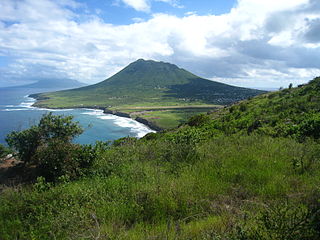
F. D. Roosevelt Airport is the airport located on the island of Sint Eustatius, Caribbean Netherlands. It was opened as "Golden Rock Airport" in 1946 and renamed for Franklin Delano Roosevelt. As of 2012, the only commercial aircraft that serves the island is the DHC-6 Twin Otter, although the runway can accommodate larger turboprop aircraft and some smaller jets. As of 2023, the largest aircraft type to operate at the airport is the ATR 42.
Phetchabun Airport is in Lan Ba subdistrict, Lom Sak district, Phetchabun province in northern Thailand.
Bolívar Airport is an airport serving Bolívar, a town in Bolívar Partido, Buenos Aires Province, Argentina.
Bafoussam Airport is an airport serving Bafoussam, capital of the West Province of Cameroon.
Foumban Nkounja Airport is an airport serving Foumban, a city in the Noun Department of the West Province in Cameroon. It is also known as Foumban Airport. The airport is located southwest of Foumban in Koutaba,. Some sources also wrongly refer to it as the Koutaba Airport.
Siglufjörður Airport or Siglufjordur Airport is an airport serving Siglufjörður, Iceland.
Jeongseok Airport is a small airport located near the city of Seogwipo, in Jeju province in South Korea. The airport is owned by Korean Air and is used as an aviation training centre. The name of the airport originated by the art name of Cho Choong-hoon, the founder of Hanjin Group.
References

- Sources
- "UN Location Codes: Netherlands Antilles][includes IATA codes". UN/LOCODE 2006-2. UNECE. 2007-04-30.
- Notes
- ↑ "Airport information for TNCB". World Aero Data. Archived from the original on 2019-03-05.
{{cite web}}: CS1 maint: unfit URL (link) Data current as of October 2006. Source: DAFIF. - ↑ Airport information for BON at Great Circle Mapper. Source: DAFIF (effective October 2006).
Accident history for BON at Aviation Safety Network - ↑ "Airport information for TNCC". World Aero Data. Archived from the original on 2019-03-05.
{{cite web}}: CS1 maint: unfit URL (link) Data current as of October 2006. Source: DAFIF. - ↑ Airport information for CUR at Great Circle Mapper. Source: DAFIF (effective October 2006).
Accident history for CUR at Aviation Safety Network - ↑ Airport information for TNCS/SAB at Great Circle Mapper. Source: DAFIF (effective October 2006).
- ↑ Accident history for SAB at Aviation Safety Network
- ↑ "Airport information for TNCE". World Aero Data. Archived from the original on 2019-03-05.
{{cite web}}: CS1 maint: unfit URL (link) Data current as of October 2006. Source: DAFIF. - ↑ Airport information for EUX at Great Circle Mapper. Source: DAFIF (effective October 2006).
Accident history for EUX at Aviation Safety Network - ↑ "Airport information for TNCM". World Aero Data. Archived from the original on 2019-03-05.
{{cite web}}: CS1 maint: unfit URL (link) Data current as of October 2006. Source: DAFIF. - ↑ Airport information for SXM at Great Circle Mapper. Source: DAFIF (effective October 2006).
Accident history for SXM at Aviation Safety Network