List of electoral wards in Rutland

Last updated

This is a list of electoral divisions and wards in the ceremonial county of Rutland in the East Midlands. All changes since the re-organisation of local government following the passing of the Local Government Act 1972 are shown. The number of councillors elected for each electoral division or ward is shown in brackets.

Contents

Unitary authority council

Rutland

Wards from 1 April 1974 (first election 7 June 1973) to 3 May 1979: [1]

Wards from 3 May 1979 to 1 May 2003: [2] [3]

Wards from 1 May 2003 to 2019: [4]

Rutland UK ward map (blank).svg
  1. Braunston & Belton (1)
  2. Cottesmore (2)
  3. Exton (1)
  4. Greetham (1)
  5. Ketton (2)
  6. Langham (1)
  7. Lyddington (1)
  8. Martinsthorpe (1)
  9. Normanton (2)
  10. Oakham North East (2)
  11. Oakham North West (2)
  12. Oakham South East (2)
  13. Oakham South West (2)
  14. Ryhall & Casterton (2)
  15. Uppingham (3)
  16. Whissendine (1)

Wards from May 2019 to present: [5]

  1. Barleythorpe (2)
  2. Braunston & Martinsthorpe (2)
  3. Cottesmore (2)
  4. Exton (1)
  5. Greetham (1)
  6. Ketton (2)
  7. Langham (1)
  8. Lyddington (1)
  9. Martinsthorpe (1)
  10. Normanton (2)
  11. Oakham North East (2)
  12. Oakham North West (2)
  13. Oakham South (3)
  14. Ryhall & Casterton (2)
  15. Uppingham (3)
  16. Whissendine (1)

Electoral wards by constituency

Rutland and Melton

Asfordby, Bottesford, Braunston and Belton, Cottesmore, Croxton Kerrial, Exton, Frisby-on-the-Wreake, Gaddesby, Greetham, Ketton, Langham, Long Clawson and Stathern, Lyddington, Martinsthorpe, Melton Craven, Melton Dorian, Melton Egerton, Melton Newport, Melton Sysonby, Melton Warwick, Normanton, Oakham North East, Oakham North West, Oakham South East, Oakham South West, Old Dalby, Ryhall and Casterton, Somerby, Uppingham, Waltham-on-the-Wolds, Whissendine, Wymondham.

Related Research Articles

The history of the English county of Rutland, located in the East Midlands. It was reconstituted as a district of Leicestershire in 1974 by the Local Government Act 1972. This district was given unitary authority status on 1 April 1997.

<span class="mw-page-title-main">Belton-in-Rutland</span> Village and civil parish in Rutland, England

Belton-in-Rutland is a village and civil parish in the county of Rutland in the East Midlands of England. The population at the 2001 census was 345 increasing to 348 at the 2011 census. It is situated about six miles (9.6 km) southwest of Oakham and about four miles (6.4 km) west of Uppingham and overlooks the A47. The Eye Brook forms the county boundary with Leicestershire.

<span class="mw-page-title-main">Ketton</span> Human settlement in England

Ketton is a village and civil parish in Rutland in the East Midlands of England. It is about 8 miles (13 km) east of Oakham and 3 miles (5 km) west of Stamford, Lincolnshire. The 2011 Census recorded a parish population of 1,926, making it the fourth largest settlement in Rutland, after Oakham, Uppingham and Cottesmore.

<span class="mw-page-title-main">Market Overton</span> Human settlement in England

Market Overton is a village on the northern edge of the county of Rutland in the East Midlands of England. The population of the civil parish was 494 at the 2001 census, increasing to 584 at the 2011 census.

<span class="mw-page-title-main">Martinsthorpe</span> Human settlement in England

Martinsthorpe is a civil parish in the county of Rutland in the East Midlands of England.

Rutland County Council is the local authority for the unitary authority of Rutland in England. Between 1 April 1974 and 1 April 1997 Rutland was a non-metropolitan district in Leicestershire.

<span class="mw-page-title-main">Oakham Rural District</span>

Oakham was a rural district in Rutland, England from 1894 to 1974, covering the north of the county.

<span class="mw-page-title-main">Viking Way</span> 147 mile footpath in England

The Viking Way is a long distance trail in England running 147 miles (237 km) between the Humber Bridge in North Lincolnshire and Oakham in Rutland.

This is a list of sheriffs and high sheriffs of the English county of Rutland.

<span class="mw-page-title-main">A606 road</span> Road in East Midlands

The A606 is an A road in England that starts in West Bridgford, on the outskirts of Nottingham, and heads southeastwards through Leicestershire and the towns of Melton Mowbray and Oakham, terminating at Stamford, Lincolnshire on the former Great North Road.

<span class="mw-page-title-main">A6121 road</span> Road in England

The A6121 is a short cross-country road in the counties of Lincolnshire and Rutland, England. It forms the principal route between Bourne and Stamford and the A1 in Lincolnshire, continuing on through Ketton in Rutland to its junction with the A47 at Morcott. Its south-western end is at 52°35.5860′N0°38.0820′W and its north-eastern end is at 52°45.9120′N0°24.0660′W. The road has increased in importance with the rapid expansion of housing in this part of South Kesteven.

<span class="mw-page-title-main">Ashwell railway station</span> Former railway station in Rutland, England

Ashwell railway station was a station in Ashwell, Rutland on the line between Melton Mowbray and Oakham. It lies west of the village, on the road to Whissendine. Just north of Ashwell was Ashwell Junction where the Cottesmore Ironstone Branch joined. This was in use between 1883 and 1974 and served quarries in the vicinity of Cottesmore and Exton. Part of the former mineral branch line is now Rutland Railway Museum.

<span class="mw-page-title-main">Rutland</span> County of England

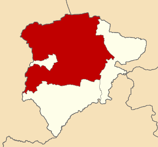
Rutland is a ceremonial county and unitary authority in the East Midlands, England. The county is bounded to the west and north by Leicestershire, to the northeast by Lincolnshire and the southeast by Northamptonshire.

<span class="mw-page-title-main">Cottesmore Hunt</span> Foxhound pack in Cottesmore, Britain

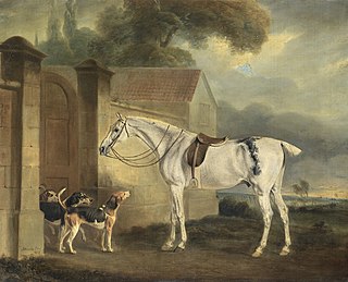
The Cottesmore Hunt, which hunts mostly in Rutland, is one of the oldest foxhound packs in Britain. Its name comes from the village of Cottesmore where the hounds were kennelled.

References

  1. The County of Leicestershire (District Wards) Order 1973
  2. legislation.gov.uk - The District of Rutland (Electoral Arrangements) Order 1977. Retrieved on 19 November 2015.
  3. legislation.gov.uk - The Leicestershire (City of Leicester and District of Rutland) (Structural Change) Order 1996. Retrieved on 6 November 2015.
  4. legislation.gov.uk - The District of Rutland (Electoral Changes) Order 2003. Retrieved on 3 November 2015.
  5. "The Rutland (Electoral Changes) Order 2018" . Retrieved 26 January 2020.