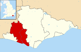
List of electoral wards in East Sussex

Last updated

This is a list of electoral divisions and wards in the ceremonial county of East Sussex in South East England. All changes since the re-organisation of local government following the passing of the Local Government Act 1972 are shown. The number of councillors elected for each electoral division or ward is shown in brackets.

Contents

County council

East Sussex

Electoral Divisions from 1 April 1974 (first election 12 April 1973) to 2 May 1985: [1] [2]

  1. Barcombe (1)
  2. Battle (1)
  3. Beckley (1)
  4. Bexhill (East) (1)
  5. Bexhill (North) (1)
  6. Bexhill (South) (1)
  7. Bexhill (West) (1)
  8. Brighton (Elm Grove) (1)
  9. Brighton (Falmer) (1)
  10. Brighton (Hanover) (1)
  11. Brighton (Hollingbury) (1)
  12. Brighton (Kings Cliff) (1)
  13. Brighton (Lewes Road) (1)
  14. Brighton (Montpelier) (1)
  15. Brighton (Moulscoomb) (1)
  16. Brighton (Patcham) (1)
  17. Brighton (Pier) (1)
  18. Brighton (Preston Park) (1)
  19. Brighton (Preston) (1)
  20. Brighton (Queens Park) (1)
  21. Brighton (Regency) (1)
  22. Brighton (Rottingdean) (1)
  23. Brighton (St Nicholas) (1)
  24. Brighton (St Peters) (1)
  25. Brighton (Stanmer) (2)
  26. Brighton (Warren) (2)
  27. Buxted & Mayfield (1)
  28. Crowborough (1)
  29. Cuckmere (1)
  30. Ditchling (1)
  31. Eastbourne No. 1 (1)
  32. Eastbourne No. 2 (Central) (1)
  33. Eastbourne No. 3 (Downside) (1)
  34. Eastbourne No. 4 (Hampden Park) (1)
  35. Eastbourne No. 5 (Langney) (1)
  36. Eastbourne No. 6 (Meads) (1)
  37. Eastbourne No. 7 (Ratton) (1)
  38. Eastbourne No. 8 (Roselands) (1)
  39. Eastbourne No. 9 (Upperton) (1)
  40. Forest Row (1)
  41. Hailsham (1)
  42. Hastings No. 1 (All Saints & St Cl (1)
  43. Hastings No. 2 (St Helens & St Mary in the C (2)
  44. Hastings No. 3 (Hollington) (1)
  45. Hastings No. 4 (Holy Trinity) (1)
  46. Hastings No. 5 (St Leonards) (1)
  47. Hastings No. 6 (St Mary-in-the-Cas (1)
  48. Hastings No. 7 (St Mary Magdalen) (1)
  49. Hastings No. 8 (St Peters) (1)
  50. Heathfield (1)
  51. Hellingly (1)
  52. Hove (Adelaide) (1)
  53. Hove (Brunswick) (1)
  54. Hove (Goldsmid) (1)
  55. Hove (Goldstone) (1)
  56. Hove (Hangleton) (1)
  57. Hove (Knoll) (1)
  58. Hove (Stanford) (1)
  59. Hove (Vallance) (1)
  60. Hove (Westbourne) (1)
  61. Hove (Wish) (1)
  62. Lewes (East) (1)
  63. Lewes (West) (1)
  64. Maresfield (1)
  65. Newhaven (1)
  66. Peacehaven (1)
  67. Pevensey (1)
  68. Polegate (1)
  69. Portslade (North) (1)
  70. Portslade (South) (1)
  71. Rye (1)
  72. Salehurst (1)
  73. Seaford (Blatchington) (1)
  74. Seaford (Sutton) (1)
  75. Telscombe (1)
  76. Ticehurst (1)
  77. Uckfield (1)
  78. Wadhurst (1)
  79. Willingdon (1)
  80. Winchelsea (1)
  81. Withyham (1)

Electoral Divisions from 2 May 1985 to 5 May 2005: [3] [2]

  1. Battle (1)
  2. Bexhill East (1)
  3. Bexhill North (1)
  4. Bexhill South (1)
  5. Bexhill West (1)
  6. Braybrooke & Castle (1)
  7. Broomgrove & Ore (1)
  8. Brunswick & Adelaide (1); electoral division abolished in 1997 [4]
  9. Buxted & Maresfield (1)
  10. Cavendish (1)
  11. Central St Leonards & Gensing (1)
  12. Chailey (1)
  13. College (1)
  14. Crowborough (Beacon) (1)
  15. Crowborough (Rothersfield) (1)
  16. Forest Row (1)
  17. Goldsmid (1); electoral division abolished in 1997 [4]
  18. Hailsham (1)
  19. Hangleton (1); electoral division abolished in 1997 [4]
  20. Hanover (1); electoral division abolished in 1997 [4]
  21. Heathfield (1)
  22. Hellingly (1)
  23. Hollingbury (1); electoral division abolished in 1997 [4]
  24. Hollington & Ashdown (1)
  25. Kings Cliff (1); electoral division abolished in 1997 [4]
  26. Lewes (1)
  27. Marine (1); electoral division abolished in 1997 [4]
  28. Moulsecoomb (1); electoral division abolished in 1997 [4]
  29. Nevill (1); electoral division abolished in 1997 [4]
  30. Newhaven (1)
  31. Old Hastings & Mount Pleasant (1)
  32. Old Town (1)
  33. Park (1)
  34. Patcham (1); electoral division abolished in 1997 [4]
  35. Peacehaven (1)
  36. Pevensey (1)
  37. Polegate (1)
  38. Portslade North (1); electoral division abolished in 1997 [4]
  39. Portslade South (1); electoral division abolished in 1997 [4]
  40. Preston (1); electoral division abolished in 1997 [4]
  41. Princes (1)
  42. Priory (1)
  43. Queens Park (1); electoral division abolished in 1997 [4]
  44. Regency (1); electoral division abolished in 1997 [4]
  45. Ringmer (1)
  46. Rottingdean (1); electoral division abolished in 1997 [4]
  47. Rye (1)
  48. Seaford (Blatchington) (1)
  49. Seaford (Sutton) (1)
  50. Seven Dials (1); electoral division abolished in 1997 [4]
  51. Silverhill & Wishing Tree (1)
  52. St Helens & Elphinstone (1)
  53. St Marys (1)
  54. St Peters (1); electoral division abolished in 1997 [4]
  55. Stanford (1); electoral division abolished in 1997 [4]
  56. Stanmer (1); electoral division abolished in 1997 [4]
  57. Telscombe (1)
  58. Tenantry (1); electoral division abolished in 1997 [4]
  59. Ticehurst (1)
  60. Uckfield (1)
  61. Vallance (1); electoral division abolished in 1997 [4]
  62. Wadhurst (1)
  63. West St Leonards & Maze Hill (1)
  64. Westbourne (1); electoral division abolished in 1997 [4]
  65. Westdene (1); electoral division abolished in 1997 [4]
  66. Willingdon (1)
  67. Winchelsea (1)
  68. Wish (1); electoral division abolished in 1997 [4]
  69. Woodingdean (1); electoral division abolished in 1997 [4]
  70. Woodlands (1)

Electoral Divisions from 5 May 2005 to 4 May 2017: [5]

East Sussex UK ward map (blank).svg
  1. Alfriston, East Hoathly & Hellingly (1) †
  2. Ashdown & Conquest (1)
  3. Baird & Ore (1)
  4. Battle & Crowhurst (1)
  5. Bexhill East (1)
  6. Bexhill King Offa (2)
  7. Bexhill West (1)
  8. Braybrooke & Castle (1)
  9. Brede Valley & Marsham (1)
  10. Buxted Maresfield (1) †
  11. Central St Leonards & Gensing (1)
  12. Chailey (1)
  13. Crowborough (2)
  14. Devonshire (1)
  15. Forest Row (1)
  16. Framfield & Horam (1)
  17. Hailsham & Herstmonceux (2) †
  18. Hampden Park (1)
  19. Heathfield (1)
  20. Hollington & Wishing Tree (1)
  21. Langney (1)
  22. Lewes (1)
  23. Maze Hill & West St Leonards (1)
  24. Meads (1)
  25. Newhaven & Ouse Valley West (1)
  26. Northern Rother (1)
  27. Old Hastings & Tressell (1)
  28. Old Town (1)
  29. Ouse Valley East (1)
  30. Peacehaven & Telscombe Towns (2)
  31. Pevensey & Westham (1) †
  32. Polegate, Willingdon & East Dean (2) †
  33. Ratton (1)
  34. Ringmer & Lewes Bridge (1)
  35. Rother North West (1)
  36. Rye & Eastern Rother (1)
  37. Seaford Blatchington (1)
  38. Seaford Sutton (1)
  39. Sovereign (1)
  40. St Anthony's (1)
  41. St Helens & Silverhill (1)
  42. Uckfield (1) †
  43. Upperton (1)
  44. Wadhurst (1)

† minor boundary changes in 2009 [6]

Electoral Divisions from 4 May 2017 to present: [7]

East Sussex UK electoral division map 2017 (blank).svg
  1. Arlington, East Hoathly & Hellingly (1)
  2. Ashdown & Conquest (1)
  3. Baird & Ore (1)
  4. Battle & Crowhurst (1)
  5. Bexhill East (1)
  6. Bexhill North (1)
  7. Bexhill South (1)
  8. Bexhill West (1)
  9. Braybrooke & Castle (1)
  10. Brede Valley & Marsham (1)
  11. Central St Leonards & Gensing (1)
  12. Chailey (1)
  13. Crowborough North & Jarvis Brook (1)
  14. Crowborough South & St Johns (1)
  15. Devonshire (1)
  16. Forest Row & Groombridge (1)
  17. Hailsham Market (1)
  18. Hailsham New Town (1)
  19. Hampden Park (1)
  20. Heathfield & Mayfield (1)
  21. Hollington & Wishing Tree (1)
  22. Langney (1)
  23. Lewes (1)
  24. Maresfield & Buxted (1)
  25. Maze Hill & West St Leonards (1)
  26. Meads (1)
  27. Newhaven & Bishopstone (1)
  28. Northern Rother (1)
  29. Old Hastings & Tressell (1)
  30. Old Town (1)
  31. Ouse Valley West & Downs (1)
  32. Peacehaven (1)
  33. Pevensey & Stone Cross (1)
  34. Polegate & Watermill (1)
  35. Ratton (1)
  36. Ringmer & Lewes Bridge (1)
  37. Rother North West (1)
  38. Rye & Eastern Rother (1)
  39. Seaford North (1)
  40. Seaford South (1)
  41. Sovereign (1)
  42. St Helens & Silverhill (1)
  43. St. Anthony's (1)
  44. Telscombe (1)
  45. Uckfield North (1)
  46. Uckfield South with Framfield (1)
  47. Upperton (1)
  48. Wealden East (1)
  49. Wealden North East (1)
  50. Willingdon & South Downs (1)

Unitary authority council

Brighton and Hove

Wards from 1 April 1997 (first election 2 May 1996) to 1 May 2003: [8] [9] [4]

  1. (3)
  2. (3)
  3. (3)
  4. (3)
  5. (3)
  6. (3)
  7. (3)
  8. (3)
  9. (3)
  10. (3)
  11. (3)
  12. (3)
  13. (3)
  14. (3)
  15. (3)
  16. (3)
  17. (3)
  18. (3)
  19. (3)
  20. (3)
  21. (3)
  22. (3)
  23. (3)
  24. (3)
  25. (3)
  26. (3)

Wards from 1 May 2003 to present: [10]

Brighton and Hove UK ward map (blank).svg
  1. Brunswick & Adelaide (2)
  2. Central Hove (2)
  3. East Brighton (3)
  4. Goldsmid (3)
  5. Hangleton & Knoll (3)
  6. Hanover & Elm Grove (3)
  7. Hollingbury & Stanmer (3); renamed Hollingdean & Stanmer in 2008 [11]
  8. Moulsecoomb & Bevendean (3)
  9. North Portslade (2)
  10. Patcham (3)
  11. Preston Park (3)
  12. Queen’s Park (3)
  13. Regency (2)
  14. Rottingdean Coastal (3)
  15. St Peter’s & North Laine (3)
  16. South Portslade (2)
  17. Stanford (2); renamed Hove Park in 2010 [12]
  18. Westbourne (2)
  19. Wish (2)
  20. Withdean (3)
  21. Woodingdean (2)

District councils

Eastbourne

Wards from 1 April 1974 (first election 7 June 1973) to 6 May 1976: [13]

Wards from 6 May 1976 to 2 May 2002: [14]

Wards from 2 May 2002 to present (boundary changes in 2019): [15] [16]

Eastbourne UK ward map 2010 (blank).svg
  1. Devonshire (3)
  2. Hampden Park (3)
  3. Langney (3)
  4. Meads (3)
  5. Old Town (3)
  6. Ratton (3)
  7. St Anthony's (3)
  8. Sovereign (3)
  9. Upperton (3)

Hastings

Wards from 1 April 1974 (first election 7 June 1973) to 3 May 1979: [13]

Wards from 3 May 1979 to 2 May 2002: [17]

Wards from 2 May 2002 to present (boundary changes in 2018): [18] [19]

Hastings UK ward map 2010 (blank).svg
  1. Ashdown (2)
  2. Baird (2)
  3. Braybrooke (2)
  4. Castle (2)
  5. Central St Leonards (2)
  6. Conquest (2)
  7. Gensing (2)
  8. Hollington (2)
  9. Maze Hill (2)
  10. Old Hastings (2)
  11. Ore (2)
  12. St Helens (2)
  13. Silverhill (2)
  14. Tressell (2)
  15. West St Leonards (2)
  16. Wishing Tree (2)

Lewes

Wards from 1 April 1974 (first election 7 June 1973) to 5 May 1983: [13]

Wards from 5 May 1983 to 1 May 2003: [20]

Wards from 1 May 2003 to 2 May 2019: [21]

Lewes UK ward map 2010 (blank).svg
  1. Barcombe & Hamsey (1)
  2. Chailey & Wivelsfield (2)
  3. Ditchling & Westmeston (1)
  4. East Saltdean & Telscombe Cliffs (3)
  5. Kingston (1)
  6. Lewes Bridge (2)
  7. Lewes Castle (2)
  8. Lewes Priory (3)
  9. Newhaven Denton & Meeching (3)
  10. Newhaven Valley (2)
  11. Newick (1)
  12. Ouse Valley & Ringmer (3)
  13. Peacehaven East (2)
  14. Peacehaven North (2)
  15. Peacehaven West (2)
  16. Plumpton, Streat, East Chiltington & St John (Without) (1)
  17. Seaford Central (2)
  18. Seaford East (2)
  19. Seaford North (2)
  20. Seaford South (2)
  21. Seaford West (2)

Wards from 2 May 2019 to present: [22]

  1. Chailey, Barcombe & Hamsey (2)
  2. Ditchling & Westmeston (1)
  3. East Saltdean & Telscombe Cliffs (3)
  4. Kingston (1)
  5. Lewes Bridge (2)
  6. Lewes Castle (2)
  7. Lewes Priory (3)
  8. Newhaven North (2)
  9. Newhaven South (3)
  10. Newick (1)
  11. Ouse Valley & Ringmer (3)
  12. Peacehaven East (2)
  13. Peacehaven North (2)
  14. Peacehaven West (2)
  15. Plumpton, Streat, East Chiltington & St John (1)
  16. Seaford Central (2)
  17. Seaford East (2)
  18. Seaford North (2)
  19. Seaford South (2)
  20. Seaford West (2)
  21. Wivelsfield (1)

Rother

Wards from 1 April 1974 (first election 7 June 1973) to 5 May 1983: [13]

Wards from 5 May 1983 to 1 May 2003: [23]

Wards from 1 May 2003 to 2 May 2019: [24]

Rother UK ward map 2010 (blank).svg
  1. Battle Town (2)
  2. Brede Valley (2)
  3. Central (2)
  4. Collington (2)
  5. Crowhurst (1)
  6. Darwell (2)
  7. Eastern Rother (2)
  8. Ewhurst & Sedlescombe (1)
  9. Kewhurst (2)
  10. Marsham (2)
  11. Old Town (2)
  12. Rother Levels (2)
  13. Rye (2)
  14. Sackville (2)
  15. St Marks (2)
  16. St Michaels (2)
  17. St Stephens (2)
  18. Salehurst (2)
  19. Sidley (2)
  20. Ticehurst & Etchingham (2)

Wards from 2 May 2019 to present: [25]

  1. Bexhill Central (2)
  2. Bexhill Collington (2)
  3. Bexhill Kewhurst (2)
  4. Bexhill Old Town & Worsham (2)
  5. Bexhill Pebsham & St Michaels (2)
  6. Bexhill Sackville (2)
  7. Bexhill Sidley (2)
  8. Bexhill St Marks (2)
  9. Bexhill St Stephens (2)
  10. Brede & Udimore (1)
  11. Burwash & the Weald (2)
  12. Catsfield & Crowhurst (1)
  13. Eastern Rother (2)
  14. Hurst Green & Ticehurst (2)
  15. North Battle, Netherfield & Whatlington (2)
  16. Northern Rother (2)
  17. Robertsbridge (1)
  18. Rye & Winchelsea (2)
  19. Sedlescombe & Westfield (2)
  20. South Battle & Telham (1)
  21. Southern Rother (2)

Wealden

Wards from 1 April 1974 (first election 7 June 1973) to 5 May 1983: [13]

Wards from 5 May 1983 to 1 May 2003: [26]

Wards from 1 May 2003 to 2 May 2019: [27]

Wealden UK ward map 2010 (blank).svg
  1. Alfriston (1) †
  2. Buxted & Maresfield (2) †
  3. Chiddingly & East Hoathly (1)
  4. Cross in Hand/Five Ashes (1)
  5. Crowborough East (2)
  6. Crowborough Jarvis Brook (1)
  7. Crowborough North (2)
  8. Crowborough St Johns (1)
  9. Crowborough West (2)
  10. Danehill/Fletching/Nutley (2)
  11. East Dean (1) †
  12. Forest Row (2)
  13. Framfield (1)
  14. Frant/Withyham (2) †
  15. Hailsham Central & North (2)
  16. Hailsham East (1)
  17. Hailsham South & West (3) †
  18. Hartfield (1)
  19. Heathfield East (1)
  20. Heathfield North & Central (3)
  21. Hellingly (2) †
  22. Herstmonceux (1)
  23. Horam (1)
  24. Mayfield (1)
  25. Ninfield & Hooe with Wartling (1)
  26. Pevensey & Westham (3) †
  27. Polegate North (2) †
  28. Polegate South (1) †
  29. Rotherfield (1)
  30. Uckfield Central (1)
  31. Uckfield New Town (1)
  32. Uckfield North (2) †
  33. Uckfield Ridgewood (1)
  34. Wadhurst (2) †
  35. Willingdon (3) †

† minor boundary changes in 2007 [6]

Wards from 2 May 2019 to present: [28]

  1. Arlington (1)
  2. Buxted (1)
  3. Chiddingly, East Hoathly & Waldron (1)
  4. Crowborough Central (1)
  5. Crowborough Jarvis Brook (1)
  6. Crowborough North (1)
  7. Crowborough South East (1)
  8. Crowborough South West (1)
  9. Crowborough St Johns (1)
  10. Danehill & Fletching (1)
  11. Forest Row (1)
  12. Framfield & Cross-in-Hand (1)
  13. Frant & Wadhurst (2)
  14. Hadlow Down & Rotherfield (1)
  15. Hailsham Central (1)
  16. Hailsham East (1)
  17. Hailsham North (1)
  18. Hailsham North West (1)
  19. Hailsham South (1)
  20. Hailsham West (1)
  21. Hartfield (1)
  22. Heathfield North (1)
  23. Heathfield South (1)
  24. Hellingly (1)
  25. Herstmonceux & Pevensey Levels (2)
  26. Horam & Punnetts Town (2)
  27. Lower Willingdon (1)
  28. Maresfield (1)
  29. Mayfield & Five Ashes (1)
  30. Pevensey Bay (1)
  31. Polegate Central (1)
  32. Polegate North (1)
  33. Polegate South & Willingdon Watermill (1)
  34. South Downs (1)
  35. Stone Cross (1)
  36. Uckfield East (1)
  37. Uckfield New Town (2)
  38. Uckfield North (1)
  39. Uckfield Ridgewood & Little Horsted (1)
  40. Upper Willingdon (1)
  41. Withyham (1)

Former district councils

Brighton

Wards from 1 April 1974 (first election 7 June 1973) to 5 May 1983: [13]

Wards from 5 May 1983 to 1 April 1997 (district abolished): [8]

Hove

Wards from 1 April 1974 (first election 7 June 1973) to 3 May 1979: [13]

Wards from 3 May 1979 to 1 April 1997 (district abolished): [9]

Electoral wards by constituency

Bexhill and Battle

Battle Town, Central, Collington, Cross In Hand/Five Ashes, Crowhurst, Darwell, Ewhurst and Sedlescombe, Heathfield East, Heathfield North and Central, Herstmonceux, Kewhurst, Ninfield and Hooe with Wartling, Old Town, Pevensey and Westham, Rother Levels, Sackville, St Marks, St Michaels, St Stephens, Salehurst, Sidley, Ticehurst and Etchingham.

Brighton, Kemptown

East Brighton, East Saltdean and Telscombe Cliffs, Moulsecoomb and Bevendean, Peacehaven East, Peacehaven North, Peacehaven West, Queen's Park, Rottingdean Coastal, Woodingdean.

Brighton, Pavilion

Hanover and Elm Grove, Hollingdean and Stanmer, Patcham, Preston Park, Regency, St Peter's and North Laine, Withdean.

Eastbourne

Devonshire, Hampden Park, Langney, Meads, Old Town, Ratton, St Anthony's, Sovereign, Upperton, Willingdon.

Hastings and Rye

Ashdown, Baird, Braybrooke, Brede Valley, Castle, Central St Leonards, Conquest, Eastern Rother, Gensing, Hollington, Marsham, Maze Hill, Old Hastings, Ore, Rye, St Helens, Silverhill, Tressell, West St Leonards, Wishing Tree.

Hove

Brunswick and Adelaide, Central Hove, Goldsmid, Hangleton and Knoll, Hove Park, North Portslade, South Portslade, Westbourne, Wish.

Lewes

Alfriston, Barcombe and Hamsey, Chailey and Wivelsfield, Ditchling and Westmeston, East Dean, Kingston, Lewes Bridge, Lewes Castle, Lewes Priory, Newhaven Denton and Meeching, Newhaven Valley, Newick, Ouse Valley and Ringmer, Plumpton, Streat, East Chiltington and St John (Without), Polegate North, Polegate South, Seaford Central, Seaford East, Seaford North, Seaford South, Seaford West.

Wealden

Buxted and Maresfield, Chiddingly and East Hoathly, Crowborough East, Crowborough Jarvis Brook, Crowborough North, Crowborough St. Johns, Crowborough West, Danehill/Fletching/Nutley, Forest Row, Framfield, Frant/Withyham, Hailsham Central and North, Hailsham East, Hailsham South and West, Hartfield, Hellingly, Horam, Mayfield, Rotherfield, Uckfield Central, Uckfield New Town, Uckfield North, Uckfield Ridgewood, Wadhurst.

See also

Related Research Articles

<span class="mw-page-title-main">East Sussex</span> County of England

East Sussex is a ceremonial county in South East England. Established in 1974 from the eastern half of Sussex, it is bordered by Kent to the north-east, West Sussex to the west, Surrey to the north-west, and the English Channel to the south. The largest settlement is the city of Brighton and Hove.

<span class="mw-page-title-main">Wealden District</span> District in East Sussex, England

<span class="mw-page-title-main">Lewes District</span> Non-metropolitan district in England

Lewes is a local government district in East Sussex, England. The district is named after the town of Lewes, where the council is based, although the largest town is Seaford. The district also includes the towns of Newhaven, Peacehaven and Telscombe and numerous villages and surrounding rural areas.

<span class="mw-page-title-main">Polegate</span> Town in East Sussex, England

Polegate is a town and civil parish in the Wealden District of East Sussex, England, United Kingdom. It is located five miles (8 km) north of the seaside resort of Eastbourne and is part of the greater area of that town. Although once a railway settlement, its rail links were closed as part of the Beeching cuts. The 2011 census put the civil parish of Polegate at a population of 8,586, with 41.2% aged 65 and over.

<span class="mw-page-title-main">East Coastway line</span> Railway line in Sussex, England

The East Coastway line is a railway line along the south coast of Sussex to the east of Brighton, England. Trains to the west of Brighton operate on the West Coastway line. Together with the West Coastway and the Marshlink line to the east, the line forms part of a continuous route from Havant to Ashford. The Brighton Main Line route to Eastbourne and Hastings, via Plumpton and Cooksbridge, shares the East Coastway line east of Lewes station.

<span class="mw-page-title-main">Lewes (UK Parliament constituency)</span> Parliamentary constituency in the United Kingdom, 1868 onwards

Lewes is a constituency in East Sussex represented in the House of Commons of the UK Parliament since 2015 by Maria Caulfield, a Conservative.

<span class="mw-page-title-main">Wealden (UK Parliament constituency)</span>

Wealden is a constituency represented in the House of Commons of the UK Parliament since 2015 by Nus Ghani, a Conservative. Ghani is the first Muslim woman to be elected as a Conservative member of Parliament.

<span class="mw-page-title-main">Southdown Motor Services</span>

Southdown Motors Services Ltd was a bus and coach operator in East and West Sussex and parts of Hampshire, in southern England. It was formed in 1915 and had various owners throughout its history, being purchased by the National Bus Company (NBC) in 1969. The company fleet name was lost when it was acquired by the Stagecoach Group in 1989 but buses operated under that legal name until 2015 when the operating licence was transferred to another company within the Stagecoach Group and 1915 company became dormant but still owned by the Stagecoach Group.

The BN postcode area, also known as the Brighton postcode area, is a group of 30 postcode districts in South East England, within 18 post towns. These cover southwestern East Sussex and southeastern West Sussex. The main sorting office is at the Gatwick Mail Centre in Crawley.

Sussex 1 is an English level 9 Rugby Union League. It is made up of teams predominantly from Sussex. Teams play home and away matches from September through to April. The league champions are automatically promoted up to London 3 South East, while the second placed team plays a promotion playoff against the second placed team from Kent 1. Relegated teams drop to Sussex 2 although in recent season there has been no relegation. Only 1st XV sides can be promoted into London 3 South East.

<span class="mw-page-title-main">Sussex Rugby Football Union</span> Rugby team

The Sussex Rugby Football Union is the society responsible for rugby union in the county of Sussex, England and is one of the constituent bodies of the national Rugby Football Union.

<span class="mw-page-title-main">Brighton & Hove Bus Regency Route</span>

The Regency Route is a name given since 1977 to a regular bus service between Brighton in East Sussex and Tunbridge Wells in Kent, both towns with a Regency heritage. The route runs via the East Sussex towns of Lewes, Uckfield and Crowborough.

Healthcare in Sussex was the responsibility of seven Clinical Commissioning Groups covering: Brighton and Hove; Coastal West Sussex; Horsham and Mid Sussex; Crawley; Eastbourne Hailsham and Seaford; Hastings and Rother; High Weald; and Lewes-Havens from 2013 to 2020. From April 2020 they were merged into three covering East Sussex, West Sussex, and Brighton and Hove. In 2021 the three Sussex CCGs were merged into one, Sussex CCG. In 2022 Sussex CCG transitioned into an Integrated Care Board or ICB.

The 2019–20 Southern Combination Football League season was the 95th in the history of the competition, which lies at levels 9 and 10 of the English football league system.

The 2022–23 Southern Combination Football League season was the 98th in the history of the competition, which lies at levels 9, 10 and 11 of the English football league system.

References

  1. The County of East Sussex (Electoral Divisions) Order 1973
  2. 1 2 Rallings, Colin; Thrasher, Michael. East Sussex County Council Election Results 1973-2009 (PDF). The Elections Centre. Retrieved 12 May 2016.
  3. legislation.gov.uk - The County of East Sussex (Electoral Arrangements) Order 1982. Retrieved on 19 November 2015.
  4. 1 2 3 4 5 6 7 8 9 10 11 12 13 14 15 16 17 18 19 20 21 22 23 24 25 26 27 legislation.gov.uk - The East Sussex (Boroughs of Brighton and Hove) (Structural Change) Order 1995. Retrieved on 6 November 2015.
  5. legislation.gov.uk - The County of East Sussex (Electoral Changes) Order 2004. Retrieved on 3 November 2015.
  6. 1 2 legislation.gov.uk - The Wealden (Parish Electoral Arrangements and Electoral Changes) Order 2007. Retrieved on 3 November 2015.
  7. "The East Sussex (Electoral Changes) Order 2016". gov.uk . 13 December 2016. Retrieved 19 April 2022.
  8. 1 2 The Borough of Brighton (Electoral Arrangements) Order 1980
  9. 1 2 legislation.gov.uk - The Borough of Hove (Electoral Arrangements) Order 1978. Retrieved on 19 November 2015.
  10. legislation.gov.uk - The City of Brighton and Hove (Electoral Changes) Order 2001. Retrieved on 4 October 2015.
  11. Brighton & Hove City Council letter dated 4 December 2008
  12. Brighton & Hove City Council letter dated 28 February 2010
  13. 1 2 3 4 5 6 7 The County of East Sussex (District Wards) Order 1973
  14. The Borough of Eastbourne (Electoral Arrangements) Order 1975
  15. legislation.gov.uk - The Borough of Eastbourne (Electoral Changes) Order 2001. Retrieved on 4 October 2015.
  16. "The Eastbourne (Electoral Changes) Order 2016". gov.uk . 15 December 2016. Retrieved 6 April 2022.
  17. legislation.gov.uk - The Borough of Hastings (Electoral Arrangements) Order 1978. Retrieved on 19 November 2015.
  18. legislation.gov.uk - The Borough of Hastings (Electoral Changes) Order 2001. Retrieved on 4 October 2015.
  19. "The Hastings (Electoral Changes) Order 2016". gov.uk . 15 December 2016. Retrieved 20 April 2022.
  20. legislation.gov.uk - The District of Lewes (Electoral Arrangements) Order 1979. Retrieved on 19 November 2015.
  21. legislation.gov.uk - The District of Lewes (Electoral Changes) Order 2001. Retrieved on 4 October 2015.
  22. "The Lewes (Electoral Changes) Order 2016". gov.uk . 15 December 2016. Retrieved 6 April 2022.
  23. The District of Rother (Electoral Arrangements) Order 1980
  24. legislation.gov.uk - The District of Rother (Electoral Changes) Order 2001. Retrieved on 4 October 2015.
  25. "The Rother (Electoral Changes) Order 2016". gov.uk . 15 December 2016. Retrieved 6 April 2022.
  26. legislation.gov.uk - The District of Wealden (Electoral Arrangements) Order 1979. Retrieved on 19 November 2015.
  27. legislation.gov.uk - The District of Wealden (Electoral Changes) Order 2001. Retrieved on 4 October 2015.
  28. "The Wealden (Electoral Changes) Order 2016". gov.uk . 15 December 2016. Retrieved 6 April 2022.