List of electoral wards in Merseyside

Last updated

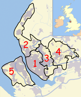
This is a list of electoral divisions and wards in the ceremonial county of Merseyside in North West England. All changes since the re-organisation of local government following the passing of the Local Government Act 1972 are shown. The number of councillors elected for each electoral division or ward is shown in brackets.

Contents

District councils

Knowsley

Wards from 1 April 1974 (first election 10 May 1973) to 6 May 1982: [1]

  1. No. 1 (Huyton: Huyton Farm-Princess-Woolfall) (6)
  2. No. 2 (Huyton: Longview and Rupert Farm) (3)
  3. No. 3 (Huyton: St. Agnes-St. Bartholomew-Swanside) (6)
  4. No. 4 (Huyton: St. Gabriels and St. Michaels) (6)
  5. No. 5 (Kirkby:Central) (3)
  6. No. 6 (Kirkby: Cherryfield) (3)
  7. No. 7 (Kirkby: Minstead) (3)
  8. No. 8 (Kirkby: Northwood and Tower Hill) (3)
  9. No. 9 (Kirkby: Park) (3)
  10. No. 10 (Whitefield) (3)
  11. No. 11 (Prescot) (6)
  12. No. 12 (Whiston) (6)
  13. No. 13 (Halewood) (6)
  14. No. 14 (Knowsley) (6)

Wards from 6 May 1982 to 10 June 2004: [2]

  1. Cantril Farm (3)
  2. Cherryfield (3)
  3. Halewood East (3)
  4. Halewood South (3)
  5. Halewood West (3)
  6. Kirkby Central (3)
  7. Knowsley Park (3)
  8. Longview (3)
  9. Northwood (3)
  10. Page Moss (3)
  11. Park (3)
  12. Prescot East (3)
  13. Prescot West (3)
  14. Princess (3)
  15. Roby (3)
  16. St. Gabriels (3)
  17. St. Michaels (3)
  18. Swanside (3)
  19. Tower Hill (3)
  20. Whiston North (3)
  21. Whiston South (3)
  22. Whitefield (3)

Wards from 10 June 2004 to 5 May 2016: [3]

Knowsley UK ward map 2010 (blank).svg
  1. Cherryfield (3)
  2. Halewood North (3)
  3. Halewood South (3)
  4. Halewood West (3)
  5. Kirkby Central (3)
  6. Longview (3)
  7. Northwood (3)
  8. Page Moss (3)
  9. Park (3)
  10. Prescot East (3)
  11. Prescot West (3)
  12. Roby (3)
  13. St Bartholomews (3)
  14. St Gabriels (3)
  15. St Michaels (3)
  16. Shevington (3)
  17. Stockbridge (3)
  18. Swanside (3)
  19. Whiston North (3)
  20. Whiston South (3)
  21. Whitefield (3)

Wards from 5 May 2016 to present: [4]

Knowsley UK ward map 2016 (blank).svg
  1. Cherryfield (3)
  2. Halewood North (3)
  3. Halewood South (3)
  4. Northwood (3)
  5. Page Moss (3)
  6. Prescot North (3)
  7. Prescot South (3)
  8. Roby (3)
  9. Shevington (3)
  10. St Gabriels (3)
  11. St Michaels (3)
  12. Stockbridge (3)
  13. Swanside (3)
  14. Whiston and Cronton (3)
  15. Whitefield (3)

Liverpool

Wards from 1 November 1835 (First election 26 December 1835) to 31 October 1895: [5]

  1. Everton and Kirkdale (3)
  2. Scotland (3)
  3. Vauxhall (3)
  4. St. Paul's (3)
  5. Exchange (3)
  6. Castle Street (3)
  7. St. Peter's (3)
  8. Pitt Street (3)
  9. Great George (3)
  10. Rodney Street (3)
  11. Aberctomby (3)
  12. Lime Street (3)
  13. St. Anne Street(3)
  14. West Derby (3)
  15. South Toxteth (3)
  16. North Toxteth (3)

Wards from 1 November 1895 (first election 1 November 1895) to 30 April 1953:

  1. Sandhills (3)
  2. Kirkdale (3)
  3. South Walton (3)
  4. Fairfield (3)
  5. Wavertree (3)
  6. Breckfield (3)
  7. St. Domingo (3)
  8. Netherfield (3)
  9. Everton (3)
  10. Low Hill (3)
  11. Kensington (3)
  12. Edge Hill (3)
  13. North Scotland (3)
  14. South Scotland (3)
  15. Vauxhall (3)
  16. Exchange (3)
  17. St. Anne's (3)
  18. Castle Street (3)
  19. St. Peter's (3)
  20. Great George (3)
  21. Abercromby (3)
  22. Granby (3)
  23. Prince's Park (3)
  24. Sefton Park (3)
  25. Brunswick (3)
  26. Dingle (3)
  27. North Walton (3)
  28. West Derby (3)

1913 Two new wards created : Much Woolton and Allerton, Childwall and Little Woolton

1920 Allerton, Childwall and Little Woolton ward split into Allerton (1 seat); Childwall (2 seats) and Little Woolton (1 seat)

1924 Second seat added for Allerton ward.

1925 Third seat added for Allerton ward

1928 Third seat added for Childwall ward. Croxteth ward added.

Wards from 1 May 1953 (first election 1 May 1953) to 30 April 1973:

  1. Abercromby (3)
  2. Aigburth (3)
  3. Allerton (3)
  4. Anfield (3)
  5. Arundel (3)
  6. Breckfield (3)
  7. Broadgreen (3)
  8. Central (3)
  9. Childwall (3)
  10. Church (3)
  11. Clubmoor (3)
  12. County (3)
  13. Croxteth (3)
  14. Dingle (3)
  15. Dovecot (3)
  16. Everton (3)
  17. Fairfield (3)
  18. Fazakerley (3)
  19. Gillmoss (3)
  20. Granby (3)
  21. Kensington (3)
  22. Low Hill (3)
  23. Melrose (3)
  24. Netherfield (3)
  25. Old Swan (3)
  26. Picton (3)
  27. Pirrie (3)
  28. Princes Park (3)
  29. Sandhills (3)
  30. St. Domingo (3)
  31. St. James' (3)
  32. St. Mary's (3)
  33. St. Michael's (3)
  34. Smithdown (3)
  35. Speke (3)
  36. Tuebrook (3)
  37. Vauxhall (3)
  38. Warbreck (3)
  39. Westminster (3)
  40. Woolton (3)

Wards from 1 April 1974 (first election 10 May 1973) to 1 May 1980: [1]

  1. Abercromby / St. James (3)
  2. Aigburth (3)
  3. Allerton (3)
  4. Anfield (3)
  5. Arundel (3)
  6. Breckfield / St. Domingo (3)
  7. Broadgreen (3)
  8. Central / Everton / Netherfield (3)
  9. Childwall (3)
  10. Church (3)
  11. Clubmoor (3)
  12. County (3)
  13. Croxteth (3)
  14. Dingle (3)
  15. Dovecot (3)
  16. Fairfield (3)
  17. Fazakerley (3)
  18. Gillmoss (3)
  19. Granby / Princes Park (3)
  20. Kensington (3)
  21. Low Hill / Smithdown (3)
  22. Melrose / Westminster (3)
  23. Old Swan (3)
  24. Picton (3)
  25. Pirrie (3)
  26. Sandhills / Vauxhall (3)
  27. St. Mary's (3)
  28. St. Michael's (3)
  29. Speke (3)
  30. Tuebrook (3)
  31. Warbreck (3)
  32. Woolton East (3)
  33. Woolton West (3)

Wards from 1 May 1980 to 10 June 2004: [6]

  1. Abercromby (3)
  2. Aigburth (3)
  3. Allerton (3)
  4. Anfield (3)
  5. Arundel (3)
  6. Breckfield (3)
  7. Broadgreen (3)
  8. Childwall (3)
  9. Church (3)
  10. Clubmoor (3)
  11. County (3)
  12. Croxteth (3)
  13. Dingle (3)
  14. Dovecot (3)
  15. Everton (3)
  16. Fazakerley (3)
  17. Gillmoss (3)
  18. Granby (3)
  19. Grassendale (3)
  20. Kensington (3)
  21. Melrose (3)
  22. Netherley (3)
  23. Old Swan (3)
  24. Picton (3)
  25. Pirrie (3)
  26. St. Mary's (3)
  27. Smithdown (3)
  28. Speke (3)
  29. Tuebrook (3)
  30. Valley (3)
  31. Vauxhall (3)
  32. Warbreck (3)
  33. Woolton (3)

Wards from 10 June 2004 to 3 May 2023: [7]

Liverpool UK ward map 2010 (blank).svg

Wards from 4 May 2023 to present: [8]

LiverpoolCity Council Ward Map 2023 (blank).svg

Sefton

Wards from 1 April 1974 (first election 10 May 1973) to 3 May 1979: [1]

  1. No. 1 (Bootle: Derby and Stanley) (3)
  2. No. 2 (Bootle: Linacre and Mersey) (3)
  3. No. 3 (Bootle: Netherton) (3)
  4. No. 4 (Bootle: Orrell) (3)
  5. No. 5 (Bootle: Sefton) (3)
  6. No. 6 (Southport: Ainsdale and Birkdale South) (6)
  7. No. 7 (Southport: Birkdale East and North and South) (3)
  8. No. 8 (Southport: Central-Birkdale West-West) (3)
  9. No. 9 (Southport: Craven-Sussex-Talbot) (3)
  10. No. 10 (Southport: Hesketh and Scarisbrick) (3)
  11. No. 11 (Southport: Marine and Park) (3)
  12. No. 12 (Crosby: Central-College-St. Johns) (3)
  13. No. 13 (Crosby: Christchurch-St. Marys-St. Thomas) (3)
  14. No. 14 (Crosby: East) (3)
  15. No. 15 (Crosby: North and West) (3)
  16. No. 16 (Formby: Duke Street and Raven Meols) (3)
  17. No. 17 (Formby: Freshfield-Oldtown-St. Lukes) (3)
  18. No. 18 (Litherland: Beach-Ford-Hatton Hill) (3)
  19. No. 19 (Litherland: Church-Hornby-Osborne-Walker) (3)
  20. No. 20 (Aintree) (3)
  21. No. 21 (Maghull East and North Melling) (3)
  22. No. 22 (Maghull South and West Melling) (3)

Wards from 3 May 1979 to 4 May 2000: [9]

  1. Ainsdale (3)
  2. Birkdale (3)
  3. Blundellsands (3)
  4. Cambridge (3)
  5. Church (3)
  6. Derby (3)
  7. Duke's (3)
  8. Ford (3)
  9. Harington (3)
  10. Kew (3)
  11. Linacre (3)
  12. Litherland (3)
  13. Manor (3)
  14. Meols (3)
  15. Molyneux (3)
  16. Netherton (3)
  17. Norwood (3)
  18. Orrell (3)
  19. Park (3)
  20. Ravenmeols (3)
  21. St. Oswald (3)
  22. Sudell (3)
  23. Victoria (3)

Wards from 4 May 2000 to 10 June 2004: [10]

  1. Ainsdale (3)
  2. Birkdale (3)
  3. Blundellsands (3)
  4. Cambridge (3)
  5. Church (3)
  6. Derby (3)
  7. Dukes (3)
  8. Ford (3)
  9. Harington (3)
  10. Kew (3)
  11. Linacre (3)
  12. Litherland (3)
  13. Manor (3)
  14. Meols (3)
  15. Molyneux (3)
  16. Netherton and Orrell (3)
  17. Norwood (3)
  18. Park (3)
  19. Ravenmeols (3)
  20. St Oswald (3)
  21. Sudell (3)
  22. Victoria (3)

Wards from 10 June 2004 to present: [11]

Sefton UK ward map 2010 (blank).svg
  1. Ainsdale (3)
  2. Birkdale (3)
  3. Blundellsands (3)
  4. Cambridge (3)
  5. Church (3)
  6. Derby (3)
  7. Duke's (3)
  8. Ford (3)
  9. Harington (3)
  10. Kew (3)
  11. Linacre (3)
  12. Litherland (3)
  13. Manor (3)
  14. Meols (3)
  15. Molyneux (3)
  16. Netherton and Orrell (3)
  17. Norwood (3)
  18. Park (3)
  19. Ravenmeols (3)
  20. St Oswald (3)
  21. Sudell (3)
  22. Victoria (3)

St Helens

Wards from 1 April 1974 (first election 10 May 1973) to 1 May 1980: [1]

  1. No. 1 (St. Helens: Central and South Eccleston) (3)
  2. No. 2 (St. Helens: East Sutton) (3)
  3. No. 3 (St. Helens: Hardshaw and Parr) (6)
  4. No. 4 (St. Helens: Moss Bank) (3)
  5. No. 5 (St. Helens: North Eccleston and South Windle) (3)
  6. No. 6 (St. Helens: North Windle) (3)
  7. No. 7 (St. Helens: West Sutton) (3)
  8. No. 8 (Haydock) (3)
  9. No. 9 (Newton-Le-Willows: Crow Lane-Town Hall-Viaduct) (3)
  10. No. 10 (Newton-le-Willows: Newton and Wargrave) (3)
  11. Billinge and Seneley Green (3)
  12. Rainford (3)
  13. No. 13 (Eccleston and Windle) (3)
  14. No. 14 (Rainhill and Bold) (3)

Wards from 1 May 1980 to 10 June 2004: [12]

  1. Billinge and Seneley Green (3)
  2. Blackbrook (3)
  3. Broad Oak (3)
  4. Eccleston (3)
  5. Grange Park (3)
  6. Haydock (3)
  7. Marshalls Cross (3)
  8. Moss Bank (3)
  9. Newton East (3)
  10. Newton West (3)
  11. Parr and Hardshaw (3)
  12. Queen's Park (3)
  13. Rainford (3)
  14. Rainhill (3)
  15. Sutton and Bold (3)
  16. Thatto Heath (3)
  17. West Sutton (3)
  18. Windle (3)

Wards from 10 June 2004 to 5 May 2022: [13]

St Helens UK ward map 2010 (blank).svg
  1. Billinge and Seneley Green (3)
  2. Blackbrook (3)
  3. Bold (3)
  4. Earlestown (3)
  5. Eccleston (3)
  6. Haydock (3)
  7. Moss Bank (3)
  8. Newton (3)
  9. Parr (3)
  10. Rainford (3)
  11. Rainhill (3)
  12. Sutton (3)
  13. Thatto Heath (3)
  14. Town Centre (3)
  15. West Park (3)
  16. Windle (3)

Wards from 5 May 2022: [14]

  1. Billinge & Seneley Green (3)
  2. Blackbrook (3)
  3. Bold & Lea Green (3)
  4. Eccleston (3)
  5. Haydock (3)
  6. Moss Bank (3)
  7. Newton-le-Willows East (3)
  8. Newton-le-Willows West (3)
  9. Parr (3)
  10. Peasley Cross & Fingerpost (1)
  11. Rainford (2)
  12. Rainhill (3)
  13. Sutton North West (2)
  14. Sutton South East (2)
  15. Thatto Heath (3)
  16. St Helens Town Centre (2)
  17. West Park (3)
  18. Windle (3)

Wirral

Wards from 1 April 1974 (first election 10 May 1973) to 1 May 1980: [1]

  1. No. 1 (Birkenhead: Argyle-Clifton-Holt) (3)
  2. No. 2 (Birkenhead: Bebington and Mersey) (3)
  3. No. 3 (Birkenhead: Cathcart-Claughton-Cleveland) (3)
  4. No. 4 (Birkenhead: Devonshire and Egerton) (3)
  5. No. 5 (Birkenhead: Gilbrook and St. James) (3)
  6. No. 6 (Birkenhead: Grange and Oxton) (3)
  7. No. 7 (Birkenhead: Prenton) (3)
  8. No. 8 (Birkenhead: Upton) (3)
  9. No. 9 (Wallasey: Leasowe) (3)
  10. No. 10 (Wallasey: Marlowe-Egremont-South Liscard) (3)
  11. No. 11 (Wallasey: Moreton and Saughall Massie) (3)
  12. No. 12 (Wallasey: New Brighton-Wallasey-Warren) (3)
  13. No. 13 (Wallasey: North Liscard-Upper Brighton-St. Hilary) (3)
  14. No. 14 (Wallasey: Seacombe-Poulton-Somerville) (3)
  15. No. 15 (Bebington: Higher Bebington and Woodhey) (3)
  16. No. 16 (Bebington: Park-New Ferry-North Bromborough) (3)
  17. No. 17 (Bebington: South Bromborough and Eastham) (3)
  18. No. 18 (Bebington: Lower Bebington and Poulton) (3)
  19. No. 19 (Hoylake: Caldy and Frankby) (3)
  20. No. 20 (Hoylake: Central-Hoose-Meols-Park) (3)
  21. No. 21 (Wirral: Barnston-Gayton-Heswall-Oldfield) (3)
  22. No. 22 (Wirral: Irby-Pensby-Thurstaston) (3)

Wards from 1 May 1980 to 10 June 2004: [15]

  1. Bebington (3)
  2. Bidston (3)
  3. Birkenhead (3)
  4. Bromborough (3)
  5. Clatterbridge (3)
  6. Claughton (3)
  7. Eastham (3)
  8. Egerton (3)
  9. Heswall (3)
  10. Hoylake (3)
  11. Leasowe (3)
  12. Liscard (3)
  13. Moreton (3)
  14. New Brighton (3)
  15. Oxton (3)
  16. Prenton (3)
  17. Royden (3)
  18. Seacombe (3)
  19. Thurstaston (3)
  20. Tranmere (3)
  21. Upton (3)
  22. Wallasey (3)

Wards from 10 June 2004 to present: [16]

Wirral UK ward map 2010 (blank).svg
  1. Bebington (3)
  2. Bidston and St James (3)
  3. Birkenhead and Tranmere (3)
  4. Bromborough (3)
  5. Clatterbridge (3)
  6. Claughton (3)
  7. Eastham (3)
  8. Greasby, Frankby and Irby (3)
  9. Heswall (3)
  10. Hoylake and Meols (3)
  11. Leasowe and Moreton East (3)
  12. Liscard (3)
  13. Moreton West and Saughall Massie (3)
  14. New Brighton (3)
  15. Oxton (3)
  16. Pensby and Thingwall (3)
  17. Prenton (3)
  18. Rock Ferry (3)
  19. Seacombe (3)
  20. Upton (3)
  21. Wallasey (3)
  22. West Kirby and Thurstaston (3)

Former county council

Merseyside

Electoral Divisions from 1 April 1974 (first election 12 April 1973) to 1 April 1986 (county council abolished): [1] [17] [18]

  1. Bebington No. 1 (1)
  2. Bebington No. 2 (1)
  3. Bebington No. 3 (1)
  4. Bebington No. 4 (1)
  5. Birkenhead No. 1 (1)
  6. Birkenhead No. 2 (1)
  7. Birkenhead No. 3 (1)
  8. Birkenhead No. 4 (1)
  9. Birkenhead No. 5 (1)
  10. Birkenhead No. 6 (1)
  11. Birkenhead No. 7 (Prenton) (1)
  12. Birkenhead No. 8 (Upton) (1)
  13. Bootle No. 1 (1)
  14. Bootle No. 2 (1)
  15. Bootle No. 3 (2)
  16. Crosby No. 1 (1)
  17. Crosby No. 2 (1)
  18. Crosby No. 3 (1)
  19. Crosby No. 4 (1)
  20. Formby (1)
  21. Haydock (1)
  22. Hoylake No. 1 (1)
  23. Hoylake No. 2 (1)
  24. Huyton with Roby No. 1 (1)
  25. Huyton with Roby No. 2 (1)
  26. Huyton with Roby No. 3 (1)
  27. Huyton with Roby No. 4 (1)
  28. Kirkby No. 1 (1)
  29. Kirkby No. 2 (1)
  30. Kirkby No. 3 (1)
  31. Litherland (1)
  32. Liverpool No. 1 (Abercromby/St James) (1)
  33. Liverpool No. 2 (Aigburth) (1)
  34. Liverpool No. 3 (Allerton) (1)
  35. Liverpool No. 4 (Anfield) (1)
  36. Liverpool No. 5 (Arundel) (1)
  37. Liverpool No. 6 (Breckfield/St Domingo) (1)
  38. Liverpool No. 7 (Broadgreen) (1)
  39. Liverpool No. 8 (Central/Everton/Netherfield) (1)
  40. Liverpool No. 9 (Childwall) (2)
  41. Liverpool No. 10 (Church) (1)
  42. Liverpool No. 11 (Clubmoor) (1)
  43. Liverpool No. 12 (County) (1)
  44. Liverpool No. 13 (Croxteth) (1)
  45. Liverpool No. 14 (Dingle) (1)
  46. Liverpool No. 15 (Dovecot) (1)
  47. Liverpool No. 16 (Fairfield) (1)
  48. Liverpool No. 17 (Fazakerley) (1)
  49. Liverpool No. 18 (Gillmoss) (2)
  50. Liverpool No. 19 (Granby/Princes Park) (1)
  51. Liverpool No. 20 (Kensington) (1)
  52. Liverpool No. 21 (Low Hill/Smithdown) (1)
  53. Liverpool No. 22 (Melrose/Westminster) (1)
  54. Liverpool No. 23 (Old Swan) (1)
  55. Liverpool No. 24 (Picton) (1)
  56. Liverpool No. 25 (Pirrie) (1)
  57. Liverpool No. 26 (St Marys) (1)
  58. Liverpool No. 27 (St Michaels) (1)
  59. Liverpool No. 28 (Sandhills/Vauxhall) (1)
  60. Liverpool No. 29 (Speke) (1)
  61. Liverpool No. 30 (Tuebrook) (1)
  62. Liverpool No. 31 (Warbreck) (1)
  63. Liverpool No. 32 (Woolton East) (1)
  64. Liverpool No. 33 (Woolton West) (2)
  65. Newton-le-Willows (1)
  66. Prescot (1)
  67. Rainford (1)
  68. Southport No. 1 (1)
  69. Southport No. 2 (1)
  70. Southport No. 3 (1)
  71. Southport No. 4 (1)
  72. Southport No. 5 (1)
  73. Southport No. 6 (1)
  74. St Helens No. 1 (1)
  75. St Helens No. 2 (East Sutton) (1)
  76. St Helens No. 3 (1)
  77. St Helens No. 4 (1)
  78. St Helens No. 5 (1)
  79. St Helens No. 6 (Parr) (1)
  80. Wallasey No. 1 (Leasowe) (1)
  81. Wallasey No. 2 (1)
  82. Wallasey No. 3 (1)
  83. Wallasey No. 4 (1)
  84. Wallasey No. 5 (1)
  85. Wallasey No. 6 (1)
  86. West Lancashire No. 1 (1)
  87. West Lancashire No. 2 (1)
  88. West Lancashire No. 3 (1)
  89. Whiston No. 1 (1)
  90. Whiston No. 2 (1)
  91. Whiston No. 3 (Halewood) (1)
  92. Whiston No. 4 (Knowsley) (1)
  93. Whiston No. 5 (1)
  94. Wirral No. 1 (1)
  95. Wirral No. 2 (1)

Electoral Divisions due from 2 May 1985 (order revoked by the Local Government Act 1985): [19]

  1. Abercromby (1)
  2. Aigburth (1)
  3. Ainsdale (1)
  4. Aintree (1)
  5. Allerton (1)
  6. Alt (1)
  7. Anfield (1)
  8. Arundel (1)
  9. Beacon (1)
  10. Bebington (1)
  11. Bidston (1)
  12. Birkdale (1)
  13. Birkenhead (1)
  14. Breckfield (1)
  15. Broadgreen (1)
  16. Bromborough (1)
  17. Buckley Hill (1)
  18. Childwall (1)
  19. Church (1)
  20. Clatterbridge (1)
  21. Claughton (1)
  22. Clubmoor (1)
  23. County (1)
  24. Crosby North (1)
  25. Crosby South (1)
  26. Crossens (1)
  27. Croxteth (1)
  28. Dingle (1)
  29. Dovecot (1)
  30. Eastham (1)
  31. Eccleston Mere (1)
  32. Egerton (1)
  33. Everton (1)
  34. Fazakerley (1)
  35. Fernhill (1)
  36. Freshfield (1)
  37. Gerard's Bridge (1)
  38. Gillmoss (1)
  39. Granby (1)
  40. Grassendale (1)
  41. Halewood Southwest (1)
  42. Hawthorne (1)
  43. Haydock Park (1)
  44. Hesketh (1)
  45. Heswall (1)
  46. Hoylake (1)
  47. Huyton East (1)
  48. Huyton South (1)
  49. Huyton West (1)
  50. Kensington (1)
  51. Knowsley Parish (1)
  52. Leasowe (1)
  53. Liscard (1)
  54. Marine (1)
  55. Melrose (1)
  56. Mersey (1)
  57. Moreton (1)
  58. Netherley (1)
  59. New Brighton (1)
  60. Newton-le-Willows (1)
  61. Old Swan (1)
  62. Oxton (1)
  63. Park (1)
  64. Picton (1)
  65. Pirrie (1)
  66. Prenton (1)
  67. Prescot (1)
  68. Rainford and Windle (1)
  69. Rainhill and Bold (1)
  70. Rimrose (1)
  71. Royden (1)
  72. Sankey Valley (1)
  73. Scarisbrick (1)
  74. Seacombe (1)
  75. Seaforth (1)
  76. Sherdley (1)
  77. Smithdown (1)
  78. Southwood (1)
  79. Speke (1)
  80. St Helens Central (1)
  81. St Mary's (1)
  82. Sudell (1)
  83. Sutton Oak (1)
  84. Tarbock (1)
  85. Thurstaston (1)
  86. Tower Park (1)
  87. Tranmere (1)
  88. Tuebrook (1)
  89. Upton (1)
  90. Valley (1)
  91. Vauxhall (1)
  92. Wallasey (1)
  93. Warbreck (1)
  94. West Park (1)
  95. Westdene (1)
  96. Whiston (1)
  97. Woolton (1)

Electoral wards by constituency

The current parliamentary constituency boundaries have been in use since the 2010 United Kingdom general election, and were defined according to electoral wards as they existed in 2007. [20]

Birkenhead

Bidston and St James, Birkenhead and Tranmere, Claughton, Oxton, Prenton, Rock Ferry.

Bootle

Church, Derby, Ford, Linacre, Litherland, Netherton and Orrell, St Oswald, Victoria.

Garston and Halewood

Allerton and Hunts Cross, Belle Vale, Cressington, Halewood North, Halewood South, Halewood West, Speke-Garston, Woolton.

Knowsley

Cherryfield, Kirkby Central, Longview, Northwood, Page Moss, Park, Prescot West, Roby, St Bartholomews, St Gabriels, St Michaels, Shevington, Stockbridge, Swanside, Whitefield.

Liverpool, Riverside

Central, Greenbank, Kirkdale, Mossley Hill, Princes Park, Riverside, St Michael's.

Liverpool, Walton

Anfield, Clubmoor, County, Everton, Fazakerley, Warbreck.

Liverpool, Wavertree

Childwall, Church, Kensington and Fairfield, Old Swan, Picton, Wavertree.

Liverpool, West Derby

Croxteth, Knotty Ash, Norris Green, Tuebrook and Stoneycroft, West Derby, Yew Tree.

Sefton Central

Blundellsands, Harington, Manor, Molyneux, Park, Ravenmeols, Sudell.

Southport

Ainsdale, Birkdale, Cambridge, Duke's, Kew, Meols, Norwood.

St Helens North

Billinge and Seneley Green, Blackbrook, Earlestown, Haydock, Moss Bank, Newton, Parr, Rainford, Windle.

St Helens South and Whiston

Bold, Eccleston, Prescot East, Rainhill, Sutton, Thatto Heath, Town Centre, West Park, Whiston North, Whiston South.

Wallasey

Leasowe and Moreton East, Liscard, Moreton West and Saughall Massie, New Brighton, Seacombe, Wallasey.

Wirral South

Bebington, Bromborough, Clatterbridge, Eastham, Heswall.

Wirral West

Greasby, Frankby and Irby, Hoylake and Meols, Pensby and Thingwall, Upton, West Kirby and Thurstaston.

See also

Related Research Articles

<span class="mw-page-title-main">Metropolitan Borough of Knowsley</span> Metropolitan borough in England

<span class="mw-page-title-main">West Derby Hundred</span>

The West Derby Hundred is one of the six subdivisions of the historic county of Lancashire, in northern England. Its name alludes to its judicial centre being the township of West Derby.

<span class="mw-page-title-main">Old Swan</span> Human settlement in England

Old Swan is an eastern neighbourhood of Liverpool, Merseyside, England, bordered by Knotty Ash, Stoneycroft, Broadgreen, Fairfield and Wavertree. At the 2011 Census, the population was 16,461.

<span class="mw-page-title-main">Civil parishes in Merseyside</span>

A civil parish is a country subdivision, forming the lowest unit of local government in England. There are 22 civil parishes in the ceremonial county of Merseyside, most of the county being unparished; Liverpool and Wirral are completely unparished. At the 2001 census, there were 177,663 people living in the parishes, accounting for 13.0 per cent of the county's population.

<span class="mw-page-title-main">Knowsley South (UK Parliament constituency)</span> Parliamentary constituency in the United Kingdom, 1983–2010

Grade I, Grade II* and notable Grade IIlisted buildings in the metropolitan boroughs of Knowsley, Liverpool, Sefton, St Helens and Wirral in Merseyside.

<span class="mw-page-title-main">2006 Liverpool City Council election</span>

Elections to Liverpool City Council were held on 4 May 2006. One third of the council was up for election and the Liberal Democrat party kept overall control of the council. Overall turnout was 25%.

<span class="mw-page-title-main">Widnes (UK Parliament constituency)</span> Parliamentary constituency in the United Kingdom, 1885–1983

Widnes was a county constituency in England, based on the town of Widnes, in Lancashire. It returned one Member of Parliament (MP) to the House of Commons of the Parliament of the United Kingdom, elected by the first past the post voting system.

<span class="mw-page-title-main">2007 Liverpool City Council election</span>

Elections to Liverpool City Council were held on 3 May 2007. One third of the council was up for election and the Liberal Democrat party kept overall control of the council. Overall turnout was 27.5%

<span class="mw-page-title-main">Liverpool County Football Association</span> Regional football authority in Liverpool, England

<span class="mw-page-title-main">2008 Liverpool City Council election</span>

Elections to Liverpool City Council were held on 1 May 2008. One third of the council was up for election.

<span class="mw-page-title-main">Childwall (Liverpool ward)</span> Metropolitan borough council ward in Liverpool, England

<span class="mw-page-title-main">2015 Liverpool City Council election</span>

The 2015 Liverpool City Council election took take place on 7 May 2015 to elect members of Liverpool City Council in England. This was on the same day as other local elections.

<span class="mw-page-title-main">2016 Liverpool City Council election</span>

The 2016 Liverpool City Council election took place on 5 May 2016 to elect members of Liverpool City Council in England. This was on the same day as the election for the Elected Mayor of Liverpool and the Police and Crime Commissioner for Merseyside.

<span class="mw-page-title-main">2023 Liverpool City Council election</span> Liverpool City Council elections 2023

The 2023 Liverpool City Council election took place on 4 May 2023 to elect members of Liverpool City Council. Following a Boundary Review by The Local Government Boundary Commission for England, the size of the council was reduced from 90 to 85 seats with a change from three-member seats, elected in thirds, three years out of every four, following the British Government instigated Best Value Inspection Report which led to the appointment by the government of Commissioners and the subsequent boundary review for Council Wards in Liverpool which the government initiated with the proviso that the number of councillors be reduced and the predominant number of wards be reduced to single members with all-up elections every four years. The election also marked the end of Liverpool's directly-elected mayoralty. After the election the council reverted to having a leader of the council chosen from amongst the councillors instead. Labour retained control of the council and their group leader Liam Robinson became leader of the council after the election.

References

  1. 1 2 3 4 5 6 The County of Merseyside (Electoral Divisions and Wards) Order 1973
  2. legislation.gov.uk - The Borough of Knowsley (Electoral Arrangements) Order 1980. Retrieved on 19 November 2015.
  3. legislation.gov.uk - The Borough of Knowsley (Electoral Changes) Order 2003. Retrieved on 3 November 2015.
  4. legislation.gov.uk - The Knowsley (Electoral Changes) Order 2015. Retrieved on 20 April 2016.
  5. "Liverpool Mercury and Lancashire General Advertiser, Friday January 1 1836 (1) (scan)" . Retrieved 4 October 2016.
  6. The City of Liverpool (Electoral Arrangements) Order 1979
  7. legislation.gov.uk - The City of Liverpool (Electoral Changes) Order 2003. Retrieved on 3 November 2015.
  8. legislation.gov.uk - The Liverpool (Electoral Changes) Order 2022. Retrieved on 25 June 2023.
  9. legislation.gov.uk - The Borough of Sefton (Electoral Arrangements) Order 1978. Retrieved on 19 November 2015.
  10. legislation.gov.uk - The Borough of Sefton (Electoral Changes) Order 1999. Retrieved on 4 October 2015.
  11. legislation.gov.uk - The Borough of Sefton (Electoral Changes) Order 2003. Retrieved on 3 November 2015.
  12. The Borough of St Helens (Electoral Arrangements) Order 1979
  13. legislation.gov.uk - The Borough of St Helens (Electoral Changes) Order 2003. Retrieved on 3 November 2015.
  14. "The St Helens (Electoral Changes) Order 2021". gov.uk . 13 December 2021. Retrieved 5 April 2022.
  15. The Borough of Wirral (Electoral Arrangements) Order 1979
  16. legislation.gov.uk - The Borough of Wirral (Electoral Changes) Order 2003. Retrieved on 3 November 2015.
  17. Rallings, Colin; Thrasher, Michael. Local Elections Handbook 1973. The Elections Centre. Retrieved 3 May 2016.
  18. Rallings, Colin; Thrasher, Michael. Local Elections Handbook 1977. The Elections Centre. Retrieved 3 May 2016.
  19. legislation.gov.uk - The County of Merseyside (Electoral Arrangements) Order 1985. Retrieved on 5 November 2015.
  20. "The Parliamentary Constituencies (England) Order 2007". Office of Public Sector Information . Crown copyright. 13 June 2007. Retrieved 14 March 2018.