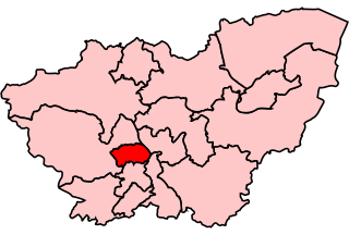
List of electoral wards in South Yorkshire

Last updated

This is a list of electoral divisions and wards in the ceremonial county of South Yorkshire in Yorkshire and the Humber. All changes since the re-organisation of local government following the passing of the Local Government Act 1972 are shown. The number of councillors elected for each electoral division or ward is shown in brackets.

Contents

District councils

Barnsley

Wards from 1 April 1974 (first election 10 May 1973) to 3 May 1979: [1]

Wards from 3 May 1979 to 10 June 2004: [2]

Wards from 10 June 2004 to present: [3] [4]

Barnsley UK ward map 2010 (blank).svg
  1. Central (3)
  2. Cudworth (3)
  3. Darfield (3)
  4. Darton East (3)
  5. Darton West (3)
  6. Dearne North (3)
  7. Dearne South (3)
  8. Dodworth (3)
  9. Hoyland Milton (3)
  10. Kingstone (3)
  11. Monk Bretton (3)
  12. North East (3)
  13. Old Town (3)
  14. Penistone East (3)
  15. Penistone West (3)
  16. Rockingham (3)
  17. Royston (3)
  18. St Helens (3)
  19. Stairfoot (3)
  20. Wombwell (3)
  21. Worsbrough (3)

Doncaster

Wards from 1 April 1974 (first election 10 May 1973) to 1 May 1980: [1]

Wards from 1 May 1980 to 10 June 2004: [5]

Wards from 10 June 2004 to 7 May 2015: [6]

Doncaster UK ward map 2010 (blank).svg
  1. Adwick (3)
  2. Armthorpe (3)
  3. Askern Spa (3)
  4. Balby (3)
  5. Bentley (3)
  6. Bessacarr & Cantley (3)
  7. Central (3)
  8. Conisbrough & Denaby (3)
  9. Edenthorpe, Kirk Sandall & Barnby Dun (3)
  10. Edlington & Warmsworth (3)
  11. Finningley (3)
  12. Great North Road (3)
  13. Hatfield (3)
  14. Mexborough (3)
  15. Rossington (3)
  16. Sprotbrough (3)
  17. Stainforth & Moorends (3)
  18. Thorne (3)
  19. Torne Valley (3)
  20. Town Moor (3)
  21. Wheatley (3)

Wards from 7 May 2015 to present: [7]

Doncaster UK ward map 2015 (blank).svg

Rotherham

Wards from 1 April 1974 (first election 10 May 1973) to 1 May 1980: [1]

Wards from 1 May 1980 to 10 June 2004: [8]

Wards from 10 June 2004 to 6 May 2021: [9]

Rotherham UK ward map 2010 (blank).svg
  1. Anston & Woodsetts (3) †
  2. Boston Castle (3)
  3. Brinsworth & Catcliffe (3)
  4. Dinnington (3) †
  5. Hellaby (3)
  6. Holderness (3)
  7. Hoober (3)
  8. Keppel (3)
  9. Maltby (3)
  10. Rawmarsh (3)
  11. Rotherham East (3)
  12. Rotherham West (3)
  13. Rother Vale (3)
  14. Silverwood (3)
  15. Sitwell (3)
  16. Swinton (3)
  17. Valley (3)
  18. Wales (3)
  19. Wath (3)
  20. Wickersley (3)
  21. Wingfield (3)

† minor boundary changes in 2011 [10]

Wards from 6 May 2021 to present: [11]

  1. Anston and Woodsetts (3)
  2. Aston and Todwick (2)
  3. Aughton and Swallownest (2)
  4. Boston Castle (3)
  5. Bramley and Ravenfield (2)
  6. Brinsworth (2)
  7. Dalton and Thrybergh (2)
  8. Dinnington (3)
  9. Greasbrough (2)
  10. Hellaby and Maltby West (2)
  11. Hoober (3)
  12. Keppel (3)
  13. Kilnhurst and Swinton East (2)
  14. Maltby East (2)
  15. Rawmarsh East (2)
  16. Rawmarsh West (2)
  17. Rother Vale (2)
  18. Rotherham East (3)
  19. Rotherham West (3)
  20. Sitwell (3)
  21. Swinton Rockingham (2)
  22. Thurcroft and Wickersley South (2)
  23. Wales (2)
  24. Wath (2)
  25. Wickersley North (3)

Sheffield

Wards from 1 April 1974 (first election 10 May 1973) to 1 May 1980: [1]

  1. Attercliffe (3)
  2. Beauchief (3)
  3. Birley (3)
  4. Brightside (3)
  5. Broomhill (3)
  6. Burngreave (3)
  7. Castle (3)
  8. Chapel Green (3)
  9. Darnall (3)
  10. Dore (3)
  11. Ecclesall (3)
  12. Firth Park (3)
  13. Gleadless (3)
  14. Hallam (3)
  15. Handsworth (3)
  16. Heeley (3)
  17. Hillsborough (3)
  18. Intake (3)
  19. Manor (3)
  20. Mosborough (3)
  21. Nether Edge (3)
  22. Nether Shire (3)
  23. Netherthorpe (3)
  24. Owlerton (3)
  25. Park (3)
  26. Sharrow (3)
  27. South Wortley (3)
  28. Southey Green (3)
  29. Stocksbridge (3)
  30. Walkley (3)

Wards from 1 May 1980 to 10 June 2004: [12]

  1. Beauchief (3)
  2. Birley (3)
  3. Brightside (3)
  4. Broomhill (3)
  5. Burngreave (3)
  6. Castle (3)
  7. Chapel Green (3)
  8. Darnall (3)
  9. Dore (3)
  10. Ecclesall (3)
  11. Firth Park (3)
  12. Hallam (3)
  13. Handsworth (3)
  14. Heeley (3)
  15. Hillsborough (3)
  16. Intake (3)
  17. Manor (3)
  18. Mosborough (3)
  19. Nether Edge (3)
  20. Nether Shire (3)
  21. Netherthorpe (3)
  22. Norton (3)
  23. Owlerton (3)
  24. Park (3)
  25. Sharrow (3)
  26. South Wortley (3)
  27. Southey Green (3)
  28. Stocksbridge (3)
  29. Walkley (3)

Wards from 10 June 2004 to 5 May 2016: [13]

Sheffield UK ward map 2010 (blank).svg
  1. Arbourthorne (3)
  2. Beauchief and Greenhill (3)
  3. Beighton (3)
  4. Birley (3)
  5. Broomhill and Sharrow Vale (3)
  6. Burngreave (3)
  7. Central (3)
  8. Crookes & Crosspool (3)
  9. Darnall (3)
  10. Dore and Totley (3)
  11. East Ecclesfield (3)
  12. Ecclesall (3)
  13. Firth Park (3)
  14. Fulwood (3)
  15. Gleadless Valley (3)
  16. Graves Park (3)
  17. Hillsborough (3)
  18. Manor Castle (3)
  19. Mosborough (3)
  20. Nether Edge (3)
  21. Richmond (3)
  22. Shiregreen and Brightside (3)
  23. Southey (3)
  24. Stannington (3)
  25. Stocksbridge and Upper Don (3)
  26. Walkley (3)
  27. West Ecclesfield (3)
  28. Woodhouse (3)

Wards from 5 May 2016 to present: [14]

Sheffield UK ward map 2016 (blank).svg

Former county council

South Yorkshire

Electoral Divisions from 1 April 1974 (first election 12 April 1973) to 1 April 1986 (county abolished): [1] [15] [16]

  1. Adwick-le-Street (1)
  2. Barnsley No. 1 (1)
  3. Barnsley No. 2 (1)
  4. Barnsley No. 3 (1)
  5. Barnsley No. 4 (1)
  6. Barnsley No. 5 (1)
  7. Barnsley No. 6 (1)
  8. Bentley-with-Arksey No. 1 (1)
  9. Bentley-with-Arksey No. 2 (1)
  10. Conisbrough (1)
  11. Cudworth (1)
  12. Darfield (1)
  13. Darton (1)
  14. Dearne No. 1 (1)
  15. Dearne No. 2 (1)
  16. Dodworth (1)
  17. Doncaster No. 1 (1)
  18. Doncaster No. 2 (1)
  19. Doncaster No. 3 (1)
  20. Doncaster No. 4 (Wheatley) (1)
  21. Doncaster No. 5 (Intake) (1)
  22. Doncaster No. 6 (Bessacarr) (1)
  23. Doncaster Rural No. 1 (1)
  24. Doncaster Rural No. 2 (1)
  25. Doncaster Rural No. 3 (1)
  26. Doncaster Rural No. 4 (1)
  27. Doncaster Rural No. 5 (1)
  28. Doncaster Rural No. 6 (1)
  29. Hemsworth (1)
  30. Hoyland (1)
  31. Kiveton Park No. 1 (1)
  32. Kiveton Park No. 2 (1)
  33. Maltby (1)
  34. Mexborough (1)
  35. Penistone (1)
  36. Penistone Rural (1)
  37. Rawmarsh No. 1 (1)
  38. Rawmarsh No. 2 (1)
  39. Rotherham No. 1 (1)
  40. Rotherham No. 2 (1)
  41. Rotherham No. 3 (1)
  42. Rotherham No. 4 (1)
  43. Rotherham No. 5 (1)
  44. Rotherham No. 6 (1)
  45. Rotherham Rural No. 1 (1)
  46. Rotherham Rural No. 2 (1)
  47. Rotherham Rural No. 3 (1)
  48. Rotherham Rural No. 4 (1)
  49. Rotherham Rural No. 5 (1)
  50. Royston (1)
  51. Sheffield No. 1 (3)
  52. Sheffield No. 2 (3)
  53. Sheffield No. 3 (3)
  54. Sheffield No. 4 (3)
  55. Sheffield No. 5 (3)
  56. Sheffield No. 6 (3)
  57. Sheffield No. 7 (3)
  58. Sheffield No. 8 (3)
  59. Sheffield No. 9 (3)
  60. Sheffield No. 10 (3)
  61. Sheffield No. 11 (3)
  62. Sheffield No. 12 (3)
  63. Sheffield No. 13 (3)
  64. Stocksbridge (1)
  65. Swinton (1)
  66. Thorne No. 1 (1)
  67. Thorne No. 2 (1)
  68. Thorne No. 3 (1)
  69. Wath upon Dearne (1)
  70. Wombwell (1)
  71. Worsbrough (1)
  72. Wortley No. 1 (1)
  73. Wortley No. 2 (1)
  74. Wortley No. 3 (1)

Electoral wards by constituency

Barnsley Central

Central, Darton East, Darton West, Kingstone, Monk Bretton, Old Town, Royston, St Helens.

Barnsley East

Cudworth, Darfield, Hoyland Milton, North East, Rockingham, Stairfoot, Wombwell, Worsbrough.

Don Valley

Conisbrough and Denaby, Edlington and Warmsworth, Finningley, Hatfield, Rossington, Thorne, Torne Valley.

Doncaster Central

Armthorpe, Balby, Bessacarr and Cantley, Central, Edenthorpe, Hexthorpe & Balby North, Kirk Sandall and Barnby Dun, Town Moor, Wheatley.

Doncaster North

Adwick, Askern, Bentley, Great North Road, Mexborough, Sprotbrough, Stainforth and Moorends.

Penistone and Stocksbridge

East Ecclesfield, Dodworth, Penistone East, Penistone West, Stocksbridge and Upper Don, West Ecclesfield.

Rother Valley

Anston and Woodsetts, Dinnington, Hellaby, Holderness, Maltby, Rother Vale, Sitwell, Wales.

Rotherham

Boston Castle, Brinsworth and Catcliffe, Keppel, Rotherham East, Rotherham West, Valley, Wingfield.

Sheffield, Brightside and Hillsborough

Burngreave, Firth Park, Hillsborough, Shiregreen and Brightside, Southey.

Sheffield Central

Broomhill, Central, Manor Castle, Nether Edge, Walkley.

Sheffield, Hallam

Crookes, Dore and Totley, Ecclesall, Fulwood, Stannington.

Sheffield, Heeley

Arbourthorne, Beauchief and Greenhill, Gleadless Valley, Graves Park, Richmond.

Sheffield South East

Beighton, Birley, Darnall, Mosborough, Woodhouse.

Wentworth and Dearne

Dearne North, Dearne South, Hoober, Rawmarsh, Silverwood, Swinton, Wath, Wickersley.

See also

Related Research Articles

<span class="mw-page-title-main">Sheffield Hallam (UK Parliament constituency)</span> Parliamentary constituency in the United Kingdom, 1885 onwards

Sheffield Hallam is a constituency represented in the House of Commons of the UK Parliament since 2019 by Olivia Blake of the Labour Party.

<span class="mw-page-title-main">Ecclesall</span> Electoral ward in the City of Sheffield, South Yorkshire, England

Ecclesall Ward—which includes the neighbourhoods of Banner Cross, Bents Green, Carterknowle, Ecclesall, Greystones, Millhouses, and Ringinglow—is one of the 28 electoral wards in the City of Sheffield, England. It is located in the southwestern part of the city and covers an area of 3.6 square miles. The population of this ward in 2007 was 19,211 people in 7,626 households, reducing to 6,657 at the 2011 Census. Ecclesall ward is one of the four wards that make up the South West Community Assembly and one of five wards that make up the Sheffield Hallam Parliamentary constituency. The Member of Parliament is Olivia Blake, a Labour MP. Ecclesall is one of the least socially deprived wards in the entire country, with a 2002 deprivation score of 4.7—making it the 8,105th most deprived ward out of 8,414 wards in the country. The demographic consists largely of white, middle-class families.

In England, a township is a local division or district of a large parish containing a village or small town usually having its own church. A township may or may not be coterminous with a chapelry, manor, or any other minor area of local administration.

<span class="mw-page-title-main">Broomhill and Sharrow Vale</span> Electoral ward in the City of Sheffield, South Yorkshire, England

Broomhill and Sharrow Vale — which includes the districts of Broomhill, Broomhall, Crookesmoor, Endcliffe, Sharrow Vale and Tapton Hill — is one of the 28 electoral wards in City of Sheffield, England. The ward was created following the 2015 local government boundary review out of parts of the old Broomhill, Central and Nether Edge wards. It is located in the western part of the city. The population of the Broomhill ward in 2011 was 16,966 people in 5,708 households, covering an area of 2.7 km2. Broomhill & Sharrow Vale is one of the wards that make up the Sheffield Central Parliamentary Constituency.

<span class="mw-page-title-main">Metropolitan Borough of Rotherham</span> Metropolitan borough in South Yorkshire, England

The Metropolitan Borough of Rotherham is a metropolitan borough of South Yorkshire, England. It is named after its largest town, Rotherham, but also spans the outlying towns of Maltby, Swinton, Wath-upon-Dearne, Dinnington and also the villages of Rawmarsh and Laughton. A large valley also spans the entire borough. Locally known as the Rother Valley.

<span class="mw-page-title-main">Sheffield Brightside (UK Parliament constituency)</span> Parliamentary constituency in the United Kingdom, 1885–2010

Sheffield, Brightside was a parliamentary constituency in the City of Sheffield. Created for the 1885 general election, and replaced at the 2010 general election by the new constituency of Sheffield Brightside and Hillsborough, it elected one Member of Parliament (MP) to the House of Commons of the Parliament of the United Kingdom, using the first-past-the-post voting system.

<span class="mw-page-title-main">Sheffield Attercliffe (UK Parliament constituency)</span> Parliamentary constituency in the United Kingdom, 1885–2010

Sheffield Attercliffe was a parliamentary constituency in the City of Sheffield. It was created at the 1885 general election and abolished at the 2010 general election, when it was replaced by a new Sheffield South East constituency.

<span class="mw-page-title-main">Sheffield Central (UK Parliament constituency)</span> UK Parliament constituency in England

Sheffield Central is a constituency represented in the House of Commons of the UK Parliament since 2010 by Paul Blomfield, a member of the Labour Party.

<span class="mw-page-title-main">Wentworth (UK Parliament constituency)</span> Parliamentary constituency in the United Kingdom, 1983–2010

Wentworth was a parliamentary constituency in South Yorkshire. Originally created in 1918 and was abolished in 1950, the name was revived when a new constituency was created from 1983 to 2010. Throughout its history, Wentworth was a safe seat for the Labour Party.

<span class="mw-page-title-main">Areas of Sheffield</span>

The areas of Sheffield, a city and metropolitan borough in the north of England, vary widely in size and history. Some of the areas developed from villages or hamlets, that were absorbed into Sheffield as the city grew, and thus their centres are well defined, but the boundaries of many areas are ambiguous. The areas of Sheffield do not play a significant administrative role, but the city is divided into 28 electoral wards for local elections and 6 parliamentary constituencies for national elections.

<span class="mw-page-title-main">East Ecclesfield</span> Electoral ward in the City of Sheffield, South Yorkshire, England

East Ecclesfield ward—which includes the districts of Chapeltown and Ecclesfield—is one of the 28 electoral wards in City of Sheffield, England. It is located in the northern part of the city and covers an area of 3.8 square miles (9.8 km2) in the eastern part of Ecclesfield Parish. The population of this ward in 2011 was 18,295 people in 7,863. East Ecclesfield is one of the six wards that make up the Sheffield Hillsborough Parliamentary constituency. The Boundary Commission for England, in their final report, recommended that East Ecclesfield should become part of a reformed Penistone and Stocksbridge constituency. The East Ecclesfield ward is composed of eight polling districts. These include Blackburn, Chapeltown, Ecclesfield, Ecclesfield Common, High Greave, Horbury, Warren and Wheata.

<span class="mw-page-title-main">Penistone and Stocksbridge (UK Parliament constituency)</span> Parliamentary constituency in the United Kingdom

Penistone and Stocksbridge is a constituency in the House of Commons of the UK Parliament represented since 2019 by Miriam Cates, a Conservative. As with all constituencies, adults qualifying to vote in the seat elect one Member of Parliament (MP) by the first past the post system of election at least every five years.

<span class="mw-page-title-main">Diocese of Sheffield</span> Diocese of the Church of England

The Diocese of Sheffield is an administrative division of the Church of England, part of the Province of York.

<span class="mw-page-title-main">2004 Sheffield City Council election</span>

Elections to Sheffield City Council were held on 10 June 2004. The whole council was up for election with boundary changes having taken place since the last election in 2003, reducing the number of seats by 3. This election was the first all-postal vote election held, dramatically improving overall turnout by 14.4% on the previous election to 43.9%. The Labour Party kept its overall majority and continued to run the council, albeit on a much slimmer majority. Previous to the boundary changes, sitting Hillsborough councillor Peter MacLoughlin defected from the Liberal Democrats to an Independent, choosing not to contest this election.

The Sheriff of Hallamshire was a shrievalty title which was in existence from 1962 until 1974 in Yorkshire, United Kingdom.

The Sheffield, Rotherham, Barnsley, Wakefield, Huddersfield and Goole Railway was an early British railway company. The company obtained an act in 1846 for 26 miles of railway, with a main section from Wakefield to Doncaster via Barnsley.

<span class="mw-page-title-main">2016 Sheffield City Council election</span>

Sheffield City Council elections took place on Thursday 5 May 2016, alongside nationwide local elections. All 84 seats were up for election, 3 per ward, after several electoral boundaries were changed. Labour, the Liberal Democrats and the Green Party contested all 84 seats. The Conservatives fielded 55 candidates, UKIP 43, TUSC 23 and Yorkshire First 1. There was also 1 independent candidate. Voters in the Sheffield Brightside and Hillsborough Parliamentary constituency also elected Gill Furniss MP, in a by-election triggered by the death of her husband Harry Harpham MP.

There are a number of listed buildings in South Yorkshire. The term "listed building", in the United Kingdom, refers to a building or structure designated as being of special architectural, historical, or cultural significance. Details of all the listed buildings are contained in the National Heritage List for England. They are categorised in three grades: Grade I consists of buildings of outstanding architectural or historical interest, Grade II* includes significant buildings of more than local interest and Grade II consists of buildings of special architectural or historical interest. Buildings in England are listed by the Secretary of State for Culture, Media and Sport on recommendations provided by English Heritage, which also determines the grading.

References

  1. 1 2 3 4 5 The County of South Yorkshire (Electoral Divisions and Wards) Order 1973
  2. The Borough of Barnsley (Electoral Arrangements) Order 1978
  3. legislation.gov.uk - The Borough of Barnsley (Electoral Changes) Order 2003. Retrieved on 3 November 2015.
  4. legislation.gov.uk - The Borough of Barnsley (Electoral Changes) (Amendment) Order 2004. Retrieved on 3 November 2015.
  5. The Borough of Doncaster (Electoral Arrangements) Order 1979
  6. legislation.gov.uk - The Borough of Doncaster (Electoral Changes) Order 2004. Retrieved on 3 November 2015.
  7. legislation.gov.uk - The Doncaster (Electoral Changes) Order 2015. Retrieved on 3 November 2015.
  8. The Borough of Rotherham (Electoral Arrangements) Order 1979
  9. legislation.gov.uk - The Borough of Rotherham (Electoral Changes) Order 2004. Retrieved on 3 November 2015.
  10. legislation.gov.uk - The Rotherham (Electoral Changes) Order 2011. Retrieved on 3 November 2015.
  11. "Borough Election Result 6 May 2021". Rotherham Metropolitan Borough Council . Retrieved 15 July 2021.
  12. legislation.gov.uk - The City of Sheffield (Electoral Arrangements) Order 1979. Retrieved on 19 November 2015.
  13. legislation.gov.uk - The City of Sheffield (Electoral Changes) Order 2004. Retrieved on 3 November 2015.
  14. legislation.gov.uk - The Sheffield (Electoral Changes) Order 2015. Retrieved on 20 April 2016.
  15. Rallings, Colin; Thrasher, Michael. Local Elections Handbook 1973. The Elections Centre. Retrieved 3 May 2016.
  16. Rallings, Colin; Thrasher, Michael. Local Elections Handbook 1977. The Elections Centre. Retrieved 3 May 2016.