County council
Gloucestershire
Electoral Divisions from 1 April 1974 (first election 12 April 1973) to 2 May 1985: [1] [2]
- Berkeley (1)
- Bisley (1)
- Cam (1)
- Charlton Kings (1)
- Cheltenham (All Saints) (1)
- Cheltenham (College) (1)
- Cheltenham (Hatherley) (1)
- Cheltenham (Hesters Way) (1)
- Cheltenham (Lansdown) (1)
- Cheltenham (Park) (1)
- Cheltenham (Pittville) (1)
- Cheltenham (St Marks) (1)
- Cheltenham (St Pauls) (1)
- Cheltenham (St Peters) (1)
- Cheltenham Rural No. 1 (Winchcombe) (1)
- Cheltenham Rural No. 2 (1)
- Cheltenham Rural No. 3 (1)
- Cheltenham Rural No. 4 (1)
- Cheltenham Rural No. 5 (1)
- Cirencester (North) (1)
- Cirencester (South) (1)
- Cirencester Rural No. 1 (1)
- Cirencester Rural No. 2 (1)
- Dursley (1)
- East Dean No. 1 (Mitcheldean) (1)
- East Dean No. 2 (Cinderford) (1)
- East Dean No. 3 (1)
- East Dean No. 4 (1)
- Gloucester (Barnwood) (1)
- Gloucester (Barton) (1)
- Gloucester (Eastgate) (1)
- Gloucester (Hucclecote) (1)
- Gloucester (Kingsholm) (1)
- Gloucester (Linden) (1)
- Gloucester (Longlevens) (1)
- Gloucester (Matson) (1)
- Gloucester (Podsmead) (1)
- Gloucester (Tuffley) (1)
- Gloucester (Westgate) (1)
- Gloucester Rural No. 1 (Brockworth) (1)
- Gloucester Rural No. 2 (Churchdown) (1)
- Gloucester Rural No. 3 (1)
- Gloucester Rural No. 4 (1)
- Lydney (1)
- Minchinhampton (1)
- Nailsworth (1)
- Newent (1)
- North Cotswold No. 1 (Campden) (1)
- North Cotswold No. 2 (1)
- North Cotswold No. 3 (1)
- Northleach (1)
- Painswick (1)
- Stonehouse (1)
- Stroud East (1)
- Stroud West (1)
- Tetbury (1)
- Tewkesbury (1)
- Tidenham (1)
- West Dean No. 1 (1)
- West Dean No. 2 (1)
- Wotton-under-Edge (1)
Electoral Divisions from 2 May 1985 to 5 May 2005: [2] [3]
- All Saints (1)
- Ashchurch & Twyning (1)
- Barnwood (1)
- Barton (1)
- Berkeley Vale (1)
- Bishops Cleeve & Swindon (1); electoral division abolished in 1991 [4]
- Bisley (1)
- Bourton & Stow (1)
- Brockworth & Hucclecote (1)
- Brooksdean (1)
- Cam (1)
- Charlton Kings (1)
- Churchdown (1)
- Cinderford (1)
- Cirencester North (1)
- Cirencester South (1)
- Coleford (1)
- College (1)
- Cotswold Edge (1); electoral division abolished in 1991 [4]
- Dursley (1)
- East Cotswold (1)
- East Dean (1)
- Eastgate (1)
- Hatherley (1) †
- Hesters Way (1)
- Hucclecote (1)
- Kingsholme (1) †
- Lansdown (1)
- Linden (1)
- Longlevens (1) †
- Lydney (1)
- Matson (1) †
- Mid-Tewkesbury (1) †
- Minchinhampton (1)
- Moreton-in-the-Marsh (1)
- Nailsworth (1)
- Newent (1)
- North Cotswold (1)
- Northleach (1)
- Painswick (1)
- Park (1)
- Pittville (1)
- Podsmead (1)
- Prestbury (1)
- Quedgeley (1) †
- Severn (1) †
- Severn Dean (1)
- Severn Vale (1) †
- South Cotswold (1) †
- St Marks (1)
- St Pauls (1)
- St Peters (1) †
- Stonehouse (1)
- Stroud East (1)
- Stroud West (1)
- Tetbury (1)
- Tewkesbury (1)
- Tidenham (1)
- Tuffley (1)
- West Dean (1)
- Westgate (1) †
- Winchcombe (1) †
- Wotton-under-Edge (1)
- Bishop’s Cleeve (1); new electoral division added in 1991 [4]
- Leckhampton with Up Hatherley (1); new electoral division added in 1991 [4]
† minor boundary changes in 1991 [4]
Electoral Divisions from 5 May 2005 to 2 May 2013: [5]
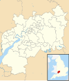
- Abbey (1)
- All Saints (2)
- Ashchurch, Cleeve & Oxenton Hill (1)
- Barnwood (1)
- Barton & Tredworth (1)
- Berkeley Vale (1)
- Bourton (1) †
- Brockworth (1)
- Brooksdean (1)
- Cam & Dursley (2)
- Chalford (1)
- Charlton Kings (1)
- Churchdown Brookfield (1)
- Churchdown St John's (1)
- Cinderford (1)
- Cirencester (2)
- Cleeve (1)
- Coleford (1)
- East Cotswold (1) †
- Hesters Way & Up Hatherley (2)
- Hucclecote (1)
- Lansdown, Park & Warden Hill (2)
- Longlevens (1)
- Lydney (1)
- Mid Dean (1)
- Moreland (1)
- Moreton-Stow (1)
- Nailsworth & Minchinhampton (1) †
- Newent (1)
- North Cotswold (1)
- North Stroud (1)
- Northleach (1)
- Oakley, Pittville & Prestbury (2)
- Pillowell & Littledean (1)
- Podsmead (1)
- Quedgeley (2)
- Robinswood (1)
- Rodborough (1) †
- Severn Vale (1)
- South Cotswold (1)
- Springbank (1)
- St Mark's, St Paul’s & St Peter's (2)
- Stonehouse (1)
- Stroud East (1)
- Stroud West (1)
- Tetbury (1)
- Tewkesbury (2)
- Tidenham (1)
- Upton St Leonards, Bisley & Painswick (1)
- West Dean (1)
- Westgate (2)
- Winchcombe (1)
- Wotton-under-Edge (1)
† minor boundary changes in 2009 [6] [7]
Electoral Divisions from 2 May 2013 to present: [8]

- Abbey (1)
- All Saints & Oakley (1)
- Barnwood & Hucclecote (1)
- Barton & Tredworth (1)
- Battledown & Charlton Kings (1)
- Benhall & Up Hatherley (1)
- Bishop’s Cleeve (1)
- Bisley & Painswick (1)
- Blakeney & Bream (1)
- Bourton-on-the-Water & Northleach (1)
- Brockworth (1)
- Cam Valley (1)
- Campden-Vale (1)
- Charlton Park & College (1)
- Churchdown (1)
- Cinderford (1)
- Cirencester Beeches (1)
- Cirencester Park (1)
- Coleford (1)
- Coney Hill & Matson (1)
- Drybrook & Lydbrook (1)
- Dursley (1)
- Fairford & Lechlade on Thames (1)
- Grange & Kingsway (1)
- Hardwicke & Severn (1)
- Hempsted & Westgate (1)
- Hesters Way & Springbank (1)
- Highnam (1)
- Kingsholm & Wotton (1)
- Lansdown & Park (1)
- Leckhampton & Warden Hill (1)
- Longlevens (1)
- Lydney (1)
- Minchinhampton (1)
- Mitcheldean (1)
- Nailsworth (1)
- Newent (1)
- Pittville & Prestbury (1)
- Quedgeley (1)
- Rodborough (1)
- Sedbury (1)
- South Cerney (1)
- St Mark’s & St Peter’s (1)
- St Paul’s & Swindon (1)
- Stonehouse (1)
- Stow-on-the-Wold (1)
- Stroud Central (1)
- Tetbury (1)
- Tewkesbury (1)
- Tewkesbury East (1)
- Tuffley (1)
- Winchcombe & Woodmancote (1)
- Wotton-under-Edge (1)


