Listed buildings in Scrooby

Last updated

Scrooby is a civil parish in the Bassetlaw District of Nottinghamshire, England. The parish contains 17 listed buildings that are recorded in the National Heritage List for England. Of these, one is listed at Grade II*, the middle of the three grades, and the others are at Grade II, the lowest grade. The parish contains the village of Scooby and the surrounding countryside, and the listed buildings include houses, cottages and associated structures, churches, farmhouses and farm buildings, a former watermill, a pinfold, a war memorial, and a telephone kiosk.

Contents

Key

GradeCriteria [1]
II*Particularly important buildings of more than special interest
IIBuildings of national importance and special interest

Buildings

Name and locationPhotographDateNotesGrade
St Wilfrid's Church
53°24′35″N1°01′14″W / 53.40961°N 1.02042°W / 53.40961; -1.02042 (St Wilfrid's Church)
St.Wilfrid's, Scrooby - geograph.org.uk - 173934.jpg
15th centuryThe church has been altered and extended through the centuries, and it was restored in 1864. It is built in stone with slate roofs, and consists of a nave, a south aisle and chapel, a south porch, a chancel and a west steeple. The steeple has a tower with two stages, a string course, an arched west window with three lights and a hood mould, two-light arched bell openings, and an embattled parapet with corner crocketed pinnacles. The angles of the parapet are chamfered and have small diagonal buttresses, rising to an octagonal spire with a weather vane. The body of the church also has embattled parapets. [2] [3] II*
Manor House Farmhouses
53°24′40″N1°01′03″W / 53.41119°N 1.01745°W / 53.41119; -1.01745 (Manor House Farmhouses)
Former farmhouse at Manor Farm - geograph.org.uk - 4259585.jpg
16th centuryOriginally a moated palace occupied by Archbishops of York, it has been largely demolished, later extended and used as a farmhouse, and then divided into two cottages. It is in red brick and stone, on a plinth with a chamfered course above, and has dentilled eaves, and a half-hipped pantile roof. There are two storeys and seven bays, the right bay projecting slightly, and a rear outshut. On the front are a doorway, and a canted bay window. Most of the windows are casements, some in segmental aches, and there is a 16th-century mullioned window with two arched lights and a quoined surround. [4] [5] II
The Old Vicarage
53°24′35″N1°01′16″W / 53.40972°N 1.02107°W
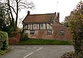
 / 53.40972; -1.02107 (The Old Vicarage)
The Old Vicarage, Scrooby - geograph.org.uk - 4259635.jpg
Early 17th century (probable)The house has a ground floor in red brick with a blue brick band at the base, the upper floor is timber framed with plaster infill, and there is a pantile roof with stone coped gables and kneelers. There are two storeys and two bays, one long and the other shorter, a lean-to on the right, and a single-storey two-bay rear extension. Most of the windows are horizontally-sliding sashes. [2] [6] II
Barn, Holmefield Farm
53°24′39″N1°01′17″W / 53.41086°N 1.02150°W / 53.41086; -1.02150 (Barn, Holmefield Farm)
Homefield Farmhouse and barn range - geograph.org.uk - 4259630.jpg
17th centuryThe barn has a timber framed core, it was encased in red brick in the 19th century, and has a pantile roof with a brick coped left gable. It contains a two-storey doorway, vents and a fixed light. Attached to the barn is a single-storey lean-to containing a doorway with a segmental head, and projecting from it is a single-storey wing. [7] II
Monk's Mill and wall
53°24′43″N1°01′19″W / 53.41190°N 1.02187°W / 53.41190; -1.02187 (Monk's Mill and wall)
Monk's Mill, Scrooby - geograph.org.uk - 4259618.jpg
17th centuryA watermill, later a house and outbuildings, in red brick and stone, with dentilled eaves and pantile roofs, consisting of a row of buildings with different heights. On the right is a block with two storeys and an attic and three bays, to its right is a wing with two storeys and four bays, to its left is a two-storey three-bay wing, to the left is a two-storey two-bay wing, and finally a single-storey single-bay wing. The windows are a mix of casements, horizontally-sliding sashes and fixed lights. In front of the mill is a brick wall with stone coping containing three mill races with two brick arches and cutwaters. [4] [8] II
Scrooby Top House
53°23′36″N1°01′05″W / 53.39325°N 1.01808°W / 53.39325; -1.01808 (Scrooby Top House)
Scrooby Top House - geograph.org.uk - 2445037.jpg
Early 18th centuryOriginally a staging post on the Great North Road, later a house and a restaurant, it is in rendered red brick on a stone plinth, with sill and floor bands, and a hipped pantile roof. There are three storeys, five bays, and flanking two-storey two-bay wings, the left with a pantile roof, and the right with a slate roof. In the centre is a doorway with attached Doric columns, an entablature, and a traceried semicircular fanlight with a keystone. The windows are sashes, in the ground floor with splayed lintels and keystones, and those in the middle floor and the central window in the top floor with keystones. [4] [9] II
Holmefield Farmhouse
53°24′39″N1°01′18″W / 53.41070°N 1.02162°W / 53.41070; -1.02162 (Holmefield Farmhouse)
Homefield Farmhouse and barn range - geograph.org.uk - 4259630.jpg
Mid 18th centuryThe farmhouse is in red brick, with dentilled eaves, and a pantile roof with stone coped gables and kneelers. There are two storeys and a main range of three bays, and to the right is a lower two-storey single-bay wing with a lean-to. The central doorway has a fanlight, and the windows are casements. [10] II
Mill House
53°24′39″N1°01′13″W / 53.41087°N 1.02037°W / 53.41087; -1.02037 (Mill House)
Mill House, Scrooby - geograph.org.uk - 4259610.jpg
Mid 18th centuryA house in red brick, the gables rendered, with a floor band, dogtooth eaves and a pantile roof. There are two storeys, three bays, and rear extensions. In the centre is a doorway, above which is a blocked window, and flanking the doorway are canted bay windows, above which are sash windows. All the openings are under segmental arches. [11] II
Scrooby Top Cottages and attached buildings
53°23′36″N1°01′05″W / 53.39346°N 1.01809°W / 53.39346; -1.01809 (Scrooby Top Cottages and attached buildings)
Scrooby Top cottages - geograph.org.uk - 4259557.jpg
Mid 18th centuryA row of cottages and former stables in red brick with dentilled eaves and pantile roofs. In the centre is a two-storey three-bay cottage with a pyramidal roof. This contains a floor band, a central a blocked arch with impost blocks flanked by pilasters, above which is a round panel. The windows are horizontally-sliding sashes under segmental arches. To the left is a lower range with two storeys and five bays, containing a blocked arch with impost blocks and sash windows, those in the ground floor with segmental heads. To the right is a single-storey stable block containing doorways of different sizes, a blocked arch, and a casement window under a segmental arch. [12] II
Bishopfield House
53°23′27″N1°01′48″W / 53.39097°N 1.02987°W / 53.39097; -1.02987 (Bishopfield House)
Bishopfield House, Scrooby - geograph.org.uk - 4260481.jpg
Late 18th centuryA stuccoed house on a plinth, with moulded floor and sill bands, corner pilasters, an eaves band, and a hipped slate roof with overhanding eaves on brackets. There are two storeys and a front of three bays, the middle bay projecting slightly, and recessed to the left is a wing with a single storey and an attic, and three bays in painted brick. In the centre of the main block is a porch with paired Doric columns and a doorway with a moulded surround and a traceried fanlight. Most of the windows are sashes. The garden front has four bays and a four-bay verandah with a decorative fascia on seven iron columns. [4] [13] II
Low Farmhouse
53°24′38″N1°01′11″W / 53.41048°N 1.01979°W
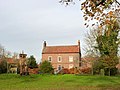
 / 53.41048; -1.01979 (Low Farmhouse)
Low Farmhouse, Scrooby - geograph.org.uk - 4259579.jpg
Late 18th centuryThe farmhouse is in red brick with a floor band, dogtooth and dentilled eaves and a pantile roof. There are two storeys and attics, and three bays. In the centre is a porch, and the windows are sashes with splayed lintels. At the rear is a lean-to, and a wing with two storeys and five bays containing a porch, and a doorway, a sash window and a horizontally-sliding sash window, the last three under segmental arches. Inside the rear wing is an inglenook fireplace. [14] II
Pigeoncote, Manor Farm
53°24′40″N1°01′05″W / 53.41117°N 1.01792°W
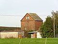
 / 53.41117; -1.01792 (Pigeoncote, Manor Farm)
Pigeoncote at Manor Farm - geograph.org.uk - 4259582.jpg
Late 18th centuryThe pigeoncote is in red brick with some render and stone, and has dentilled eaves and a corrugated roof. At the gable end is a dentilled cornice forming a pediment in which is an arched opening with a wooden panel containing three pigeonholes. External steps lead to an upper floor doorway under a segmental arch, and in the east front is an opening under a segmental arch containing a fanlight. [4] [15] II
Barn range and pigeoncote,
Low Farm
53°24′39″N1°01′11″W / 53.41074°N 1.01970°W
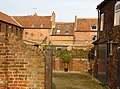
 / 53.41074; -1.01970 (Barn Range and Pigeoncote, Low Farm)
Farm buildings at Low Farm - geograph.org.uk - 4259606.jpg
Early 19th centuryThe farm buildings are in red brick with dentilled eaves and pantile roofs. They consist of a two-storey barn, beyond which are two-storey and lower outbuildings, and a pigeoncote projecting at right angles with two storeys and an attic. The openings in the barns and outbuildings include doorways, some under segmental arches, and vents. The pigeoncote contains various openings, and in the attic is a gabled dormer with pigeonholes. Inside, there are nesting boxes. [16] II
Scrooby Methodist Church
53°24′36″N1°01′16″W / 53.41008°N 1.02106°W / 53.41008; -1.02106 (Scrooby Methodist Church)
Scrooby Methodist Chapel - geograph.org.uk - 4259632.jpg
1829–30The church is in painted and rendered brick with a hipped slate roof. There is a single storey and three bays. In the centre is a flat-roofed porch containing a doorway with a segmental head and a fanlight, and in the outer bays are arched sash windows. To the left is a lower extension in painted brick, and to the right is a rendered and coped wall, both with arched doorways. [2] [17] II
War memorial
53°24′35″N1°01′12″W / 53.40961°N 1.02008°W / 53.40961; -1.02008 (War memorial)
War Memorial, Scrooby.jpg
1920The war memorial in the churchyard of St Wilfrid's Church is in polished grey granite. It consists of a broken column on a tapering plinth, on a two-stage square base, on a single-step base. On the memorial is an inscription and the names of those lost in the First World War. [18] II
Telephone kiosk
53°24′37″N1°01′17″W / 53.41023°N 1.02137°W
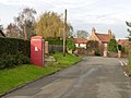
 / 53.41023; -1.02137 (Telephone kiosk)
Chapel Lane, Scrooby - geograph.org.uk - 4259637.jpg
1935The K6 type telephone kiosk in Chapel Lane was designed by Giles Gilbert Scott. Constructed in cast iron with a square plan and a dome, it has three unperforated crowns in the top panels. [19] II
Churchyard wall and pinfold
53°24′35″N1°01′12″W / 53.40966°N 1.02004°W / 53.40966; -1.02004 (Churchyard wall and pinfold)
Scrooby Pinfold - geograph.org.uk - 4259569.jpg
UndatedThe east and north sides of the churchyard of St Wilfrid's Church are enclosed by a stone coped wall with some brick infill. On the east side is a double wrought iron gate flanked by stone piers with shaped coping, and on the north side is a wooden gate with small wooden piers. Projecting from the northwest is the village pinfold with a stone wall containing a wooden gate and piers. [2] [20] II

Related Research Articles

Darlton is a civil parish in the Bassetlaw District of Nottinghamshire, England. The parish contains seven listed buildings that are recorded in the National Heritage List for England. Of these, one is listed at Grade II*, the middle of the three grades, and the others are at Grade II, the lowest grade. The parish contains the village of Darlton and the surrounding countryside. The listed buildings consist of a church, chest tombs in the churchyard, and the lychgate and wall at its entrance, a house, a farmhouse, and farm buildings.

Epperstone is a civil parish in the Newark and Sherwood district of Nottinghamshire, England. The parish contains 22 listed buildings that are recorded in the National Heritage List for England. Of these, one is listed at Grade I, the highest of the three grades, and the others are at Grade II, the lowest grade. The parish contains the village of Epperstone and the surrounding countryside. Most of the listed buildings are houses, cottages and associated structures, farmhouses and farm buildings, including three pigeoncotes. The other listed buildings include a church, a former chapel, a former mill, a pinfold, a former library and a telephone kiosk.


Fiskerton cum Morton is a civil parish in the Newark and Sherwood district of Nottinghamshire, England. The parish contains eight listed buildings that are recorded in the National Heritage List for England. Of these, one is at Grade II*, the middle of the three grades, and the others are at Grade II, the lowest grade. The parish contains the villages of Fiskerton and Morton, and the surrounding area. The listed buildings consist of houses, a cottage, a church, a pigeoncote, a farmhouse and a public house.

Flintham is a civil parish in the Rushcliffe district of Nottinghamshire, England. The parish contains 38 listed buildings that are recorded in the National Heritage List for England. Of these, two are listed at Grade I, the highest of the three grades, and the others are at Grade II, the lowest grade. The parish contains the village of Flintham and the surrounding area. The most important buildings in the parish are a church and the country house, Flintham Hall, which are both listed at Grade I. A number of structures associated with the hall are listed, and the other listed buildings consist of houses, cottages and associated structures, farmhouses and farm buildings, a pinfold, a former school and a telephone kiosk.

Grassthorpe is a civil parish in the Newark and Sherwood district of Nottinghamshire, England. The parish contains five listed buildings that are recorded in the National Heritage List for England. All the listed buildings are designated at Grade II, the lowest of the three grades, which is applied to "buildings of national importance and special interest". The parish contains the village of Grassthorpe and the surrounding countryside. The listed buildings consist of a house, a cottage, a pigeoncote, a footbridge and a pinfold.

Halam is a civil parish in the Newark and Sherwood district of Nottinghamshire, England. The parish contains 20 listed buildings that are recorded in the National Heritage List for England. Of these, one is listed at Grade I, the highest of the three grades, and the others are at Grade II, the lowest grade. The parish contains the village of Halam and the surrounding countryside. Most of the listed buildings are houses, cottages and associated structures, farmhouses and farm buildings, including three pigeoncotes. The other listed buildings consist of a church, a mill with an attached house and a footbridge, and a public house.

Hawksworth is a civil parish in the Rushcliffe district of Nottinghamshire, England. The parish contains six listed buildings that are recorded in the National Heritage List for England. Of these, one is listed at Grade II*, the middle of the three grades, and the others are at Grade II, the lowest grade. The parish contains the village of Hawksworth and the surrounding area. All the listed buildings are in the village, and consist of a church, its former rectory, houses, farmhouses and associated structures, and farm buildings.

Hayton is a civil parish in the Bassetlaw District of Nottinghamshire, England. The parish contains eleven listed buildings that are recorded in the National Heritage List for England. Of these, one is listed at Grade I, the highest of the three grades, and the others are at Grade II, the lowest grade. The parish contains the village of Hayton and the surrounding countryside. Most of the listed buildings are houses, farmhouses and farm buildings, and the others consist of a church, a war memorial in the churchyard, and two bridges over the Chesterfield Canal.

Linby is a civil parish in the Gedling district of Nottinghamshire, England. The parish contains 27 listed buildings that are recorded in the National Heritage List for England. Of these, two are listed at Grade II*, the middle of the three grades, and the others are at Grade II, the lowest grade. The parish contains the village of Linby and the surrounding countryside. Most of the listed buildings are houses, cottages and associated structures, farmhouses and farm buildings. The others include a church, a headstone in the churchyard, two village crosses, a water mill, two boundary markers and a telephone kiosk.


Marnham is a civil parish in the Bassetlaw District of Nottinghamshire, England. The parish contains seven listed buildings that are recorded in the National Heritage List for England. Of these, one is listed at Grade I, the highest of the three grades, and the others are at Grade II, the lowest grade. The parish contains the settlements of High Marnham, Low Marnham and Skegby, and the surrounding countryside. The listed buildings consist of a church, two houses, a pigeoncote, a village hall, a farmhouse and farm buildings.

Scarrington is a civil parish in the Rushcliffe district of Nottinghamshire, England. The parish contains seven listed buildings that are recorded in the National Heritage List for England. Of these, one is listed at Grade I, the highest of the three grades, and the others are at Grade II, the lowest grade. The parish contains the village of Scarrington and the surrounding area. The listed buildings consist of a church, houses and associated structures, a smithy and a pinfold.

Screveton is a civil parish in the Rushcliffe district of Nottinghamshire, England. The parish contains nine listed buildings that are recorded in the National Heritage List for England. Of these, one is listed at Grade I, the highest of the three grades, and the others are at Grade II, the lowest grade. The parish contains the village of Screveton and the surrounding countryside. All the listed buildings are in the village, and consist of a church, items in and around the churchyard, a house, farmhouses and associated structures, and a pinfold.

South Scarle is a civil parish in the Newark and Sherwood district of Nottinghamshire, England. The parish contains ten listed buildings that are recorded in the National Heritage List for England. Of these, one is listed at Grade I, the highest of the three grades, and the others are at Grade II, the lowest grade. The parish contains the village of South Scarle and the surrounding area. All the listed buildings are in the village, and consist of a church, houses cottages and farmhouses, a pigeoncote and a barn.

Staunton is a civil parish in the Newark and Sherwood district of Nottinghamshire, England. The parish contains eleven listed buildings that are recorded in the National Heritage List for England. Of these, two are listed at Grade II*, the middle of the three grades, and the others are at Grade II, the lowest grade. The parish contains the village of Staunton and the surrounding countryside. The listed buildings consist of a church, a country house and associated structures, a pigeoncote, a farmhouse, a cottage, a public house and a telephone kiosk.

Syerston is a civil parish in the Newark and Sherwood district of Nottinghamshire, England. The parish contains seven listed buildings that are recorded in the National Heritage List for England. All the listed buildings are designated at Grade II, the lowest of the three grades, which is applied to "buildings of national importance and special interest". The parish contains the village of Syerston and the surrounding area. The listed buildings consist of a country house and associated structures, a smaller house, a farmhouse and a former barn, and a church.

Thoroton is a civil parish in the Rushcliffe district of Nottinghamshire, England. The parish contains five listed buildings that are recorded in the National Heritage List for England. Of these, one is listed at Grade I, the highest of the three grades, and the others are at Grade II, the lowest grade. Grades are designated by interest in preservation. The parish contains the village of Thoroton and the surrounding area. All the listed buildings are in the village, and consist of a church, a pigeoncote, a manor house, a house and a range of associated buildings.

Upton is a civil parish in the Newark and Sherwood district of Nottinghamshire, England. The parish contains 24 listed buildings that are recorded in the National Heritage List for England. Of these, one is listed at Grade I, the highest of the three grades, two are at Grade II*, the middle grade, and the others are at Grade II, the lowest grade. The parish contains the village of Upton and the surrounding countryside. To the east of the parish is a former workhouse, which is listed together with its infirmary. The other listed buildings are in the village, and consist of a church, headstones in the churchyard, a former country house and its gateway, smaller houses, cottages, farmhouses, and associated structures, a public house and a telephone kiosk.

West Drayton is a civil parish in the Bassetlaw District of Nottinghamshire, England. The parish contains 13 listed buildings that are recorded in the National Heritage List for England. Of these, one is listed at Grade II*, the middle of the three grades, and the others are at Grade II, the lowest grade. The parish contains the villages of West Drayton, Markham Moor and Rockley, and the surrounding countryside. Most of the listed buildings are houses, a cottage, farmhouses, and associated structures, and the others are a church, a road bridge, a water mill, a public house, a milestone, and the canopy of a former petrol station.

Weston is a civil parish in the Newark and Sherwood district of Nottinghamshire, England. The parish contains six listed buildings that are recorded in the National Heritage List for England. Of these, one is listed at Grade I, the highest of the three grades, and the others are at Grade II, the lowest grade. The parish contains the village of Weston and the surrounding countryside, and the listed buildings consist of a church, a sundial in the churchyard, houses and farmhouses and associated structures.

Woodborough is a civil parish in the Gedling district of Nottinghamshire, England. The parish contains 16 listed buildings that are recorded in the National Heritage List for England. Of these, two are listed at Grade II*, the middle of the three grades, and the others are at Grade II, the lowest grade. The parish contains the village of Woodborough and the surrounding area. All the listed buildings are in the village, and consist of a church, houses, cottages and associated structures, including two water pumps, and a telephone kiosk.

References

Citations

Sources

  • Historic England, "Church of St Wilfrid, Scrooby (1239733)", National Heritage List for England , retrieved 6 September 2023
  • Historic England, "Manor House Farmhouses, Scrooby (1239774)", National Heritage List for England, retrieved 6 September 2023
  • Historic England, "The Old Vicarage, Scrooby (1239432)", National Heritage List for England, retrieved 6 September 2023
  • Historic England, "Barn at Holmefield Farm, Scrooby (1273708)", National Heritage List for England, retrieved 5 September 2023
  • Historic England, "Monk's Mill and Wall Containing Mill Race, Scrooby (1267745)", National Heritage List for England, retrieved 6 September 2023
  • Historic England, "Scrooby Top Farmhouse Restaurant, Scrooby (1239681)", National Heritage List for England, retrieved 6 September 2023
  • Historic England, "Holmefield Farmhouse, Scrooby (1239644)", National Heritage List for England, retrieved 5 September 2023
  • Historic England, "Mill House, Scrooby (1239433)", National Heritage List for England, retrieved 6 September 2023
  • Historic England, "Scrooby Top Cottages and Attached Buildings, Scrooby (1273709)", National Heritage List for England, retrieved 6 September 2023
  • Historic England, "Bishopfield House, Scrooby (1239871)", National Heritage List for England, retrieved 6 September 2023
  • Historic England, "Low Farmhouse, Scrooby (1239771)", National Heritage List for England, retrieved 5 September 2023
  • Historic England, "Pigeoncote at Manor Farm, Scrooby (1239773)", National Heritage List for England, retrieved 6 September 2023
  • Historic England, "Barn Range and Pigeoncote at Low Farm, Scrooby (1239772)", National Heritage List for England, retrieved 5 September 2023
  • Historic England, "Scrooby Methodist Church, Scrooby (1239431)", National Heritage List for England, retrieved 6 September 2023
  • Historic England, "Scrooby War Memorial, Scrooby (1421773)", National Heritage List for England, retrieved 6 September 2023
  • Historic England, "K6 Telephone Kiosk, Scrooby (1222659)", National Heritage List for England, retrieved 6 September 2023
  • Historic England, "Churchyard Wall Village Pinfold, Scrooby (1239660)", National Heritage List for England, retrieved 6 September 2023
  • Hartwell, Clare; Pevsner, Nikolaus; Williamson, Elizabeth (2020) [1979]. Nottinghamshire. The Buildings of England. New Haven and London: Yale University Press. ISBN   978-0-300-24783-1.
  • Historic England, Listed Buildings , retrieved 5 September 2023