Shropshire is a county in the West Midlands region of England. In 2009 the historic county was divided into two unitary authorities, Shropshire and Telford and Wrekin. These two unitary authorities constitute the ceremonial county of Shropshire, which forms the basis for this list. The county's economy is largely agricultural. Until the creation of the new town of Telford in the 1960s, the largest town was its county town, Shrewsbury. Shropshire is the largest entirely inland county in England. Its churches are mainly constructed from local stone. This is mainly sandstone, although there are limestone deposits in the northeast of the county. The Triassic sandstone from quarries at Grinshill is considered to be one of the finest types of stone in the county for building.
Abdon is a former civil parish, now in the parish of Abdon and Heath, in Shropshire, England, and includes the settlements of Abdon, Tugford, Beambridge, and Holdgate. It contains 22 listed buildings that are recorded in the National Heritage List for England. Of these, one is listed at Grade I, the highest of the three grades, three are at Grade II*, the middle grade, and the others are at Grade II, the lowest grade. The parish is entirely rural. Most of the listed buildings are churches and associated structures in the churchyards. The other listed buildings consist of houses, a former mill and stables, a bridge, and a telephone kiosk.
Adderley is a civil parish in Shropshire, England. It contains 26 listed buildings that are recorded in the National Heritage List for England. Of these, one is listed at Grade I, the highest of the three grades, and the others are at Grade II, the lowest grade. Apart from the village of Adderley, the parish is rural. Two country houses were demolished in the 1950s, Adderley Hall, and Shavington Hall, but a number of structures associated with them have survived and are listed, including stable blocks, farmhouses and farm buildings, and bridges. The Shropshire Union Canal passes through the parish, and a number of bridges and two mileposts associated with it are listed. The other listed buildings include a church and associated structures.
Alberbury with Cardeston is a civil parish in Shropshire, England. It contains 58 listed buildings that are recorded in the National Heritage List for England. Of these, one is listed at Grade I, the highest of the three grades, seven are at Grade II*, the middle grade, and the others are at Grade II, the lowest grade. The parish contains the villages and settlements of Alberbury, Cardeston, Wollaston, Halfway House, and Rowton, and is otherwise rural. In the parish the listed buildings include two ruined castles, two country houses and associated structures including lodges, and three churches and items in the churchyards. Most of the other listed buildings are houses, cottages, farmhouses and farm buildings, and the rest include the remains of a windmill, two milestones, a public house, and a war memorial. Three of the listed buildings are also Scheduled Monuments.
Berrington is a civil parish in Shropshire, England. It contains 43 listed buildings that are recorded in the National Heritage List for England. Of these, one is listed at Grade I, the highest of the three grades, two are at Grade II*, the middle grade, and the others are at Grade II, the lowest grade. The parish contains the villages of Berrington, Betton Strange, Cross Houses, and is otherwise rural. Most of the listed buildings are houses and associated structures, farmhouses and farm buildings, many of them dating from the 17th century or before, and basically timber framed. There are two listed churches, the older church All Saints Church, Berrington also having listed structures in the churchyard. In addition, the listed buildings include two bridges, a former hospital, a milestone and a milepost, a number of pumps, some with associated troughs, and a war memorial.
Cheswardine is a civil parish in Shropshire, England. It contains 21 listed buildings that are recorded in the National Heritage List for England. Of these, one is listed at Grade II*, the middle of the three grades, and the others are at Grade II, the lowest grade. The parish includes the village of Cheswardine, and smaller settlements including Ellerton, and is otherwise rural. The Shropshire Union Canal passes through the parish, and associated with his are eleven listed buildings, namely eight bridges and three mileposts. The other listed buildings are a church and associated structures, a watermill, a country house, and smaller houses and farmhouses.
Condover is a civil parish in Shropshire, England. It contains 96 listed buildings that are recorded in the National Heritage List for England. Of these, two are listed at Grade I, the highest of the three grades, three are at Grade II*, the middle grade, and the others are at Grade II, the lowest grade. The parish contains the villages of Condover, Dorrington, Great Ryton, and Stapleton, and smaller settlements, but is mainly rural. Most of the listed buildings are houses, cottages, farmhouses and farm buildings, the earliest of which are timber framed, some with cruck construction. The most important building in the parish is the country house Condover Hall; this and associated structures are listed. The other listed buildings include churches and items in the churchyards, bridges, public houses, and a war memorial.
Eaton-under-Heywood is a civil parish in Shropshire, England. It contains 17 listed buildings that are recorded in the National Heritage List for England. Of these, one is listed at Grade I, the highest of the three grades, three are at Grade II*, the middle grade, and the others are at Grade II, the lowest grade. The parish contains the villages of Eaton and Ticklerton, and smaller settlements including Birtley and Soudley, and is otherwise rural. Most of the listed buildings are houses and associated structures, farmhouses and farm buildings. The other listed buildings are a church, a sundial and a monument in the churchyard, and a war memorial.
Great Ness is a civil parish in Shropshire, England. It contains 26 listed buildings that are recorded in the National Heritage List for England. Of these, one is listed at Grade I, the highest of the three grades, one is at Grade II*, the middle grade, and the others are at Grade II, the lowest grade. The parish contains the village of Great Ness and smaller settlements, including Alderton, Kinton, and Nesscliffe, and is otherwise rural. Most of the listed buildings are houses, farmhouses and farm buildings, and the other listed buildings include a church and items in the churchyard, a hotel, milestones, and a war memorial.
Hadnall is a civil parish in the district of Telford and Wrekin, Shropshire, England. It contains twelve listed buildings that are recorded in the National Heritage List for England. Of these, one is at Grade II*, the middle of the three grades, and the others are at Grade II, the lowest grade. The parish contains the village of Hadnall and the surrounding countryside. The listed buildings consist of houses and farmhouses with associated structures, a church, a windmill converted into a house, the lodge to a former mansion, a public house, and a charnel house.
Hodnet is a civil parish in Shropshire, England. It contains 59 listed buildings that are recorded in the National Heritage List for England. Of these, two are listed at Grade I, the highest of the three grades, five are at Grade II*, the middle grade, and the others are at Grade II, the lowest grade. The parish contains the villages of Hodnet, Peplow, and Wollerton, and smaller settlements, and is otherwise mainly rural. The oldest building in the parish is the 12th-century St Luke's Church, which is listed, together with its lychgate. In the parish are two country houses that are listed, with associated structures. Most of the other listed buildings are houses, cottages, farmhouses and farm buildings, many of which are timber framed and date from the 15th to the 18th centuries. Also listed are an animal pound, three mileposts, another church, and a telephone kiosk.
Moreton Corbet and Lee Brockhurst is a civil parish in Shropshire, England. It contains 45 listed buildings that are recorded in the National Heritage List for England. Of these, three are listed at Grade I, the highest of the three grades, two are at Grade II*, the middle grade, and the others are at Grade II, the lowest grade. The parish contains the villages and smaller settlements of Acton Reynald, Moreton Corbet, Lee Brockhurst, and Preston Brockhurst, and the surrounding countryside. Most of the listed buildings are houses and cottages, farmhouses and farm buildings and associated structures, the earliest of which are timber framed. The other listed buildings include churches, memorials, a ruined castle and mansion, country houses and associated structures, a former watermill, a bridge, and two mileposts.
Moreton Say is a civil parish in Shropshire, England. It contains 21 listed buildings that are recorded in the National Heritage List for England. Of these, two are at Grade II*, the middle of the three grades, and the others are at Grade II, the lowest grade. The parish includes villages and smaller settlements, including Bletchley, Longford, and Moreton Say, and is otherwise rural. Most of the listed buildings are houses and cottages, farmhouses and farm buildings, the earliest of which are timber framed, one with cruck construction. The other listed buildings include a small country house and associated structures, a church and a tomb in the churchyard, a milepost, and a pump.
Pimhill is a civil parish in Shropshire, England. It contains 67 listed buildings that are recorded in the National Heritage List for England. Of these, twelve are at Grade II*, the middle of the three grades, and the others are at Grade II, the lowest grade. The parish is to the northwest of Shrewsbury, it contains the villages of Albrighton, Atcham, Fitz, Leaton, Merrington and Preston Gubbals and smaller settlements, and is otherwise rural. In the parish are a former manor house and seven country houses that are listed, together with structures associated with them. Otherwise, most of the listed buildings are smaller houses, cottages, farmhouses and farm buildings, the older of which are timber framed, or have timber-framed cores. The other listed buildings include churches and items in the churchyards, a private chapel, a group of almshouses, an eyecatcher, a war memorial, and five mileposts,
Sheriffhales is a civil parish in Shropshire, England. It contains 32 listed buildings that are recorded in the National Heritage List for England. Of these, two are listed at Grade II*, the middle of the three grades, and the others are at Grade II, the lowest grade. The parish contains the villages of Sheriffhales and Chadwell and smaller settlements, and is otherwise mainly rural. In the parish is Lilleshall Hall, a country house, later a National Sports Centre. This is listed, together with associated structures. Most of the other listed buildings are houses, cottages, farmhouses and farm buildings, the earliest of which are timber framed or have timber-framed cores. The remainder of the listed buildings include a church, items in the churchyard, a wayside cross, a milestone and a milepost, a watermill, and a war memorial.
Smethcott is a civil parish in Shropshire, England. It contains 21 listed buildings that are recorded in the National Heritage List for England. Of these, one is listed at Grade II*, the middle of the three grades, and the others are at Grade II, the lowest grade. The parish contains the villages of Smethcott, Betchcott, and Picklescott, and is otherwise rural. The listed buildings consist of houses, farmhouses and farm buildings and associated structures, a public house, and a church.
Stanton Lacy is a civil parish in Shropshire, England. It contains 22 listed buildings that are recorded in the National Heritage List for England. Of these, one is listed at Grade I, the highest of the three grades, one is at Grade II*, the middle grade, and the others are at Grade II, the lowest grade. The parish contains the village of Stanton Lacy and smaller settlements, and is otherwise rural. Most of the listed buildings are houses, farmhouses and farm buildings, many of which are timber framed, or have a timber-framed core. The other listed buildings consist of a church, a sundial in the churchyard, a country house and associated buildings, a milestone, a war memorial, and a telephone kiosk.
Stoke upon Tern is a civil parish in Shropshire, England. It contains 21 listed buildings that are recorded in the National Heritage List for England. Of these, one is listed at Grade II*, the middle of the three grades, and the others are at Grade II, the lowest grade. The parish includes the villages of Stoke on Tern, Ollerton, and Wistanswick and smaller settlements, and is otherwise rural. Most of the listed buildings are farmhouses and farm buildings, many of which are timber framed. The other listed buildings consist of a church with groups of coffin slabs and a former font in the churchyard, another church, a row of cottages, two milestones, a bridge, and an animal pound.
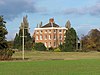
Sutton upon Tern is a civil parish in Shropshire, England. It contains 24 listed buildings that are recorded in the National Heritage List for England. Of these, four are listed at Grade II*, the middle of the three grades, and the others are at Grade II, the lowest grade. The parish contains the village of Sutton upon Tern and is otherwise largely rural. The Shropshire Union Canal passes through the parish, and the listed buildings associated with it are two bridges and a milepost. In the parish are the country houses Buntingsdale Hall and Pell Wall, and another large house, Colehurst Manor, which are listed together with associated structures. The other listed buildings are farmhouses, farm buildings, a road bridge, a milestone, and a coach house and stables.
Westbury is a civil parish in Shropshire, England. It contains 55 listed buildings that are recorded in the National Heritage List for England. Of these, five are listed at Grade II*, the middle of the three grades, and the others are at Grade II, the lowest grade. The parish contains the villages of Westbury, Stoney Stretton and Yockleton, and smaller settlements, and is otherwise rural. Most of the listed buildings are houses and associated structures, cottages, farmhouses and farm buildings, the earliest of which are timber framed or have timber-framed cores. The other listed buildings include two churches, items in a churchyard, a country house and associated structures, and a watermill.