
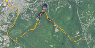
The Passaic River is a river, approximately 80 miles (130 km) long, in northern New Jersey. The river in its upper course flows in a highly circuitous route, meandering through the swamp lowlands between the ridge hills of rural and suburban northern New Jersey, called the Great Swamp, draining much of the northern portion of the state through its tributaries.

Green Village is an unincorporated community and census-designated place (CDP) within Harding and Chatham townships in Morris County, New Jersey, United States. As of the 2020 census, it had a population of 1,103. It is located just north of the Great Swamp National Wildlife Refuge and is named after Ashbel Green, former president of Princeton University.

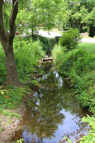
Foudry Brook is a small stream in southern England. It rises from a number of springs near the Hampshire village of Baughurst, and flows to the east and then the north, to join the River Kennet to the south of Reading. The upper section is called Silchester Brook, and beyond that, Bishop's Wood Stream. The underlying geology is chalk, covered by a layer of clay, and so it has the characteristics of a clay stream, experiencing rapid increases in level after heavy rain due to run-off from the surrounding land. It passes a number of listed buildings and scheduled monuments, including the site of the Roman town of Calleva Atrebatum or Silchester.

Effluent is wastewater from sewers or industrial outfalls that flows directly into surface waters, either untreated or after being treated at a facility. The term has slightly different meanings in certain contexts, and may contain various pollutants depending on the source.

Alewife Brook Reservation is a Massachusetts state park and urban wild located in Cambridge, Arlington, and Somerville. The park is managed by the state Department of Conservation and Recreation and was established in 1900. It is named for Alewife Brook, which was also historically known as Menotomy River, a tributary of the Mystic River.

The Pawtuxet River, also known as the Pawtuxet River Main Stem and the Lower Pawtuxet, is a river in the U.S. state of Rhode Island. It flows 12.3 miles (19.8 km) and empties into the upper Narragansett Bay of the Atlantic Ocean. Together with its two main tributary branches, the North Branch Pawtuxet River and the South Branch Pawtuxet River, it drains a watershed of 231.6 square miles (600 km2), all of which is in the state of R.I.
The Great Swamp Watershed Association is a member-based, non-profit, 501(c)(3) conservation organization dedicated to preserving and protecting water and natural areas. Their programs serve all who live, work, or play in the Great Swamp watershed in Morris County, New Jersey. For over 40 years the association has been acting on behalf of local communities to ensure that water is safe and pure and open space is protected.

Water pollution in New Zealand is an increasing concern for those who use and care for waterways and for New Zealand regulatory bodies. An increase in population is linked to an increase in water pollution, due to a range of causes such as rural land use, industrial use and urban development. Fresh water quality is under pressure from agriculture, hydropower, urban development, pest invasions and climate change. While pollution from point sources has been reduced, diffuse pollution such as nutrients, pathogens and sediments development and from stormwater in towns is not under control. There are more than 800 water quality monitoring sites around New Zealand that are regularly sampled.

Water pollution is an environmental issue on the West Coast of New Zealand. Water resources and water pollution come under the jurisdiction of the Resource Management Act and is controlled by the regional councils - for the West Coast it is the West Coast Regional Council.
The Loantaka Brook Reservation is a nature reserve and public park in the American state of New Jersey in Morris County. It consists of five miles of nature trails for jogging, hiking, and biking. Seaton Hackney Stables, owned and operated by the Morris County Park Commission, offers horseback riding at an adjacent property with trail riding along a long and narrow corridor near the Loantaka Brook. It has four distinct areas including the South Street recreation facilities, the Seaton Hackney Stables, the Loantaka Brook area at Kitchell Road, and the Loantaka Way Trail.
Lewis Run is a tributary of Roaring Brook in Luzerne County, Pennsylvania, in the United States. It is approximately 3.6 miles (5.8 km) long and flows through Ross Township and Hunlock Township. A relatively small amount on non-municipal sewage is discharged into the stream. However, it is not considered to be impaired and wild trout naturally reproduce within it.

Spring Brook is a tributary of the Lackawanna River in Lackawanna County and Luzerne County, in Pennsylvania, in the United States. It is approximately 17 miles (27 km) long and flows through Covington Township, Spring Brook Township, and Moosic in Lackawanna County and Pittston Township in Luzerne County. The watershed of the stream has an area of 57.2 square miles (148 km2). It is designated as a High-Quality Coldwater Fishery and a Migratory Fishery above Interstate 476 and as a Coldwater Fishery and a Migratory Fishery below it. A section is also designated as Class A Wild Trout Waters. The stream's tributaries include Panther Creek, Plank Bridge Creek, Rattlesnake Creek, Green Run, Monument Creek, and Covey Swamp Creek. It has a relatively high level of water quality and is very slightly acidic, with a pH of 6.4 to 6.9.
Stafford Meadow Brook is a tributary of the Lackawanna River in Lackawanna County, Pennsylvania, in the United States. It is approximately 11.2 miles (18.0 km) long and flows through Roaring Brook Township, Scranton, and Moosic. The watershed of the stream has an area of 14.1 square miles (37 km2). Part of it is designated as a High-Quality Coldwater Fishery and a Migratory Fishery. The other part is a Warmwater Fishery and a Migratory Fishery. The stream has one named tributary, which is known as Mountain Lake Run. Stafford Meadow Brook has a very high level of water quality for much of its length and part of it meets the criteria for an Exceptional Value designation. The stream begins on the Pocono Plateau and flows through the Moosic Mountains in a mountainous watershed. Its channel has been substantially altered in its lower reaches.

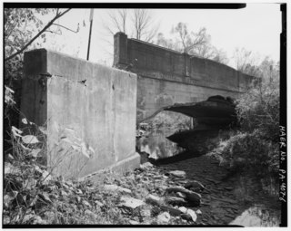
Roaring Brook is a tributary of the Lackawanna River in Lackawanna County, Pennsylvania, in the United States. It is approximately 21 miles (34 km) long and flows through Covington Township, Madison Township, Moscow, Roaring Brook Township, Elmhurst Township, Dunmore, and Scranton. The watershed of the stream has an area of 56.3 square miles (146 km2). Its named tributaries include Little Roaring Brook, Rock Bottom Creek, White Oak Run, Van Brunt Creek, Bear Brook, and East Branch Roaring Brook. It has a high level of water quality for much of its length. However, it is affected by abandoned mining land, stormwater, and other impacts in its lower reaches. Reservoirs in the watershed include the Hollister Reservoir, the Elmhurst Reservoir, and others. The stream also flows through the Nay Aug Gorge and passes over the Nay Aug Falls, which are on the National Register of Geologic Landmarks. It flows through a concrete channel in its lower reaches. The topography of the watershed contains rolling hills in its upper reaches and the mountainous land of the Moosic Mountains in its lower reaches.

Leggetts Creek is a tributary of the Lackawanna River in Lackawanna County, Pennsylvania, in the United States. It is approximately 9.0 miles (14.5 km) long and flows through Scott Township, South Abington Township, and Scranton. The watershed of the creek has an area of 18.5 square miles (48 km2). The creek has three named tributaries: Leach Creek, Clover Hill Creek, and Summit Lake Creek. Leggetts Creek is considered to be impaired due to urban development problems, but is not affected by acid mine drainage. The creek is fairly alkaline and is a perennial stream. Its headwaters are in wetlands outside of the Lackawanna Valley and it flows through a water gap known as Leggetts Gap or The Notch. Major lakes in the watershed include the Griffin Reservoir, Summit Lake, and Maple Lake. The creek is a source of flooding in South Abington Township.
Leach Creek is a tributary of Leggetts Creek in Lackawanna County, Pennsylvania, in the United States. It is approximately 1.9 miles (3.1 km) long and flows through Scranton. The watershed of the creek has an area of 2.55 square miles (6.6 km2). The creek loses substantial amounts of water to underground mine pools. The creek is in the Coal Region and has been channelized and/or culvertized in some reaches. It flows alongside Pennsylvania Route 307 for a substantial part of its length. The creek has a riparian buffer in its upper and middle reaches, but various invasive plants grow along its banks in its lower reaches.
Swale Brook is a tributary of Tunkhannock Creek in Wyoming County, Pennsylvania, in the United States. It is approximately 2.9 miles (4.7 km) long and flows through Tunkhannock Township and Tunkhannock. The watershed of the stream has an area of 4.01 square miles (10.4 km2). The stream is not designated as an impaired waterbody. The surficial geology near it consists of alluvium, alluvial terrace, Wisconsinan Outwash, Wisconsinan Till, Wisconsinan Ice-Contact Stratified Drift, fill, and a wetland.
Ackerly Creek is a tributary of South Branch Tunkhannock Creek in Lackawanna County, Pennsylvania, in the United States. It is approximately 8.7 miles (14.0 km) long and flows through South Abington Township, Waverly Township, Glenburn Township, Dalton, and La Plume Township. The creek has several unnamed tributaries and drains an area of nearly 18 square miles (47 km2). Ackerly Creek is not designated as an impaired waterbody, but it is impacted by some water quality problems. In one reach, the creek flows through Rabbit Hollow, which is set aside as a preserve. The creek experiences some erosion due to its banks being managed and straightened where it flows alongside US Route 6 and US Route 11.
Black Run is a tributary of the West Branch Susquehanna River in Lycoming County and Union County, in Pennsylvania, in the United States. It is approximately 3.6 miles (5.8 km) long and flows through Brady Township in Lycoming County and Gregg Township in Union County. The watershed of the stream has an area of 5.87 square miles (15.2 km2). The stream is not designated as an impaired waterbody. It is a relatively small stream with its mouth located near Montgomery. The stream's watershed is designated as a Warmwater Fishery and a Migratory Fishery.
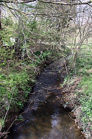
Barkham Brook is a small river in the English county of Berkshire. It has sources to the north and west of Finchampstead in the Wokingham Borough, flows past the village of Barkham, and joins the River Loddon to the west of Winnersh.
