Loma, Colorado

Last updated

Loma, Colorado
Loma, Colorado.JPG
Mesa County Colorado Incorporated and Unincorporated areas Loma Highlighted 0845750.svg
Usa edcp location map.svg
Red pog.svg
Loma
Location in the United States
Coordinates: 39°12′27″N108°48′18″W / 39.20750°N 108.80500°W / 39.20750; -108.80500 (Loma CDP, Colorado) [1]
Country Flag of the United States.svg  United States
State Flag of Colorado.svg  Colorado
County Mesa County
Government
[1]
  Type unincorporated town
Area
[2]
  Total10.889 sq mi (28.20 km2)
  Land10.889 sq mi (28.20 km2)
  Water0.0 sq mi (0 km2)
Elevation
[1]
4,524 ft (1,379 m)
Population
 (2020) [3]
  Total1,314
  Density120/sq mi (47/km2)
Time zone UTC-7 (MST)
  Summer (DST) UTC-6 (MDT)
ZIP Code [4]
81524
Area code 970
GNIS feature 2629991 [1]

Loma is an unincorporated town, post office, and census-designated place (CDP) located in and governed by Mesa County, Colorado, United States. It is part of the Grand Junction, CO Metropolitan Statistical Area. The Loma post office has the ZIP Code 81524. [4] At the 2020 census, the population of the Loma CDP was 1,314. [5]

Contents

History

The name "Loma" is derived from a Spanish word meaning "small hill". [6]

The area was first inhabited by the Ute people, who had left by 1881. [7]

In 1882, the Denver and Rio Grande Western Railroad completed a narrow-gauge railroad through Loma. A standard-gauge track was installed in 1890. [8]

Homesteaders began arriving in Loma in the late 1880s. [7] [8] Agriculture became a dominant feature in Loma's early economy, enabled by the completion of the Kiefer Extension irrigation canal in 1899. [7] The railway provided easy shipment of crops and livestock to larger cities like Denver and Salt Lake City. [8]

The first school was established in the 1890s, and the two-story Loma School was constructed in 1910 from yellow brick, fired on the grounds. The brick school remained in use until 1982, when Loma Elementary School opened. [8] [9]

In 1901, the Colorado Sugar Company opened 1,000 acres (400 ha) of land near Loma to settlers. Sugar beets were a primary crop, and beet production dominated Loma's agriculture until the 1970s, when the Delta Sugar Beet factory closed. [7] [8] Potatoes were also grown by Loma farmers. [8]

The Loma post office opened in 1905, and has continued in operation since. [10]

In 1910, the church now known as Loma Community Church was built. It has often been referred to as "The Church That Stayed". Virginia Donoho produced a 15,000 word history of the church by that same name in the early 1980s. In 1965 the building added indoor plumbing, a fellowship hall, a kitchen, and two bathrooms. In the late 1970s a small addition was built.

Verner Zevola Reed, known as "The Colorado Millionaire"", opened the Golden Hills ranch on 1,200 acres (490 ha) of land he had purchased 2 mi (3.2 km) north of Loma in 1907. Reed intended on growing apples, and installed an underground irrigation system to water his orchards. In 1911, the Loma Canning and Preserving Company opened a canning factory in Loma to process the anticipated harvests. The endeavor was not a success, and the factory closed a few years later without ever reaching its capacity. Reed sold the Golden Hills Ranch in 1923. [8] [11]

A second irrigation canal called the Highline Canal was built through Loma in 1917, and led to significant economic growth and several bumper crops during the 1920s. [7] [8] [9]

By 1923, Loma had a school, blacksmith, garage, railroad station, school, two-story hotel, shipping yard, post office, pool hall, two churches, two grocery stores, and many two-story homes. [7]

During the Depression, the federal government relocated 32 families from the Dust Bowl to Loma. [8] [9]

A "reading room" was established in Loma in 1936 as part of an effort to provide rural citizens in Mesa County with free public library service. [12] In 1938, the Loma Community Hall was erected, and was used for community meetings and social events. The hall was added to the National Register of Historic Places in 1995. [13]

A uranium mine and mill were built near Loma in the 1940s. Small settlements such as Loma with uranium mines were called "yellowcake towns" because the uranium oxide they produced resembled cake mix. [14]

In the 1950s, a pipeline was constructed along an abandoned Uintah Railway track to carry a mixture of crushed gilsonite ore and water from Bonanza, Utah, to Loma. The American Gilsonite Company owned the slurry line and built a plant in Loma, where the gilsonite was refined into gasoline, "gilsapave" paving tar, and briquettes used for aluminum refining. The plant was later purchased by Gary Refining. [7] [8] [11]

In July 2015, the Colorado Department of Transportation installed Loma's first signal light at the intersection of Highway 139 and Route 6.[ citation needed ]

Country Jam is a country music and camping festival in nearby Mack that has taken place since 1992.

Geography

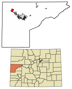
Loma is located in northwestern Mesa County, 18.5 mi (29.8 km) northwest of Grand Junction, the Mesa county seat. U.S. Route 6 passes through the center of town, leading northwest 3.5 miles (5.6 km) to Mack and southeast 5 miles (8 km) to Fruita. Interstate 70 forms the southern edge of the Loma CDP, with access from Exit 15 (Colorado State Highway 139). Highway 139 leads north from Loma over Douglas Pass 71 miles (114 km) to Rangely. The Colorado River flows south of Loma.

Loma has been described as having:

A sense of openness that is created by farmsteads, viable agriculture, farm based businesses, small subdivisions, mixed housing types and lot sizes, single-lane farm roads, and two core villages [Loma and Mack] that are the focal points of the surrounding landscape. The underpinnings of rural character is supported by this self chosen lifestyle of small town values, family, community, independence, responsibility, conservation, entrepreneurship, and a strong work ethic. [9]

The Loma CDP has an area of 10.9 square miles (28 km2), all land. [2]

Demographics

The United States Census Bureau initially defined the Loma CDP for the United States Census 2010.

Loma CDP, Colorado
YearPop.±%
2010 1,293    
2020 1,314+1.6%
Source: United States Census Bureau

Economy

The current agricultural base of the Loma area consists mainly of small-scale cattle operations, row crop cultivation, and lifestyle agriculture. [9]

Parks and recreation

The Loma Community Park covers about 0.5 acres (0.20 ha) and includes a small playground. [9]

There is significant publicly owned land in and around Loma, managed primarily by the Bureau of Land Management. [9] The Loma Boat Launch State Wildlife Area, located south of Loma, is a popular access point to the Colorado River for recreation activities. [9] [15] The trailhead of the Kokopelli Trail, a 142 mi (229 km) recreation trail, is located southwest of Loma. [16] The trail passes through the 123,430-acre (49,950 ha) McInnis Canyons National Conservation Area south of Loma. [17]

Education

Education is provided by the Mesa County Valley School District 51.

Loma Elementary School is located in Loma. Its mascot is the lion, and school colors are green and white. [18] After elementary school, Loma students attend Fruita Middle School and Fruita Monument High School in Fruita.

Media

KCDC radio station is located in Loma. [19]

Infrastructure

Law Enforcement is provided by the Mesa County Sheriff and the Colorado State Patrol. Fire protection is provided by the Lower Valley Volunteer Fire District, which has a station in Loma. [9]

Notable people

See also

Related Research Articles

<span class="mw-page-title-main">Mesa County, Colorado</span> County in Colorado, United States

Mesa County is a county located in the U.S. state of Colorado. As of the 2020 census, the population was 155,703. The county seat and most populous municipality is Grand Junction. The county was named for the many large mesas in the area, including the Grand Mesa, which is the largest flat-topped mountain in the world.

<span class="mw-page-title-main">Highlands Ranch, Colorado</span> Census Designated Place in Colorado, United States

Highlands Ranch is an unincorporated community and a census-designated place (CDP) located in and governed by Douglas County, Colorado, United States. The CDP is a part of the Denver–Aurora–Lakewood, CO Metropolitan Statistical Area. The population of the Highlands Ranch CDP was 105,631 at the United States Census 2020, making it the most populous unincorporated community in the State of Colorado. The Highlands Ranch Metropolitan District provides services to the community, which lies in ZIP Codes 80126, 80129, 80130, and 80163.

<span class="mw-page-title-main">Windsor, Colorado</span> Town in Colorado, United States

Windsor is a home rule municipality in Larimer and Weld counties in the U.S. state of Colorado. According to the 2020 census, the population of the town was 32,716. Windsor is located in the Northern Colorado region. Someone who lives in the municipality is known as a "Winsord."

<span class="mw-page-title-main">Fruita, Colorado</span> City in Colorado, United States

Fruita is a home rule municipality located in western Mesa County, Colorado, United States. The city population was 13,395 at the 2020 United States Census. Fruita is a part of the Grand Junction, CO Metropolitan Statistical Area and lies within the Grand Valley. The geography is identified by the bordering Colorado River on the southern edge of the town, the Uncompahgre Plateau known for its pinyon-juniper landscape, and the Book Cliffs range on the northern edge of the Grand Valley. Originally home to the Ute people, white farmers settled the town after founder William Pabor in 1884. Ten years later, Fruita was incorporated.

<span class="mw-page-title-main">Grand Junction, Colorado</span> City in and county seat of Mesa County, Colorado, United States

Grand Junction is a home rule municipality that is the seat of government and largest city of Mesa County, Colorado, United States. Grand Junction's population was 65,560 at the 2020 United States Census, making it the most populous city in western Colorado and the 17th most populous Colorado municipality overall.

<span class="mw-page-title-main">Redlands, Colorado</span> Census-designated place in Colorado, United States

Redlands is an unincorporated community and census-designated place (CDP) located in and governed by Mesa County, Colorado, United States. It is part of the Grand Junction, CO Metropolitan Statistical Area. The population of the Redlands CDP was 9,061 at the 2020 census. The Grand Junction post office serves the area.

<span class="mw-page-title-main">Loghill Village, Colorado</span> Census-designated place in Ouray County, Colorado, United States

Loghill Village is a Census-designated place (CDP) in and governed by Ouray County, Colorado, United States. The CDP is a part of the Montrose, CO Micropolitan Statistical Area. The population of the Loghill Village CDP was 617 at the United States Census 2020. The Ridgway post office (Zip Code 81432) serves Loghill Village postal addresses.

<span class="mw-page-title-main">Beltsville, Maryland</span> CDP in Maryland

Beltsville is a census-designated place (CDP) in northern Prince George's County, Maryland, United States. The community was named for Truman Belt, a local landowner. The 2020 census counted 20,133 residents. Beltsville includes the unincorporated community of Vansville.

<span class="mw-page-title-main">Belfry, Montana</span> Census-designated place in Montana, United States

Belfry is a census-designated place (CDP) in Carbon County, Montana, United States. It is part of the Billings, Montana Metropolitan Statistical Area. The population was 218 at the 2010 census. It is located approximately 11 miles (18 km) from the Wyoming border, roughly halfway between Billings, Montana and Cody, Wyoming.

<span class="mw-page-title-main">Shiprock, New Mexico</span> Town in New Mexico, USA

Shiprock is an unincorporated community on the Navajo reservation in San Juan County, New Mexico, United States. The population was 7,718 people in the 2020 census. For statistical purposes, the United States Census Bureau has defined Shiprock as a census-designated place (CDP). It is part of the Farmington Metropolitan Statistical Area.

Ranchitos Las Lomas is a census-designated place (CDP) in Webb County, Texas, United States. The population was 266 at the 2010 census. Las Lomas means "the hills" in Spanish. The town prides itself as "the place where nothing ever happened."

<span class="mw-page-title-main">Basin City, Washington</span> Census-designated place in Washington, United States

Basin City is an unincorporated community and census-designated place (CDP) in Franklin County, Washington, United States. The population was 1,092 at the 2010 census, up from 968 at the 2000 census.

<span class="mw-page-title-main">Grand Valley (Colorado–Utah)</span> Valley in Colorado and Utah

The Grand Valley is an extended populated valley, approximately 30 miles (48 km) long and 5 miles (8.0 km) wide, located along the Colorado River in Mesa County in western Colorado and Grand County in eastern Utah in the Western United States. The valley contains the city of Grand Junction, as well as other smaller communities such as Fruita and Palisade. The valley is a major fruit-growing region that contains many orchards and vineyards, and is home to one of two designated American Viticultural Areas in Colorado: the Grand Valley AVA. It takes its name from the "Grand River", the historical name of the Colorado River upstream from its confluence with the Green River that was used by locals in the late 19th and early 20th century. The valley is the most densely populated area on the Colorado Western Slope, with Grand Junction serving as an unofficial capital of the region, as a counterpoint to Denver on the eastern slope of the Rocky Mountains in the Colorado Front Range. Interstate 70 and U.S. Highway 6 run through the valley from west-to-east. The Grand Valley is part of the larger Colorado Plateau desert lands.

<span class="mw-page-title-main">Black Ridge Canyons Wilderness</span> Wilderness area

The Black Ridge Canyons Wilderness (BRCW) is located in western Colorado with a small portion extending into eastern Utah, USA, within the arid Colorado Plateau region approximately 15 miles (24 km) west of Grand Junction, Colorado. The wilderness lies on the northwest flank of the Uncompahgre Plateau. It is characterized by the high, east-west trending Black Ridge dissected by seven major canyon systems, draining into the Colorado River in Ruby Canyon. Elevations range from 4,700 feet (1,400 m) above sea level along the river to 6,800 feet (2,070 m). Canyons vary in length from several miles to twelve miles in length and may contain interesting side canyons. Geological features in these canyons include spires, windows, giant alcoves and desert varnish. Canyons may reach a depth of almost 1,000 feet (300 m), forming spectacular red rock cliffs. Spring runoff and summer thunderstorms create glistening waterfalls and plunge pools. Rattlesnake Canyon contains the second largest concentration of natural arches in the country. Mee Canyon is even more remote, and contains Arch Tower.

<span class="mw-page-title-main">Kokopelli's Trail</span> Multi-use trail in Grand County, Utah and Mesa County, Colorado, U.S.

The Kokopelli's Trail is a 142-mile (229 km) multi-use trail in Grand County, Utah and Mesa County, Colorado in the western United States. The trail was named in honor of its mythic muse, Kokopelli. The trail was created by the Colorado Plateau Mountain Bike Trail Association (COPMOBA) in cooperation with the Bureau of Land Management (BLM) and the United States Forest Service (USFS) in 1989.

<span class="mw-page-title-main">Cotopaxi, Colorado</span> Census Designated Place in Colorado, United States

Cotopaxi is an unincorporated town, a post office, and a census-designated place (CDP) located in and governed by Fremont County, Colorado, United States. The CDP is a part of the Cañon City, CO Micropolitan Statistical Area. The Cotopaxi post office has the ZIP Code 81223. At the United States Census 2020, the population of the Cotopaxi CDP was 44.

<span class="mw-page-title-main">U.S. Route 50 in Colorado</span> Section of U.S. Highway in Colorado, United States

U.S. Route 50 (US 50) is a part of the U.S. Highway System that travels from West Sacramento, California, to Ocean City, Maryland. In the U.S. state of Colorado, US 50 is a major highway crossing through the lower midsection of the state. It connects the Western Slope with the lower Front Range and the Arkansas Valley. The highway serves the areas of Pueblo and Grand Junction as well as many other smaller areas along its corridor. The long-term project to widen the highway from two lanes to a four lane expressway between Grand Junction and Montrose was completed in January 2005. Only about 25% of the remainder of highway 50 in Colorado is four lane expressway.

Mesa County Valley School District 51 is a school district in Mesa County, Colorado, United States. It is the tenth largest school district in the state. It comprises the Grand Junction area.

<span class="mw-page-title-main">Mack, Ohio</span> Census-designated place in Ohio, United States

Mack is a census-designated place (CDP) in Green and Miami townships, Hamilton County, Ohio, United States. The population was 11,088 at the 2020 census. At prior censuses, the community was listed as two separate CDPs, Mack North and Mack South.

Colorado Acres is a census-designated place in Webb County, Texas, United States. The population was 296 at the 2010 census. This was a new CDP formed from parts of the Ranchitos Las Lomas CDP prior to the 2010 census.

References

  1. 1 2 3 4 U.S. Geological Survey Geographic Names Information System: Loma, Colorado
  2. 1 2 "2022 U.S. Gazetteer Files: Colorado". United States Census Bureau. Retrieved November 28, 2022.
  3. "P1. Race – Loma CDP, Colorado: 2020 DEC Redistricting Data (PL 94-171)". U.S. Census Bureau. Retrieved November 28, 2022.
  4. 1 2 "Look Up a ZIP Code". United States Postal Service . Retrieved December 24, 2020.
  5. United States Census Bureau. "Loma CDP, Colorado" . Retrieved April 14, 2023.
  6. Dawson, John Frank. Place Names in Colorado: Why 700 Communities Were So Named, 150 of Spanish or Indian Origin. Denver, Colorado: The J. Frank Dawson Publishing Co. p. 33.
  7. 1 2 3 4 5 6 7 Ruland-Thorne, Kate (2016). Historic Tales of Colorado's Grand Valley: Heroes, Heroines, Hucksters and Hooligans. Arcadia.
  8. 1 2 3 4 5 6 7 8 9 10 "Loma Community Design Guidelines and Standards". Mesa County. 2010.
  9. 1 2 3 4 5 6 7 8 9 "Loma / Mack Area Plan". Mesa County Planning Commission. August 19, 2014.
  10. "Post Offices". Jim Forte Postal History. Retrieved May 6, 2017.
  11. 1 2 "Loma Community Plan". Mesa County, Colorado. May 1, 2009.{{cite web}}: Missing or empty |url= (help)
  12. "Library History". Mesa County Libraries. Retrieved May 6, 2017.
  13. Loma Community Hall, National Register of Historic Places
  14. Conway, Bernard. "Uranium Mining". Colorado Encyclopedia. Retrieved May 6, 2017.
  15. "Loma Boat Launch SWA". Colorado Parks and Wildlife. Retrieved May 6, 2017.
  16. "Kokopelli Trail". Bikerpelli. Retrieved May 6, 2017.
  17. "McInnis Canyons National Conservation Area". Bureau of Land Management. Retrieved April 6, 2017.
  18. "Loma Elementary School". Mesa County Valley School District 51. Retrieved May 6, 2017.
  19. "KCDC". Federal Communications Commission. Retrieved May 6, 2017.
  20. Shapiro, T. Rees (November 10, 2016). "For 'The Michelangelo of Snow', Every Ski Trail is a Work of Art". The Washington Post.
  21. Willamette University Archives-Eunice Parsons & Process